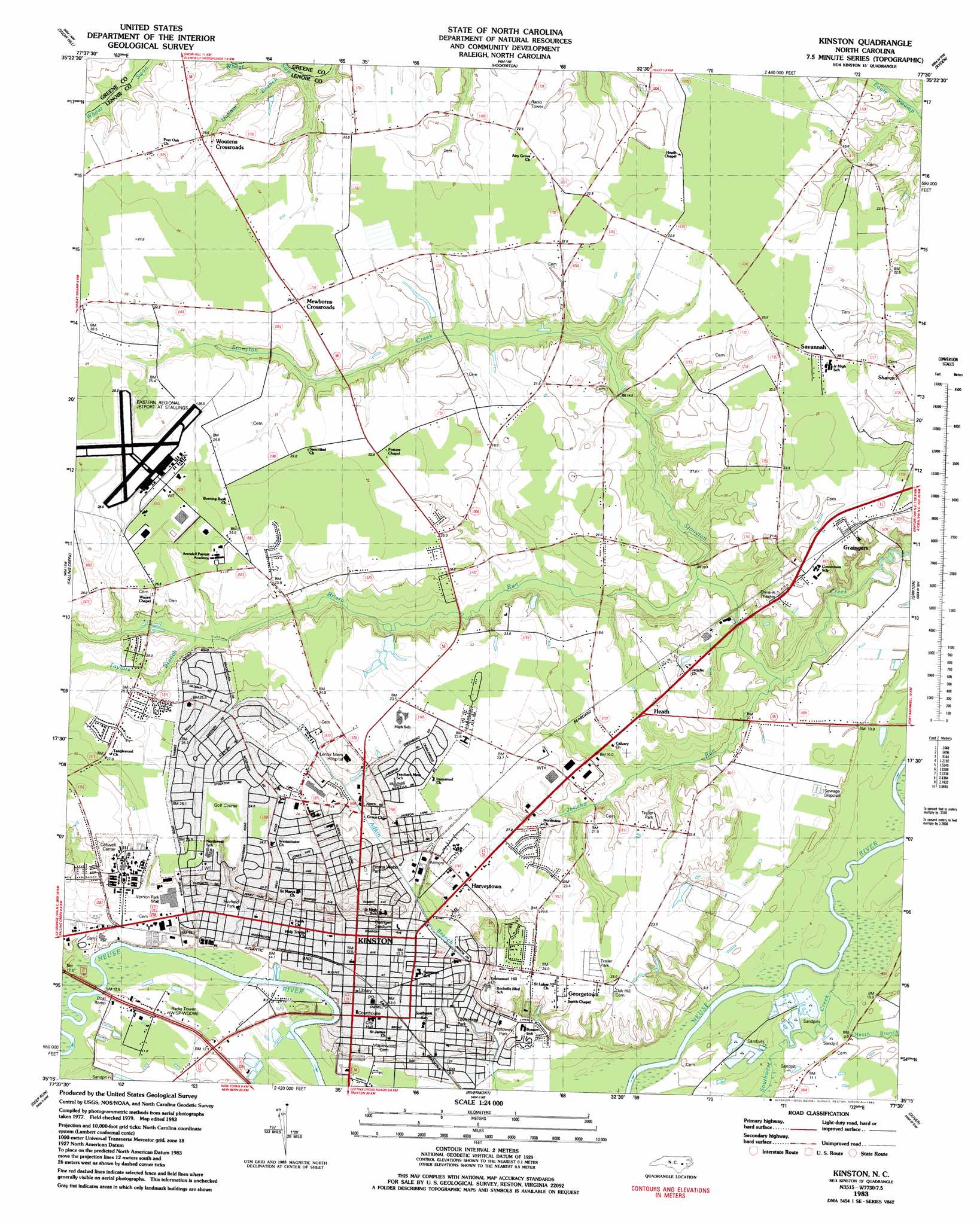
Kinston Topo Map North Carolina
To zoom in, hover over the map of Kinston
USGS Topo Quad 35077c5 - 1:24,000 scale
| Topo Map Name: | Kinston |
| USGS Topo Quad ID: | 35077c5 |
| Print Size: | ca. 21 1/4" wide x 27" high |
| Southeast Coordinates: | 35.25° N latitude / 77.5° W longitude |
| Map Center Coordinates: | 35.3125° N latitude / 77.5625° W longitude |
| U.S. State: | NC |
| Filename: | o35077c5.jpg |
| Download Map JPG Image: | Kinston topo map 1:24,000 scale |
| Map Type: | Topographic |
| Topo Series: | 7.5´ |
| Map Scale: | 1:24,000 |
| Source of Map Images: | United States Geological Survey (USGS) |
| Alternate Map Versions: |
Kinston NC 1983, updated 1983 Download PDF Buy paper map Kinston NC 1998, updated 2001 Download PDF Buy paper map Kinston NC 2010 Download PDF Buy paper map Kinston NC 2013 Download PDF Buy paper map Kinston NC 2016 Download PDF Buy paper map |
1:24,000 Topo Quads surrounding Kinston
Stantonsburg |
Walstonburg |
Farmville |
Greenville Sw |
Greenville Se |
Jason |
Snow Hill |
Hookerton |
Ayden |
Gardnerville |
La Grange |
Falling Creek |
Kinston |
Grifton |
Fort Barnwell |
Seven Springs |
Deep Run |
Rivermont |
Dover |
Cove City |
Albertson |
Pink Hill |
Comfort |
Phillips Crossroads |
Trenton |
> Back to 35077a1 at 1:100,000 scale
> Back to 35076a1 at 1:250,000 scale
> Back to U.S. Topo Maps home
Kinston topo map: Gazetteer
Kinston: Airports
Eastern Regional Jetport at Stallings Field elevation 27m 88′Kinston: Parks
Bill Fay Memorial Park elevation 23m 75′Caswell-Newse State Historic Site elevation 12m 39′
Emma Webb Park elevation 17m 55′
Fairfield Park elevation 16m 52′
Grainger Stadium elevation 14m 45′
Holloway Park elevation 9m 29′
Lovit Hires Park elevation 12m 39′
Southeast Park elevation 12m 39′
Kinston: Populated Places
Brentwood elevation 23m 75′Bynum Park elevation 10m 32′
Centennial Arms elevation 23m 75′
Club Pines elevation 25m 82′
Clubview elevation 24m 78′
Colonial Hights elevation 26m 85′
Country Club Estates elevation 24m 78′
Eastover elevation 18m 59′
Edgefield Forest elevation 26m 85′
George Washington Carver elevation 12m 39′
Georgetown elevation 24m 78′
Graingers elevation 22m 72′
Greenmead elevation 24m 78′
Grove Park elevation 12m 39′
Happersville (historical) elevation 12m 39′
Hardee Heights elevation 25m 82′
Harveytown elevation 24m 78′
Heath elevation 19m 62′
Hines Junction elevation 12m 39′
Howard Hights elevation 19m 62′
Kenwood Acres elevation 25m 82′
Kinfield Village elevation 10m 32′
Kingwood Forest elevation 24m 78′
Kinston elevation 13m 42′
Lawarence Hights elevation 20m 65′
Lenoir Pines elevation 25m 82′
Liberty Hill Park elevation 14m 45′
Mewborns Crossroads elevation 24m 78′
Northview elevation 23m 75′
Oak Lawn elevation 21m 68′
Old Farm elevation 24m 78′
Perry Park elevation 24m 78′
Rolling Pines elevation 23m 75′
Savannah elevation 22m 72′
Sharon elevation 22m 72′
Sherwood Forest elevation 22m 72′
Sleepy Fox Village Mobile Home Park elevation 12m 39′
Tanglewood elevation 26m 85′
Tarheel Courts elevation 23m 75′
Tower Heights elevation 24m 78′
Tyndall Park elevation 9m 29′
West haven elevation 24m 78′
Westwood elevation 21m 68′
Woods View elevation 20m 65′
Wootens Crossroads elevation 22m 72′
Kinston: Post Offices
Kinston Post Office elevation 12m 39′Kinston: Streams
Briery Run elevation 10m 32′Hallam Branch elevation 14m 45′
Heath Branch elevation 4m 13′
Jericho Run elevation 10m 32′
Southwest Creek elevation 4m 13′
Taylors Branch elevation 18m 59′
Kinston digital topo map on disk
Buy this Kinston topo map showing relief, roads, GPS coordinates and other geographical features, as a high-resolution digital map file on DVD:
Atlantic Coast (NY, NJ, PA, DE, MD, VA, NC)
Buy digital topo maps: Atlantic Coast (NY, NJ, PA, DE, MD, VA, NC)
 map DVD")