Hackney Topo Map North Carolina
To zoom in, hover over the map of Hackney
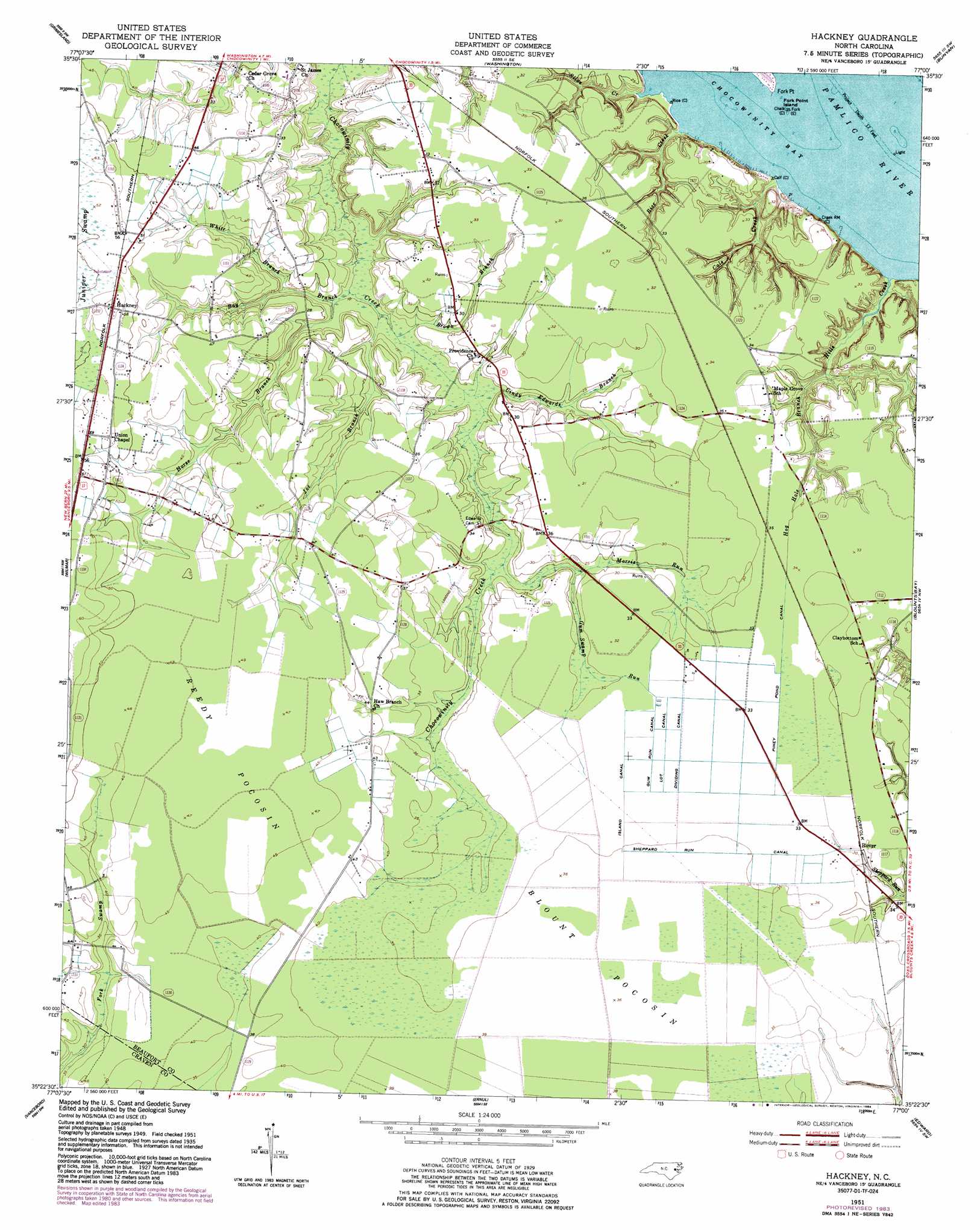
USGS Topo Quad 35077d1 - 1:24,000 scale
| Topo Map Name: | Hackney |
| USGS Topo Quad ID: | 35077d1 |
| Print Size: | ca. 21 1/4" wide x 27" high |
| Southeast Coordinates: | 35.375° N latitude / 77° W longitude |
| Map Center Coordinates: | 35.4375° N latitude / 77.0625° W longitude |
| U.S. State: | NC |
| Filename: | o35077d1.jpg |
| Download Map JPG Image: | Hackney topo map 1:24,000 scale |
| Map Type: | Topographic |
| Topo Series: | 7.5´ |
| Map Scale: | 1:24,000 |
| Source of Map Images: | United States Geological Survey (USGS) |
| Alternate Map Versions: |
Hackney NC 1951, updated 1953 Download PDF Buy paper map Hackney NC 1951, updated 1977 Download PDF Buy paper map Hackney NC 1951, updated 1984 Download PDF Buy paper map Hackney NC 1997, updated 2001 Download PDF Buy paper map Hackney NC 2010 Download PDF Buy paper map Hackney NC 2013 Download PDF Buy paper map Hackney NC 2016 Download PDF Buy paper map |
1:24,000 Topo Quads surrounding Hackney
Greenville Ne |
Leggetts Crossroads |
Old Ford |
Farmlife |
Hoke |
Greenville Se |
Grimesland |
Washington |
Bunyan |
Pinetown |
Gardnerville |
Wilmar |
Hackney |
Blounts Bay |
Bath |
Fort Barnwell |
Vanceboro |
Ernul |
Edward |
Aurora |
Cove City |
Jasper |
Askin |
Reelsboro |
Bayboro |
> Back to 35077a1 at 1:100,000 scale
> Back to 35076a1 at 1:250,000 scale
> Back to U.S. Topo Maps home
Hackney topo map: Gazetteer
Hackney: Canals
Dividing Canal elevation 10m 32′Gum Run Canal elevation 10m 32′
Island Canal elevation 10m 32′
Lot Canal elevation 10m 32′
Piney Pond Canal elevation 10m 32′
Sheppard Run Canal elevation 10m 32′
Hackney: Capes
Fork Point elevation 0m 0′Hackney: Islands
Fork Point Island elevation 0m 0′Hackney: Populated Places
Hackney elevation 18m 59′McConnell elevation 9m 29′
Rover elevation 10m 32′
Hackney: Streams
Bay Branch elevation 2m 6′Brown Branch elevation 3m 9′
Cals Creek elevation 0m 0′
Cindy Edwards Branch elevation 3m 9′
Gum Swamp Run elevation 7m 22′
Hills Creek elevation 0m 0′
Hog Hole Branch elevation 2m 6′
Horse Branch elevation 3m 9′
Joe Branch elevation 3m 9′
Morris Run elevation 6m 19′
Rice Creek elevation 0m 0′
Silas Creek elevation 1m 3′
White Branch elevation 5m 16′
Hackney: Swamps
Blount Pocosin elevation 10m 32′Juniper Swamp elevation 16m 52′
Reedy Pocosin elevation 14m 45′
Hackney digital topo map on disk
Buy this Hackney topo map showing relief, roads, GPS coordinates and other geographical features, as a high-resolution digital map file on DVD:
Atlantic Coast (NY, NJ, PA, DE, MD, VA, NC)
Buy digital topo maps: Atlantic Coast (NY, NJ, PA, DE, MD, VA, NC)
 map DVD")