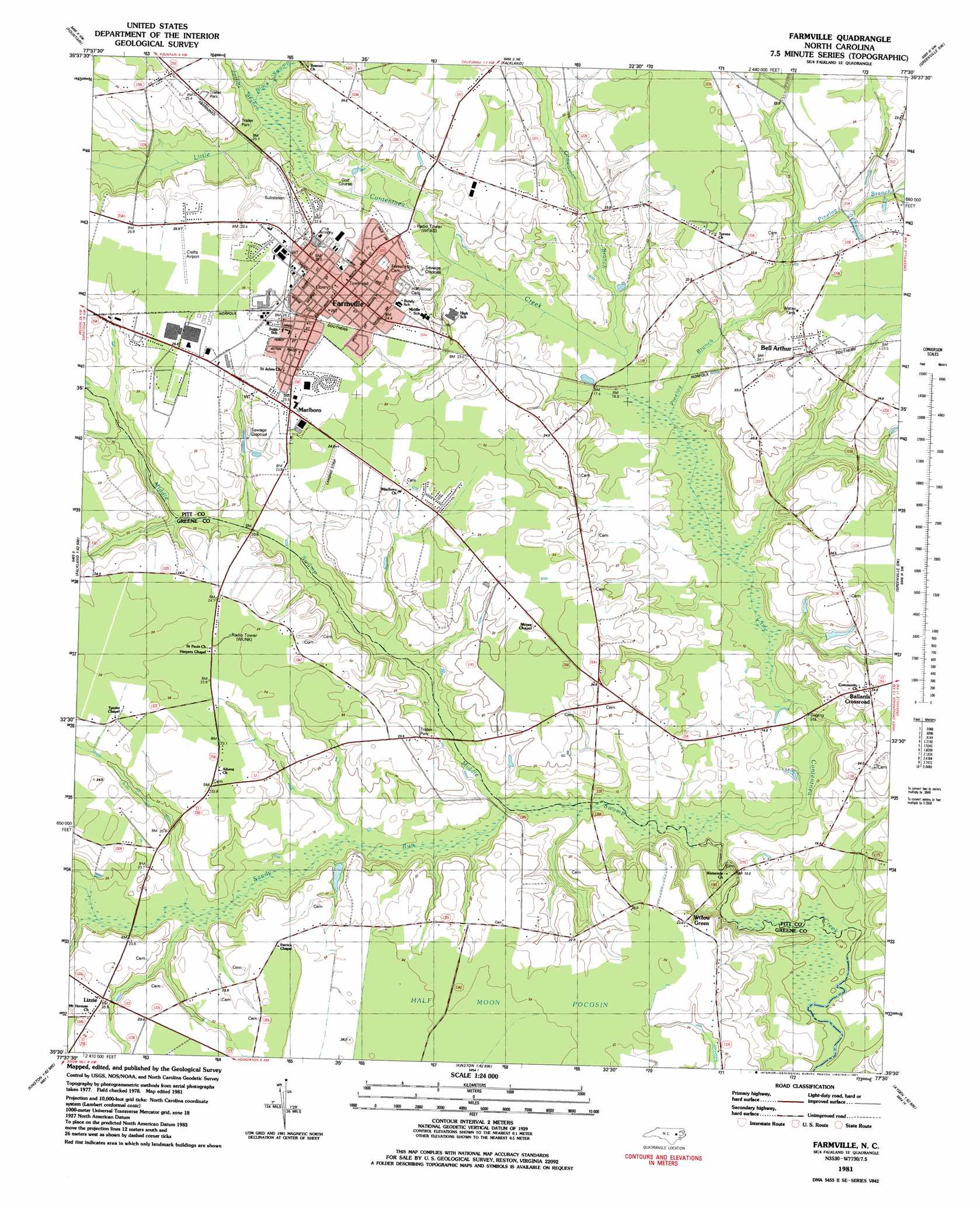
Farmville Topo Map North Carolina
To zoom in, hover over the map of Farmville
USGS Topo Quad 35077e5 - 1:24,000 scale
| Topo Map Name: | Farmville |
| USGS Topo Quad ID: | 35077e5 |
| Print Size: | ca. 21 1/4" wide x 27" high |
| Southeast Coordinates: | 35.5° N latitude / 77.5° W longitude |
| Map Center Coordinates: | 35.5625° N latitude / 77.5625° W longitude |
| U.S. State: | NC |
| Filename: | o35077e5.jpg |
| Download Map JPG Image: | Farmville topo map 1:24,000 scale |
| Map Type: | Topographic |
| Topo Series: | 7.5´ |
| Map Scale: | 1:24,000 |
| Source of Map Images: | United States Geological Survey (USGS) |
| Alternate Map Versions: |
Farmville NC 1981, updated 1981 Download PDF Buy paper map Farmville NC 2010 Download PDF Buy paper map Farmville NC 2013 Download PDF Buy paper map Farmville NC 2016 Download PDF Buy paper map |
1:24,000 Topo Quads surrounding Farmville
Elm City |
Pinetops |
Old Sparta |
Conetoe |
Robersonville West |
Saratoga |
Fountain |
Falkland |
Greenville Nw |
Greenville Ne |
Stantonsburg |
Walstonburg |
Farmville |
Greenville Sw |
Greenville Se |
Jason |
Snow Hill |
Hookerton |
Ayden |
Gardnerville |
La Grange |
Falling Creek |
Kinston |
Grifton |
Fort Barnwell |
> Back to 35077e1 at 1:100,000 scale
> Back to 35076a1 at 1:250,000 scale
> Back to U.S. Topo Maps home
Farmville topo map: Gazetteer
Farmville: Airports
Crafts Airport elevation 25m 82′Farmville: Parks
J Y Monk Park elevation 24m 78′Municipal Athletic Park elevation 19m 62′
Farmville: Populated Places
Ballards Crossroad elevation 25m 82′Bell Arthur elevation 24m 78′
Birchwood elevation 25m 82′
Farmville elevation 25m 82′
Kittrell Hill elevation 23m 75′
Lakeside Fore Mobile Home Park elevation 23m 75′
Lanes Crossroads - Mobile Home Park elevation 24m 78′
Lizzie elevation 22m 72′
Marlboro elevation 25m 82′
Marlboro Forest elevation 25m 82′
Matthews Mobile Home Park elevation 24m 78′
North Ridge elevation 25m 82′
Pine Grove Apartments elevation 25m 82′
Watkins Way Mobile Home Park elevation 24m 78′
Willow Creek elevation 21m 68′
Farmville: Post Offices
Bellarthur Post Office elevation 24m 78′Pleasant Mount Post Office elevation 14m 45′
Farmville: Streams
Black Swamp elevation 17m 55′Jacob Branch elevation 17m 55′
Middle Swamp elevation 11m 36′
Oldwoman Branch elevation 15m 49′
Pinelog Branch elevation 14m 45′
Sandy Run elevation 12m 39′
Farmville: Swamps
Half Moon Pocosin elevation 24m 78′Farmville digital topo map on disk
Buy this Farmville topo map showing relief, roads, GPS coordinates and other geographical features, as a high-resolution digital map file on DVD:
Atlantic Coast (NY, NJ, PA, DE, MD, VA, NC)
Buy digital topo maps: Atlantic Coast (NY, NJ, PA, DE, MD, VA, NC)
 map DVD")