Greenville Nw Topo Map North Carolina
To zoom in, hover over the map of Greenville Nw
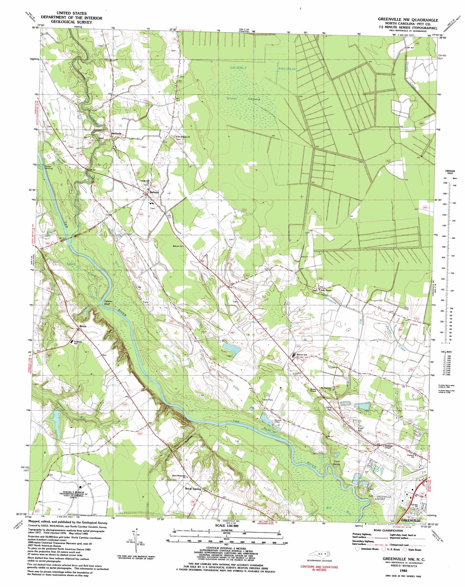
USGS Topo Quad 35077f4 - 1:24,000 scale
| Topo Map Name: | Greenville Nw |
| USGS Topo Quad ID: | 35077f4 |
| Print Size: | ca. 21 1/4" wide x 27" high |
| Southeast Coordinates: | 35.625° N latitude / 77.375° W longitude |
| Map Center Coordinates: | 35.6875° N latitude / 77.4375° W longitude |
| U.S. State: | NC |
| Filename: | o35077f4.jpg |
| Download Map JPG Image: | Greenville Nw topo map 1:24,000 scale |
| Map Type: | Topographic |
| Topo Series: | 7.5´ |
| Map Scale: | 1:24,000 |
| Source of Map Images: | United States Geological Survey (USGS) |
| Alternate Map Versions: |
Greenville NW NC 1982, updated 1982 Download PDF Buy paper map Greenville NW NC 1998, updated 2001 Download PDF Buy paper map Greenville NW NC 2010 Download PDF Buy paper map Greenville NW NC 2013 Download PDF Buy paper map Greenville NW NC 2016 Download PDF Buy paper map |
1:24,000 Topo Quads surrounding Greenville Nw
Hartsease |
Tarboro |
Speed |
Oak City |
Hamilton |
Pinetops |
Old Sparta |
Conetoe |
Robersonville West |
Robersonville East |
Fountain |
Falkland |
Greenville Nw |
Greenville Ne |
Leggetts Crossroads |
Walstonburg |
Farmville |
Greenville Sw |
Greenville Se |
Grimesland |
Snow Hill |
Hookerton |
Ayden |
Gardnerville |
Wilmar |
> Back to 35077e1 at 1:100,000 scale
> Back to 35076a1 at 1:250,000 scale
> Back to U.S. Topo Maps home
Greenville Nw topo map: Gazetteer
Greenville Nw: Airports
Pitt-Greenville Airport elevation 6m 19′Greenville Nw: Bars
Little Blue Banks elevation 1m 3′Greenville Nw: Dams
NC Noname Eight-Hundred Forty-Seven Dam elevation 19m 62′Greenville Nw: Levees
Clark Banks elevation 6m 19′Greenville Nw: Populated Places
Bells Crossroads elevation 11m 36′Belvoir elevation 11m 36′
Birchwoods Sands Mobile Home Park elevation 9m 29′
Bruce elevation 23m 75′
Country Paradise Mobile Home Park elevation 9m 29′
Eagle Ridge Mobile Home Park elevation 11m 36′
Eastwood Mobile Home Park elevation 7m 22′
Hollands elevation 9m 29′
River Road Minor elevation 8m 26′
Rock Spring elevation 25m 82′
USAR Center elevation 6m 19′
Victory Mobile Home Park elevation 10m 32′
Greenville Nw: Reservoirs
Allens Pond elevation 19m 62′Greenville Nw: Streams
Bryan Creek elevation 1m 3′Conetoe Creek elevation 6m 19′
Harris Mill Run elevation 2m 6′
Johnsons Mill Run elevation 6m 19′
Otter Creek elevation 7m 22′
Sains Branch elevation 1m 3′
Sams Branch elevation 6m 19′
Tyson Creek elevation 4m 13′
Greenville Nw: Swamps
Great Swamp elevation 13m 42′Grindle Pocosin elevation 13m 42′
Greenville Nw digital topo map on disk
Buy this Greenville Nw topo map showing relief, roads, GPS coordinates and other geographical features, as a high-resolution digital map file on DVD:
Atlantic Coast (NY, NJ, PA, DE, MD, VA, NC)
Buy digital topo maps: Atlantic Coast (NY, NJ, PA, DE, MD, VA, NC)
 map DVD")