Saratoga Topo Map North Carolina
To zoom in, hover over the map of Saratoga
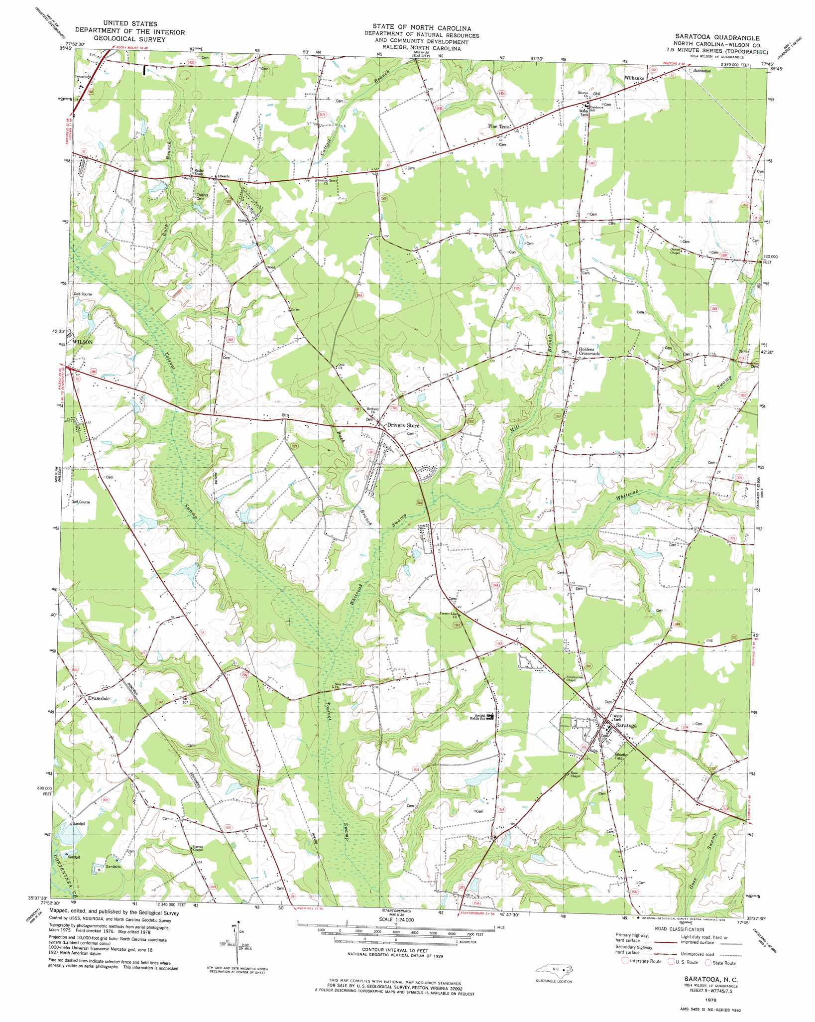
USGS Topo Quad 35077f7 - 1:24,000 scale
| Topo Map Name: | Saratoga |
| USGS Topo Quad ID: | 35077f7 |
| Print Size: | ca. 21 1/4" wide x 27" high |
| Southeast Coordinates: | 35.625° N latitude / 77.75° W longitude |
| Map Center Coordinates: | 35.6875° N latitude / 77.8125° W longitude |
| U.S. State: | NC |
| Filename: | o35077f7.jpg |
| Download Map JPG Image: | Saratoga topo map 1:24,000 scale |
| Map Type: | Topographic |
| Topo Series: | 7.5´ |
| Map Scale: | 1:24,000 |
| Source of Map Images: | United States Geological Survey (USGS) |
| Alternate Map Versions: |
Saratoga NC 1978, updated 1978 Download PDF Buy paper map Saratoga NC 2010 Download PDF Buy paper map Saratoga NC 2013 Download PDF Buy paper map Saratoga NC 2016 Download PDF Buy paper map |
1:24,000 Topo Quads surrounding Saratoga
Spring Hope |
Nashville |
Rocky Mount |
Hartsease |
Tarboro |
Bailey |
Winstead Crossroads |
Elm City |
Pinetops |
Old Sparta |
Lucama |
Wilson |
Saratoga |
Fountain |
Falkland |
Kenly East |
Fremont |
Stantonsburg |
Walstonburg |
Farmville |
Northwest Goldsboro |
Northeast Goldsboro |
Jason |
Snow Hill |
Hookerton |
> Back to 35077e1 at 1:100,000 scale
> Back to 35076a1 at 1:250,000 scale
> Back to U.S. Topo Maps home
Saratoga topo map: Gazetteer
Saratoga: Dams
Archie Ellis Pond Dam elevation 31m 101′Edmunson Pond Dam elevation 30m 98′
Harrells Lake Dam elevation 27m 88′
Wainwright Pond Dam elevation 25m 82′
Woodards Pond Dam elevation 30m 98′
Saratoga: Populated Places
Drivers Store elevation 35m 114′Eastwood elevation 37m 121′
Evansdale elevation 36m 118′
Holdens Crossroads elevation 33m 108′
Pine Tree elevation 36m 118′
Saratoga elevation 36m 118′
Sun elevation 37m 121′
Wilbanks elevation 37m 121′
Saratoga: Reservoirs
Archie Ellis Pond elevation 31m 101′Edmunson Pond elevation 30m 98′
Harrells Lake elevation 27m 88′
Wainwright Pond elevation 25m 82′
Woodards Pond elevation 30m 98′
Saratoga: Streams
Buck Branch elevation 23m 75′Buck Branch elevation 25m 82′
Mill Branch elevation 24m 78′
Whiteoak Swamp elevation 20m 65′
Saratoga digital topo map on disk
Buy this Saratoga topo map showing relief, roads, GPS coordinates and other geographical features, as a high-resolution digital map file on DVD:
Atlantic Coast (NY, NJ, PA, DE, MD, VA, NC)
Buy digital topo maps: Atlantic Coast (NY, NJ, PA, DE, MD, VA, NC)
 map DVD")