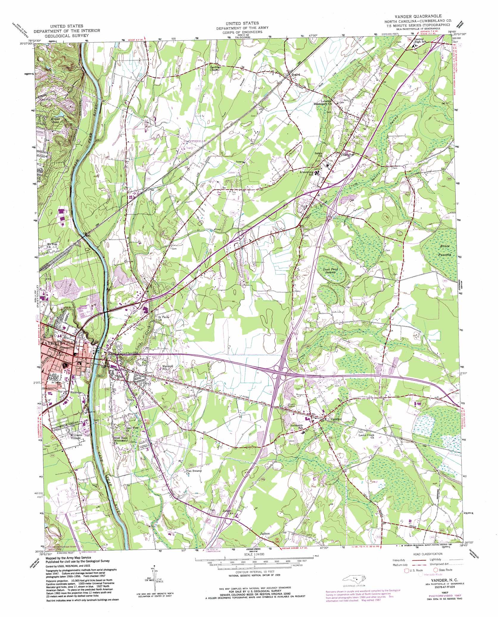
Vander Topo Map North Carolina
To zoom in, hover over the map of Vander
USGS Topo Quad 35078a7 - 1:24,000 scale
| Topo Map Name: | Vander |
| USGS Topo Quad ID: | 35078a7 |
| Print Size: | ca. 21 1/4" wide x 27" high |
| Southeast Coordinates: | 35° N latitude / 78.75° W longitude |
| Map Center Coordinates: | 35.0625° N latitude / 78.8125° W longitude |
| U.S. State: | NC |
| Filename: | o35078a7.jpg |
| Download Map JPG Image: | Vander topo map 1:24,000 scale |
| Map Type: | Topographic |
| Topo Series: | 7.5´ |
| Map Scale: | 1:24,000 |
| Source of Map Images: | United States Geological Survey (USGS) |
| Alternate Map Versions: |
Vander NC 1949 Download PDF Buy paper map Vander NC 1949 Download PDF Buy paper map Vander NC 1957, updated 1960 Download PDF Buy paper map Vander NC 1957, updated 1973 Download PDF Buy paper map Vander NC 1957, updated 1983 Download PDF Buy paper map Vander NC 1957, updated 1987 Download PDF Buy paper map Vander NC 1976, updated 1978 Download PDF Buy paper map Vander NC 1997, updated 2000 Download PDF Buy paper map Vander NC 2010 Download PDF Buy paper map Vander NC 2013 Download PDF Buy paper map Vander NC 2016 Download PDF Buy paper map |
1:24,000 Topo Quads surrounding Vander
Olivia |
Anderson Creek |
Bunnlevel |
Erwin |
Dunn |
Overhills |
Manchester |
Slocomb |
Wade |
Mingo |
Clifdale |
Fayetteville |
Vander |
Stedman |
Salemburg |
Parkton |
Hope Mills |
Cedar Creek |
Autryville |
Roseboro |
Rennert |
Saint Pauls |
Duart |
Jerome |
Ammon |
> Back to 35078a1 at 1:100,000 scale
> Back to 35078a1 at 1:250,000 scale
> Back to U.S. Topo Maps home
Vander topo map: Gazetteer
Vander: Airports
Fayetteville VAH Airport elevation 57m 187′Vander: Canals
Flat Swamp Ditch elevation 29m 95′Gum Log Canal elevation 28m 91′
Vander: Dams
Watson Lake Dam elevation 32m 104′Vander: Parks
Clarks Park elevation 27m 88′Cumberland County Park elevation 24m 78′
Pope Park elevation 26m 85′
Vander: Populated Places
Beard elevation 30m 98′Cade Hill elevation 29m 95′
East Fayetteville elevation 22m 72′
Eastover elevation 29m 95′
Fairview Park elevation 28m 91′
Heritage Heights elevation 38m 124′
Highland Acres elevation 27m 88′
Hollywood elevation 25m 82′
Judson elevation 29m 95′
Rivercliff elevation 62m 203′
Tranquil Acres elevation 29m 95′
Vander elevation 38m 124′
Williams Village elevation 26m 85′
Vander: Reservoirs
Evans Lake elevation 43m 141′Watson Lake elevation 32m 104′
Vander: Streams
Bakers Swamp elevation 32m 104′Blounts Creek elevation 17m 55′
Cross Creek elevation 13m 42′
Locks Creek elevation 23m 75′
Locks Creek elevation 13m 42′
Reese Creek elevation 28m 91′
Vander: Swamps
Brace Pocosin elevation 42m 137′Duck Pond Swamp elevation 38m 124′
Vander digital topo map on disk
Buy this Vander topo map showing relief, roads, GPS coordinates and other geographical features, as a high-resolution digital map file on DVD:
South Carolina, Western North Carolina & Northeastern Georgia
Buy digital topo maps: South Carolina, Western North Carolina & Northeastern Georgia