Fayetteville Topo Map North Carolina
To zoom in, hover over the map of Fayetteville
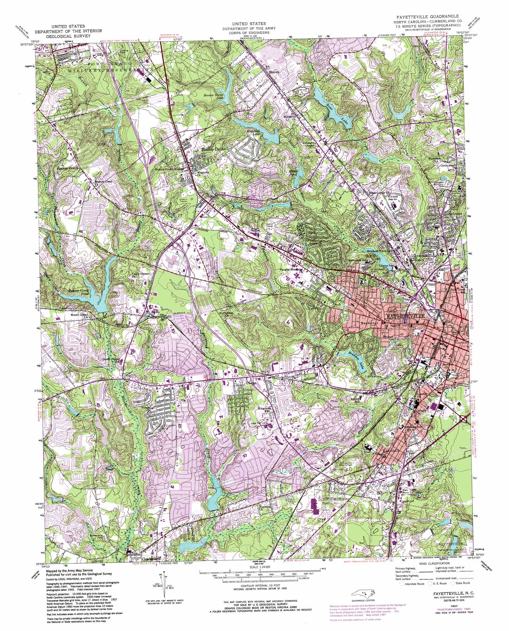
USGS Topo Quad 35078a8 - 1:24,000 scale
| Topo Map Name: | Fayetteville |
| USGS Topo Quad ID: | 35078a8 |
| Print Size: | ca. 21 1/4" wide x 27" high |
| Southeast Coordinates: | 35° N latitude / 78.875° W longitude |
| Map Center Coordinates: | 35.0625° N latitude / 78.9375° W longitude |
| U.S. State: | NC |
| Filename: | o35078a8.jpg |
| Download Map JPG Image: | Fayetteville topo map 1:24,000 scale |
| Map Type: | Topographic |
| Topo Series: | 7.5´ |
| Map Scale: | 1:24,000 |
| Source of Map Images: | United States Geological Survey (USGS) |
| Alternate Map Versions: |
Fayetteville NC 1950 Download PDF Buy paper map Fayetteville NC 1950 Download PDF Buy paper map Fayetteville NC 1957, updated 1960 Download PDF Buy paper map Fayetteville NC 1957, updated 1973 Download PDF Buy paper map Fayetteville NC 1957, updated 1983 Download PDF Buy paper map Fayetteville NC 1957, updated 1987 Download PDF Buy paper map Fayetteville NC 1957, updated 1987 Download PDF Buy paper map Fayetteville NC 1976, updated 1978 Download PDF Buy paper map Fayetteville NC 1997, updated 2000 Download PDF Buy paper map Fayetteville NC 2013 Download PDF Buy paper map Fayetteville NC 2016 Download PDF Buy paper map |
1:24,000 Topo Quads surrounding Fayetteville
Murchisontown |
Olivia |
Anderson Creek |
Bunnlevel |
Erwin |
Lobelia |
Overhills |
Manchester |
Slocomb |
Wade |
Nicholson Creek |
Clifdale |
Fayetteville |
Vander |
Stedman |
Raeford |
Parkton |
Hope Mills |
Cedar Creek |
Autryville |
Red Springs |
Rennert |
Saint Pauls |
Duart |
Jerome |
> Back to 35078a1 at 1:100,000 scale
> Back to 35078a1 at 1:250,000 scale
> Back to U.S. Topo Maps home
Fayetteville topo map: Gazetteer
Fayetteville: Airports
Beard Airport elevation 56m 183′Cape Fear Valley Hospital Airport elevation 62m 203′
Fayetteville: Dams
Arran Lake Dam elevation 55m 180′Beaver Creek Dam elevation 50m 164′
Bonne Doone Lake Dam elevation 53m 173′
Clarks Pond Dam elevation 46m 150′
Country Club Lake Dam elevation 42m 137′
Cumberland Pond Dam elevation 39m 127′
Forrest Lake Dam elevation 54m 177′
Glenville Lake Dam elevation 44m 144′
Kornbow Lake Dam elevation 48m 157′
Lake Walter Dam elevation 39m 127′
Mintz Pond Dam elevation 41m 134′
Pete Fann Dam elevation 44m 144′
Rose Lake Dam elevation 43m 141′
Wallace Pond Dam elevation 43m 141′
Warren Lake Dam elevation 37m 121′
Wilson Lake Dam elevation 36m 118′
Fayetteville: Parks
Mazarick Park elevation 40m 131′Fayetteville: Populated Places
Arran Hills elevation 64m 209′Arran Lakes elevation 57m 187′
Arran Lakes North elevation 62m 203′
Arran Lakes West elevation 51m 167′
Beaver Creek elevation 76m 249′
Belair elevation 63m 206′
Bizza Ridge elevation 84m 275′
Bonnie Doone elevation 71m 232′
Bordeaux elevation 61m 200′
Borden Heights elevation 53m 173′
Breezewood Acres elevation 65m 213′
Brentwood elevation 63m 206′
Bridle Creek elevation 62m 203′
Broad Acres elevation 51m 167′
Broadell elevation 47m 154′
Cambridge elevation 70m 229′
Chestnut Hills elevation 58m 190′
Clairway elevation 57m 187′
Cottonade elevation 73m 239′
Country Club North elevation 59m 193′
Crossgates elevation 63m 206′
Crystal Park elevation 51m 167′
Cumberland elevation 56m 183′
Dogwood Acres elevation 52m 170′
Ducks Landing elevation 56m 183′
Eccles Park elevation 51m 167′
Edenroc elevation 61m 200′
Englewood elevation 64m 209′
Eutaw elevation 66m 216′
Evergreen Estates elevation 58m 190′
Fayetteville elevation 31m 101′
Forest Hills elevation 45m 147′
Foxfire elevation 71m 232′
Glendale Acres elevation 65m 213′
Glenhaven elevation 65m 213′
Green Valley Estates elevation 59m 193′
Greenwood Homes elevation 58m 190′
Haymount elevation 62m 203′
Hermitage elevation 67m 219′
Highland Village elevation 41m 134′
Hillendale elevation 59m 193′
Holiday Park elevation 52m 170′
Holly Springs elevation 60m 196′
Hollywood Heights elevation 54m 177′
Howard Acres elevation 68m 223′
Huntington Park elevation 64m 209′
Kingsford elevation 67m 219′
Kirkwood elevation 68m 223′
Kornbow elevation 65m 213′
Lake Shores elevation 58m 190′
Lake Valley elevation 64m 209′
Lakecrest elevation 59m 193′
Lakedale elevation 56m 183′
Legion Park elevation 64m 209′
Lockwood elevation 47m 154′
Longview Acres elevation 62m 203′
Mayfair elevation 64m 209′
McPherson Estates elevation 57m 187′
Montclair elevation 65m 213′
Murray Hills elevation 67m 219′
Myrtle Hill elevation 60m 196′
North Point Village elevation 55m 180′
Northwood elevation 56m 183′
Oakdale elevation 62m 203′
Oakland elevation 67m 219′
Owens elevation 66m 216′
Phoenician Woods elevation 60m 196′
Pleasant Acres elevation 65m 213′
Quail Ridge elevation 60m 196′
Queensdale elevation 56m 183′
Rollingwood elevation 65m 213′
Sadie Heights elevation 60m 196′
Savoy Heights elevation 51m 167′
Scotty Hills elevation 56m 183′
Seabrook Hills elevation 57m 187′
Shadowlawn elevation 61m 200′
Shaws elevation 68m 223′
Shenandoah elevation 58m 190′
Sherwood Park elevation 54m 177′
Skibo elevation 67m 219′
South Hills elevation 49m 160′
Stradford Hills elevation 67m 219′
Summer elevation 80m 262′
Summertime elevation 67m 219′
Talleywood elevation 59m 193′
The Greens elevation 63m 206′
The Lakes elevation 61m 200′
The Oaks elevation 61m 200′
Tokay elevation 70m 229′
University Estates elevation 66m 216′
University Hills elevation 47m 154′
Vanstory Hills elevation 66m 216′
Vineland Park elevation 54m 177′
Warrenwood elevation 69m 226′
Waters Edge elevation 58m 190′
Westchester elevation 66m 216′
Westwood elevation 68m 223′
Winter Park elevation 61m 200′
Woodfield elevation 53m 173′
Woodlea elevation 57m 187′
Woods Edge elevation 59m 193′
Yadkins Acres elevation 71m 232′
Fayetteville: Reservoirs
Arran Lake elevation 55m 180′Beaver Creek Pond elevation 45m 147′
Bonnie Doone Lake elevation 53m 173′
Branson Lake elevation 37m 121′
Clarks Pond elevation 46m 150′
Country Club Lake elevation 42m 137′
Cumberland Pond elevation 39m 127′
Forrest Lake elevation 54m 177′
Glenville Lake elevation 35m 114′
Glenville Lake elevation 44m 144′
Kornbow Lake elevation 48m 157′
Lake Walter elevation 39m 127′
McFadyen Lake elevation 50m 164′
Mintz Pond elevation 41m 134′
Rose Lake elevation 42m 137′
Roses Lake elevation 43m 141′
Wallace Pond elevation 43m 141′
Warren Lake elevation 37m 121′
Wilson Lake elevation 36m 118′
Fayetteville: Streams
Big Branch elevation 56m 183′Branson Creek elevation 30m 98′
Hybarts Branch elevation 38m 124′
Little Cross Creek elevation 28m 91′
Persimmon Creek elevation 49m 160′
Stewart Creek elevation 49m 160′
Fayetteville digital topo map on disk
Buy this Fayetteville topo map showing relief, roads, GPS coordinates and other geographical features, as a high-resolution digital map file on DVD:
South Carolina, Western North Carolina & Northeastern Georgia
Buy digital topo maps: South Carolina, Western North Carolina & Northeastern Georgia