Manchester Topo Map North Carolina
To zoom in, hover over the map of Manchester
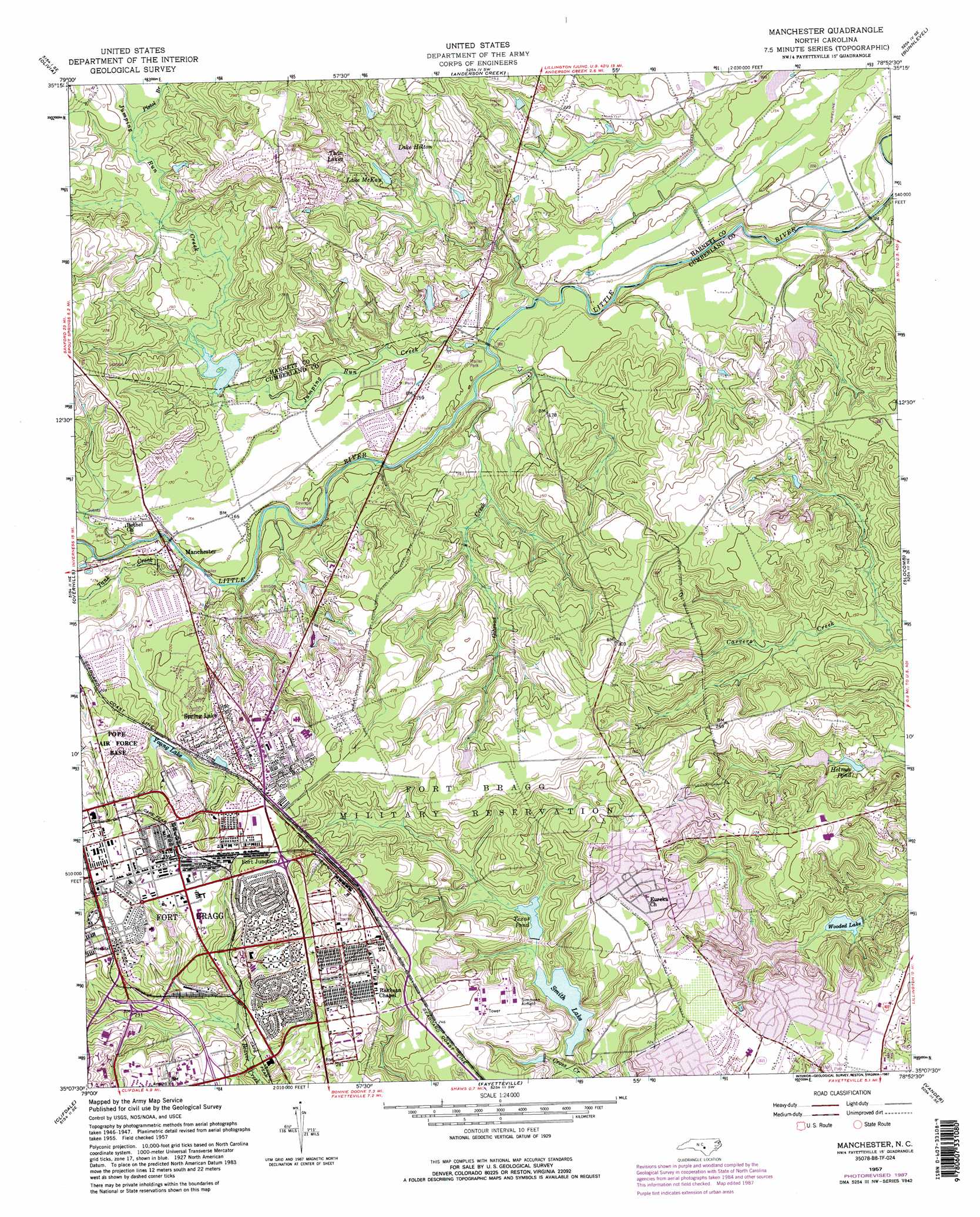
USGS Topo Quad 35078b8 - 1:24,000 scale
| Topo Map Name: | Manchester |
| USGS Topo Quad ID: | 35078b8 |
| Print Size: | ca. 21 1/4" wide x 27" high |
| Southeast Coordinates: | 35.125° N latitude / 78.875° W longitude |
| Map Center Coordinates: | 35.1875° N latitude / 78.9375° W longitude |
| U.S. State: | NC |
| Filename: | o35078b8.jpg |
| Download Map JPG Image: | Manchester topo map 1:24,000 scale |
| Map Type: | Topographic |
| Topo Series: | 7.5´ |
| Map Scale: | 1:24,000 |
| Source of Map Images: | United States Geological Survey (USGS) |
| Alternate Map Versions: |
Manchester NC 1950 Download PDF Buy paper map Manchester NC 1957, updated 1960 Download PDF Buy paper map Manchester NC 1957, updated 1973 Download PDF Buy paper map Manchester NC 1957, updated 1982 Download PDF Buy paper map Manchester NC 1957, updated 1987 Download PDF Buy paper map Manchester NC 1976, updated 1978 Download PDF Buy paper map Manchester NC 1997, updated 2000 Download PDF Buy paper map Manchester NC 2013 Download PDF Buy paper map Manchester NC 2016 Download PDF Buy paper map |
1:24,000 Topo Quads surrounding Manchester
Sanford |
Broadway |
Mamers |
Lillington |
Coats |
Murchisontown |
Olivia |
Anderson Creek |
Bunnlevel |
Erwin |
Lobelia |
Overhills |
Manchester |
Slocomb |
Wade |
Nicholson Creek |
Clifdale |
Fayetteville |
Vander |
Stedman |
Raeford |
Parkton |
Hope Mills |
Cedar Creek |
Autryville |
> Back to 35078a1 at 1:100,000 scale
> Back to 35078a1 at 1:250,000 scale
> Back to U.S. Topo Maps home
Manchester topo map: Gazetteer
Manchester: Dams
College Lake Dam elevation 41m 134′Lewis Lake Dam elevation 44m 144′
Long Valley Farm Lake Dam elevation 46m 150′
Mitchells Pond Dam elevation 48m 157′
NC Noname One-Thousand Thirty-One Dam elevation 68m 223′
Smith Lake Dam elevation 50m 164′
Texas Pond Dam elevation 51m 167′
Manchester: Populated Places
Anzio Acres elevation 75m 246′Ardennes elevation 80m 262′
Ascot II elevation 48m 157′
Bastogne Gables elevation 92m 301′
Bataan elevation 90m 295′
Bougainville elevation 86m 282′
Casablanca elevation 82m 269′
Corregidor elevation 91m 298′
Eureka Springs elevation 73m 239′
Manchester elevation 45m 147′
Normandy Heights elevation 88m 288′
Spring Lake elevation 84m 275′
Twin Lakes elevation 68m 223′
Woodbridge elevation 67m 219′
Manchester: Reservoirs
College Lake elevation 41m 134′Holmes Pond elevation 40m 131′
Lake Holton elevation 57m 187′
Lake McKay elevation 57m 187′
Lewis Lake elevation 44m 144′
Long Valley Farm Lake elevation 46m 150′
Mitchells Pond elevation 48m 157′
Simmons Lake elevation 68m 223′
Smith Lake elevation 50m 164′
Texas Lake elevation 51m 167′
Texas Pond elevation 52m 170′
Wooded Lake elevation 40m 131′
Young Lake elevation 66m 216′
Manchester: Streams
Gibsons Creek elevation 37m 121′Jumping Run Creek elevation 39m 127′
Pistol Branch elevation 54m 177′
Tank Creek elevation 43m 141′
Manchester digital topo map on disk
Buy this Manchester topo map showing relief, roads, GPS coordinates and other geographical features, as a high-resolution digital map file on DVD:
South Carolina, Western North Carolina & Northeastern Georgia
Buy digital topo maps: South Carolina, Western North Carolina & Northeastern Georgia