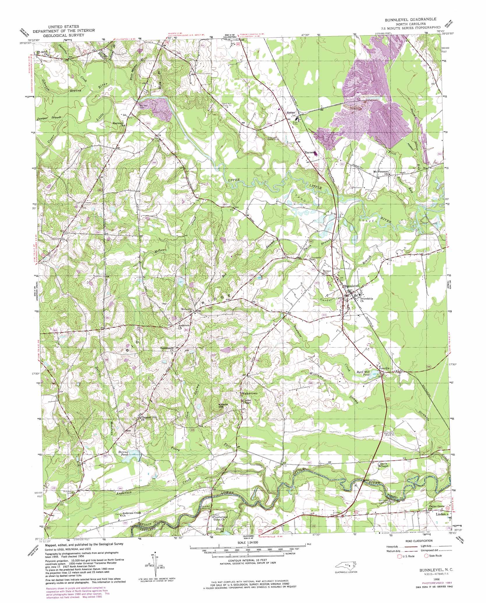
Bunnlevel Topo Map North Carolina
To zoom in, hover over the map of Bunnlevel
USGS Topo Quad 35078c7 - 1:24,000 scale
| Topo Map Name: | Bunnlevel |
| USGS Topo Quad ID: | 35078c7 |
| Print Size: | ca. 21 1/4" wide x 27" high |
| Southeast Coordinates: | 35.25° N latitude / 78.75° W longitude |
| Map Center Coordinates: | 35.3125° N latitude / 78.8125° W longitude |
| U.S. State: | NC |
| Filename: | o35078c7.jpg |
| Download Map JPG Image: | Bunnlevel topo map 1:24,000 scale |
| Map Type: | Topographic |
| Topo Series: | 7.5´ |
| Map Scale: | 1:24,000 |
| Source of Map Images: | United States Geological Survey (USGS) |
| Alternate Map Versions: |
Bunnlevel NC 1956, updated 1958 Download PDF Buy paper map Bunnlevel NC 1956, updated 1982 Download PDF Buy paper map Bunnlevel NC 1997, updated 2000 Download PDF Buy paper map Bunnlevel NC 2010 Download PDF Buy paper map Bunnlevel NC 2013 Download PDF Buy paper map Bunnlevel NC 2016 Download PDF Buy paper map |
1:24,000 Topo Quads surrounding Bunnlevel
Moncure |
Cokesbury |
Fuquay-Varina |
Angier |
Edmondson |
Broadway |
Mamers |
Lillington |
Coats |
Benson |
Olivia |
Anderson Creek |
Bunnlevel |
Erwin |
Dunn |
Overhills |
Manchester |
Slocomb |
Wade |
Mingo |
Clifdale |
Fayetteville |
Vander |
Stedman |
Salemburg |
> Back to 35078a1 at 1:100,000 scale
> Back to 35078a1 at 1:250,000 scale
> Back to U.S. Topo Maps home
Bunnlevel topo map: Gazetteer
Bunnlevel: Dams
Bakers Pond Dam elevation 42m 137′Woods Lake Dam elevation 42m 137′
Bunnlevel: Populated Places
Bunnlevel elevation 43m 141′Fonville elevation 41m 134′
Harnett elevation 49m 160′
Senter elevation 48m 157′
Walkertown elevation 62m 203′
Bunnlevel: Reservoirs
Bakers Pond elevation 42m 137′Byrd Mill Pond elevation 38m 124′
Ennis Pond elevation 41m 134′
Stevens Pond elevation 42m 137′
Woods Lake elevation 42m 137′
Bunnlevel: Streams
Anderson Creek elevation 28m 91′Big Swamp elevation 39m 127′
Buffalo Meadows elevation 36m 118′
Duncans Creek elevation 44m 144′
Fairy Fair elevation 29m 95′
First Silver Run elevation 35m 114′
Gardners Branch elevation 35m 114′
Gum Swamp elevation 39m 127′
Indian Branch elevation 46m 150′
Johnson Branch elevation 44m 144′
Juniper Branch elevation 45m 147′
Kates Creek elevation 55m 180′
McLean Creek elevation 39m 127′
Molly Branch elevation 40m 131′
Second Silver Run elevation 38m 124′
Smith Branch elevation 36m 118′
Stewarts Creek elevation 22m 72′
White Meadow Branch elevation 43m 141′
Williams Swamp elevation 35m 114′
Youngs Branch elevation 43m 141′
Bunnlevel: Summits
Killens Hill elevation 87m 285′Bunnlevel digital topo map on disk
Buy this Bunnlevel topo map showing relief, roads, GPS coordinates and other geographical features, as a high-resolution digital map file on DVD:
South Carolina, Western North Carolina & Northeastern Georgia
Buy digital topo maps: South Carolina, Western North Carolina & Northeastern Georgia