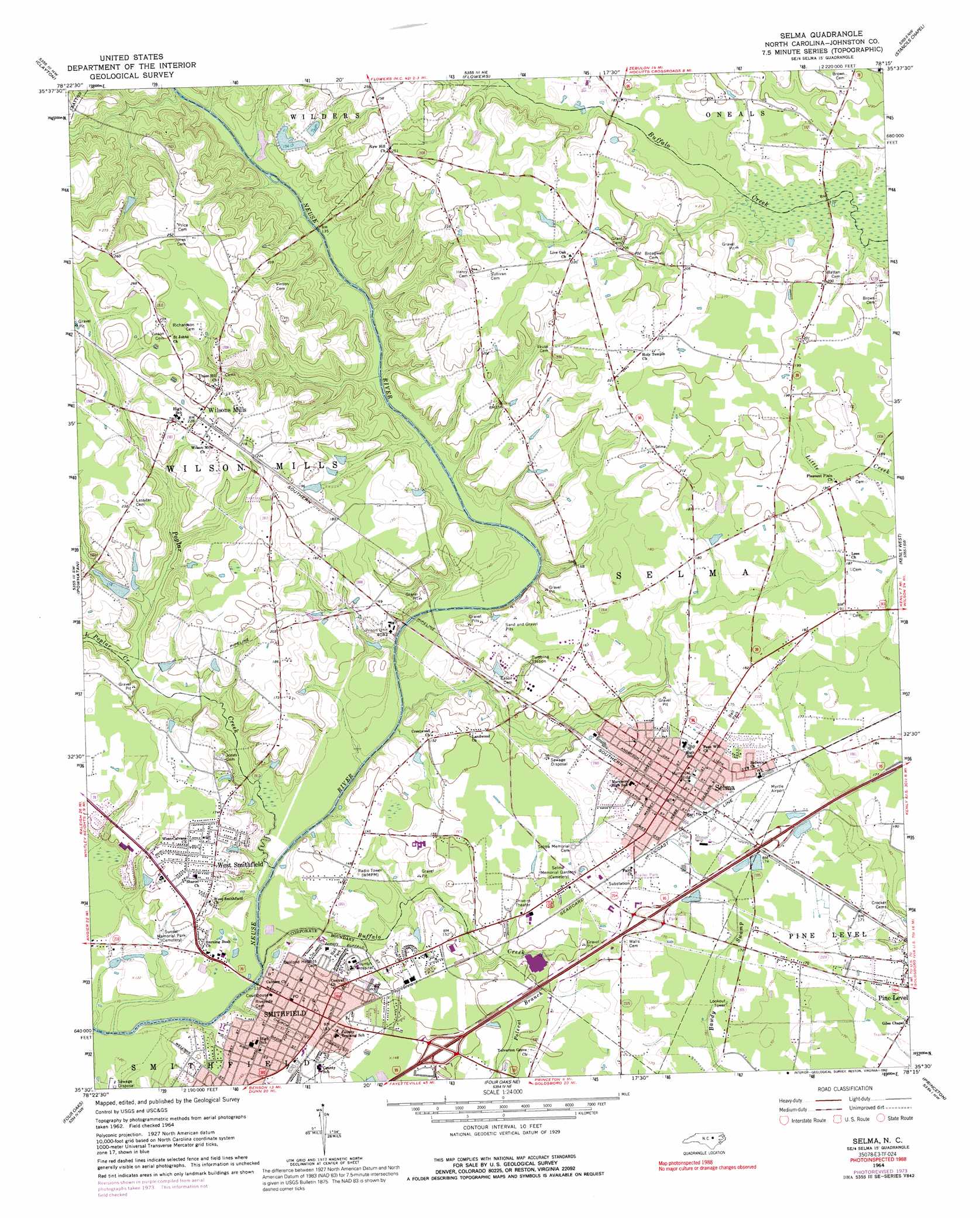
Selma Topo Map North Carolina
To zoom in, hover over the map of Selma
USGS Topo Quad 35078e3 - 1:24,000 scale
| Topo Map Name: | Selma |
| USGS Topo Quad ID: | 35078e3 |
| Print Size: | ca. 21 1/4" wide x 27" high |
| Southeast Coordinates: | 35.5° N latitude / 78.25° W longitude |
| Map Center Coordinates: | 35.5625° N latitude / 78.3125° W longitude |
| U.S. State: | NC |
| Filename: | o35078e3.jpg |
| Download Map JPG Image: | Selma topo map 1:24,000 scale |
| Map Type: | Topographic |
| Topo Series: | 7.5´ |
| Map Scale: | 1:24,000 |
| Source of Map Images: | United States Geological Survey (USGS) |
| Alternate Map Versions: |
Selma NC 1964, updated 1965 Download PDF Buy paper map Selma NC 1964, updated 1976 Download PDF Buy paper map Selma NC 1964, updated 1992 Download PDF Buy paper map Selma NC 1998, updated 2000 Download PDF Buy paper map Selma NC 2010 Download PDF Buy paper map Selma NC 2013 Download PDF Buy paper map Selma NC 2016 Download PDF Buy paper map |
1:24,000 Topo Quads surrounding Selma
Raleigh East |
Knightdale |
Zebulon |
Middlesex |
Bailey |
Garner |
Clayton |
Flowers |
Stancils Chapel |
Lucama |
Edmondson |
Powhatan |
Selma |
Kenly West |
Kenly East |
Benson |
Four Oaks |
Four Oaks Ne |
Princeton |
Northwest Goldsboro |
Dunn |
Peacocks Crossroads |
Newton Grove North |
Grantham |
Southwest Goldsboro |
> Back to 35078e1 at 1:100,000 scale
> Back to 35078a1 at 1:250,000 scale
> Back to U.S. Topo Maps home
Selma topo map: Gazetteer
Selma: Airports
Selma Airport elevation 51m 167′Selma: Dams
Johnston County Wildlife Pond Dam elevation 48m 157′Uzzles Pond Dam elevation 80m 262′
Selma: Parks
Sunset Memorial Park elevation 43m 141′Selma: Populated Places
Castlehaven elevation 46m 150′Eden Woods elevation 46m 150′
Fairfield elevation 42m 137′
Laurelwood Hills elevation 49m 160′
Noble Hills elevation 51m 167′
Old Farm Acres elevation 53m 173′
Redwood Village elevation 53m 173′
Rose Manor elevation 44m 144′
Selma elevation 53m 173′
Smithfield elevation 45m 147′
Sunrise Acres elevation 51m 167′
West Smithfield elevation 47m 154′
Westview elevation 45m 147′
Wilsons Mills elevation 70m 229′
Selma: Reservoirs
Johnson County Wildlife Pond elevation 48m 157′Uzzles Pond elevation 80m 262′
Selma: Streams
Buffalo Creek elevation 32m 104′Little Poplar Creek elevation 41m 134′
Poplar Creek elevation 33m 108′
Selma digital topo map on disk
Buy this Selma topo map showing relief, roads, GPS coordinates and other geographical features, as a high-resolution digital map file on DVD:
South Carolina, Western North Carolina & Northeastern Georgia
Buy digital topo maps: South Carolina, Western North Carolina & Northeastern Georgia