Angier Topo Map North Carolina
To zoom in, hover over the map of Angier
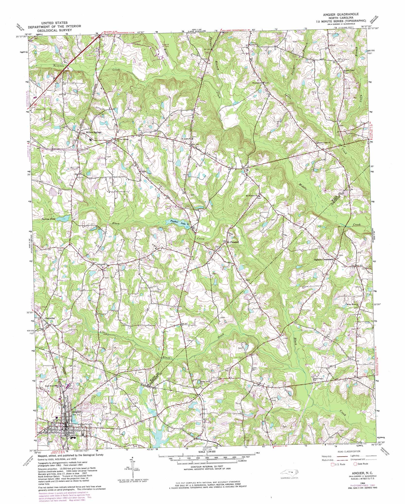
USGS Topo Quad 35078e6 - 1:24,000 scale
| Topo Map Name: | Angier |
| USGS Topo Quad ID: | 35078e6 |
| Print Size: | ca. 21 1/4" wide x 27" high |
| Southeast Coordinates: | 35.5° N latitude / 78.625° W longitude |
| Map Center Coordinates: | 35.5625° N latitude / 78.6875° W longitude |
| U.S. State: | NC |
| Filename: | o35078e6.jpg |
| Download Map JPG Image: | Angier topo map 1:24,000 scale |
| Map Type: | Topographic |
| Topo Series: | 7.5´ |
| Map Scale: | 1:24,000 |
| Source of Map Images: | United States Geological Survey (USGS) |
| Alternate Map Versions: |
Angier NC 1964, updated 1965 Download PDF Buy paper map Angier NC 1964, updated 1975 Download PDF Buy paper map Angier NC 1964, updated 1982 Download PDF Buy paper map Angier NC 1993, updated 1998 Download PDF Buy paper map Angier NC 2010 Download PDF Buy paper map Angier NC 2013 Download PDF Buy paper map Angier NC 2016 Download PDF Buy paper map |
1:24,000 Topo Quads surrounding Angier
Green Level |
Cary |
Raleigh West |
Raleigh East |
Knightdale |
New Hill |
Apex |
Lake Wheeler |
Garner |
Clayton |
Cokesbury |
Fuquay-Varina |
Angier |
Edmondson |
Powhatan |
Mamers |
Lillington |
Coats |
Benson |
Four Oaks |
Anderson Creek |
Bunnlevel |
Erwin |
Dunn |
Peacocks Crossroads |
> Back to 35078e1 at 1:100,000 scale
> Back to 35078a1 at 1:250,000 scale
> Back to U.S. Topo Maps home
Angier topo map: Gazetteer
Angier: Airports
Fuquay-Angier Field elevation 103m 337′Triple W Air Park elevation 76m 249′
Angier: Dams
Johnson Pond Dam elevation 98m 321′Julians Lake Dam elevation 83m 272′
Panther Lake Dam elevation 78m 255′
Partins Pond Dam elevation 92m 301′
Powell Lake Dam elevation 103m 337′
Saunders Lake Dam elevation 102m 334′
W I Rowland Pond Dam elevation 94m 308′
Youngs Pond Dam elevation 75m 246′
Angier: Populated Places
Angier elevation 89m 291′Kennebec elevation 105m 344′
Mount Pleasant elevation 92m 301′
Ogburn Crossroads elevation 90m 295′
Willow Springs elevation 109m 357′
Angier: Post Offices
Willow Spring Post Office elevation 114m 374′Angier: Reservoirs
Johnson Pond elevation 98m 321′Julians Lake elevation 83m 272′
Panther Lake elevation 78m 255′
Partins Pond elevation 92m 301′
Powell Lake elevation 103m 337′
Saunders Lake elevation 102m 334′
W I Rowland Pond elevation 94m 308′
Youngs Pond elevation 75m 246′
Angier: Streams
Ditch Branch elevation 72m 236′Guffy Branch elevation 70m 229′
Juniper Branch elevation 79m 259′
Little Black Creek elevation 56m 183′
Panther Branch elevation 70m 229′
Terrible Creek elevation 71m 232′
Angier digital topo map on disk
Buy this Angier topo map showing relief, roads, GPS coordinates and other geographical features, as a high-resolution digital map file on DVD:
South Carolina, Western North Carolina & Northeastern Georgia
Buy digital topo maps: South Carolina, Western North Carolina & Northeastern Georgia