Stancils Chapel Topo Map North Carolina
To zoom in, hover over the map of Stancils Chapel
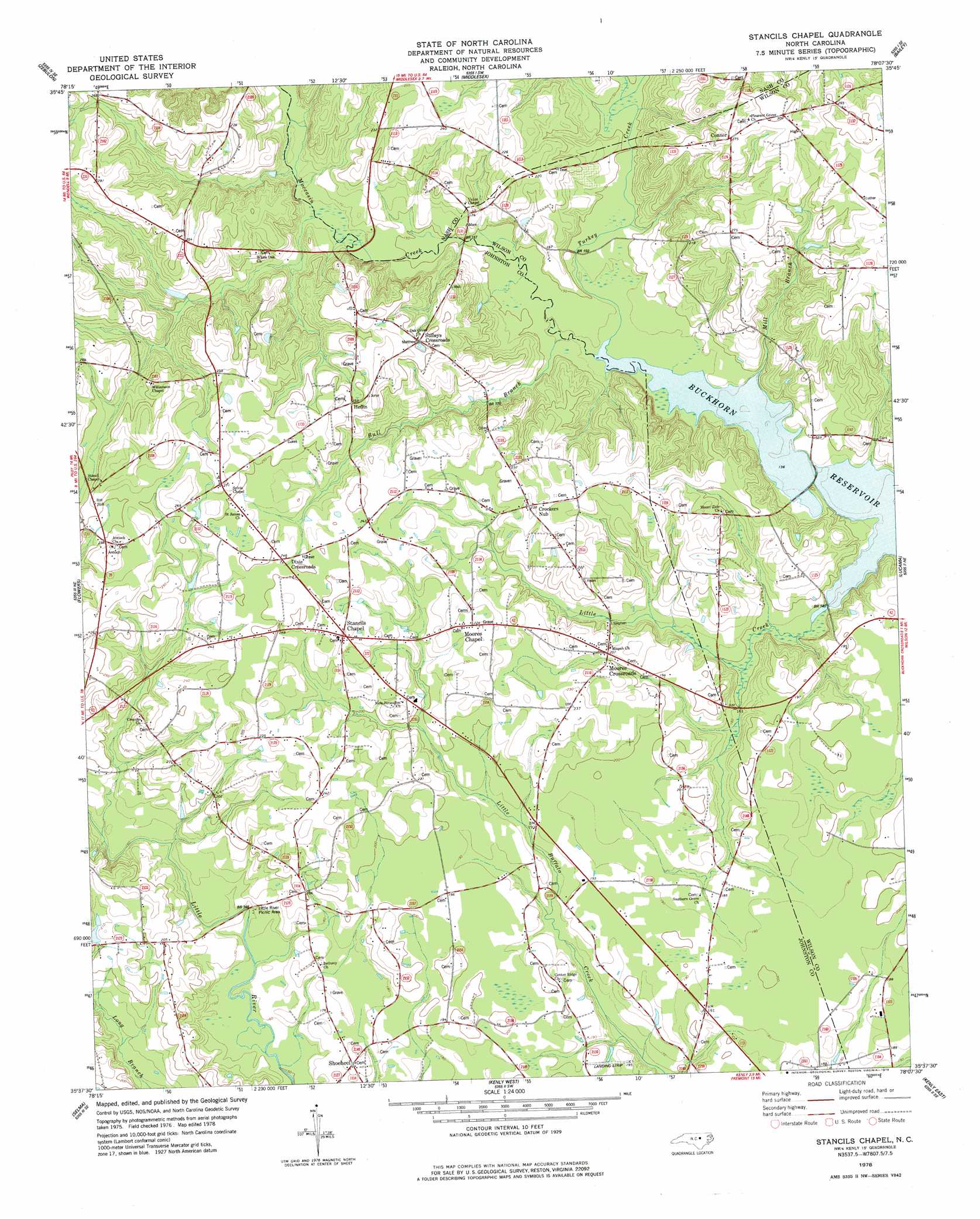
USGS Topo Quad 35078f2 - 1:24,000 scale
| Topo Map Name: | Stancils Chapel |
| USGS Topo Quad ID: | 35078f2 |
| Print Size: | ca. 21 1/4" wide x 27" high |
| Southeast Coordinates: | 35.625° N latitude / 78.125° W longitude |
| Map Center Coordinates: | 35.6875° N latitude / 78.1875° W longitude |
| U.S. State: | NC |
| Filename: | o35078f2.jpg |
| Download Map JPG Image: | Stancils Chapel topo map 1:24,000 scale |
| Map Type: | Topographic |
| Topo Series: | 7.5´ |
| Map Scale: | 1:24,000 |
| Source of Map Images: | United States Geological Survey (USGS) |
| Alternate Map Versions: |
Stancils Chapel NC 1978, updated 1978 Download PDF Buy paper map Stancils Chapel NC 2010 Download PDF Buy paper map Stancils Chapel NC 2013 Download PDF Buy paper map Stancils Chapel NC 2016 Download PDF Buy paper map |
1:24,000 Topo Quads surrounding Stancils Chapel
Rolesville |
Bunn West |
Bunn East |
Spring Hope |
Nashville |
Knightdale |
Zebulon |
Middlesex |
Bailey |
Winstead Crossroads |
Clayton |
Flowers |
Stancils Chapel |
Lucama |
Wilson |
Powhatan |
Selma |
Kenly West |
Kenly East |
Fremont |
Four Oaks |
Four Oaks Ne |
Princeton |
Northwest Goldsboro |
Northeast Goldsboro |
> Back to 35078e1 at 1:100,000 scale
> Back to 35078a1 at 1:250,000 scale
> Back to U.S. Topo Maps home
Stancils Chapel topo map: Gazetteer
Stancils Chapel: Bridges
Evans Bridge elevation 45m 147′Stancils Chapel: Parks
Little River Picnic Area elevation 50m 164′Stancils Chapel: Populated Places
Connor elevation 83m 272′Crockers Nub elevation 73m 239′
Dixie Crossroads elevation 75m 246′
Heflin elevation 76m 249′
Moores Chapel elevation 69m 226′
Moores Crossroads elevation 63m 206′
Shoeheel elevation 55m 180′
Stancils Chapel elevation 73m 239′
Stilleys Crossroads elevation 75m 246′
Stancils Chapel: Streams
Beaverdam Creek elevation 45m 147′Bull Branch elevation 44m 144′
Little Creek elevation 44m 144′
Mill Branch elevation 44m 144′
Moccasin Creek elevation 44m 144′
Turkey Creek elevation 44m 144′
Stancils Chapel: Swamps
Lamms Pond elevation 48m 157′Stancils Chapel digital topo map on disk
Buy this Stancils Chapel topo map showing relief, roads, GPS coordinates and other geographical features, as a high-resolution digital map file on DVD:
South Carolina, Western North Carolina & Northeastern Georgia
Buy digital topo maps: South Carolina, Western North Carolina & Northeastern Georgia