Apex Topo Map North Carolina
To zoom in, hover over the map of Apex
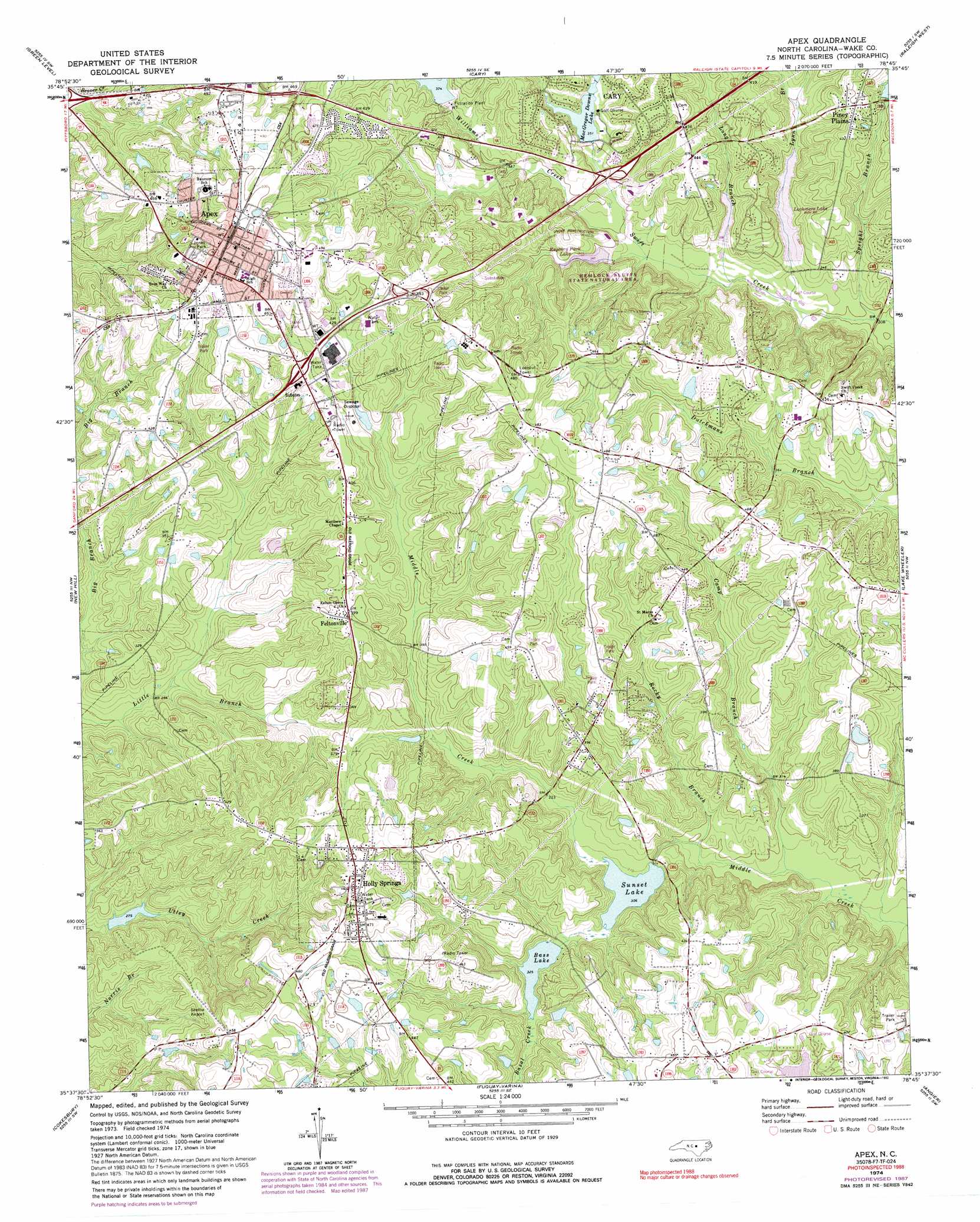
USGS Topo Quad 35078f7 - 1:24,000 scale
| Topo Map Name: | Apex |
| USGS Topo Quad ID: | 35078f7 |
| Print Size: | ca. 21 1/4" wide x 27" high |
| Southeast Coordinates: | 35.625° N latitude / 78.75° W longitude |
| Map Center Coordinates: | 35.6875° N latitude / 78.8125° W longitude |
| U.S. State: | NC |
| Filename: | o35078f7.jpg |
| Download Map JPG Image: | Apex topo map 1:24,000 scale |
| Map Type: | Topographic |
| Topo Series: | 7.5´ |
| Map Scale: | 1:24,000 |
| Source of Map Images: | United States Geological Survey (USGS) |
| Alternate Map Versions: |
Apex NC 1974, updated 1977 Download PDF Buy paper map Apex NC 1974, updated 1982 Download PDF Buy paper map Apex NC 1974, updated 1987 Download PDF Buy paper map Apex NC 1974, updated 1992 Download PDF Buy paper map Apex NC 1974, updated 1992 Download PDF Buy paper map Apex NC 1993, updated 1999 Download PDF Buy paper map Apex NC 2002, updated 2004 Download PDF Buy paper map Apex NC 2010 Download PDF Buy paper map Apex NC 2013 Download PDF Buy paper map Apex NC 2016 Download PDF Buy paper map |
1:24,000 Topo Quads surrounding Apex
Chapel Hill |
Southwest Durham |
Southeast Durham |
Bayleaf |
Wake Forest |
Farrington |
Green Level |
Cary |
Raleigh West |
Raleigh East |
Merry Oaks |
New Hill |
Apex |
Lake Wheeler |
Garner |
Moncure |
Cokesbury |
Fuquay-Varina |
Angier |
Edmondson |
Broadway |
Mamers |
Lillington |
Coats |
Benson |
> Back to 35078e1 at 1:100,000 scale
> Back to 35078a1 at 1:250,000 scale
> Back to U.S. Topo Maps home
Apex topo map: Gazetteer
Apex: Airports
Shelba Field elevation 128m 419′Apex: Dams
Akins Pond Number One Dam elevation 126m 413′Akins Pond Number Two Dam elevation 123m 403′
Apex Lake Dam elevation 127m 416′
Bass Lake Dam elevation 94m 308′
Grey Pond Dam elevation 124m 406′
McGregor Downs Lake Dam elevation 122m 400′
Sunset Lake Dam elevation 93m 305′
Apex: Parks
Hemlock Bluffs State Natural Area elevation 126m 413′Jones Park elevation 140m 459′
Regency Park elevation 129m 423′
Apex: Populated Places
Apex elevation 152m 498′Clairmont elevation 152m 498′
Claybourne elevation 121m 396′
Damont Hills elevation 150m 492′
Feltonville elevation 121m 396′
Holly Springs elevation 134m 439′
Indian Trail elevation 135m 442′
Irongate elevation 130m 426′
Justice Heights elevation 122m 400′
Knollwood elevation 113m 370′
MacGregor Downs elevation 126m 413′
MacGregor Park elevation 108m 354′
Pinewood Acres elevation 143m 469′
Piney Plains elevation 136m 446′
Shangri-La Mobile Home Park elevation 131m 429′
Summerwinds elevation 111m 364′
Waverly Place elevation 125m 410′
Wellington Park elevation 111m 364′
Apex: Post Offices
Apex Post Office elevation 138m 452′Apex: Reservoirs
Akins Pond Number One elevation 126m 413′Akins Pond Number Two elevation 123m 403′
Apex Lake elevation 127m 416′
Bass Lake elevation 94m 308′
Grey Pond elevation 124m 406′
MacGregor Downs Lake elevation 106m 347′
McGregor Downs Lake elevation 122m 400′
Sunset Lake elevation 93m 305′
Apex: Streams
Basal Creek elevation 99m 324′Camp Branch elevation 87m 285′
Long Branch elevation 96m 314′
Lynn Branch elevation 93m 305′
Rocky Branch elevation 89m 291′
Speight Branch elevation 91m 298′
Williams Creek elevation 98m 321′
Apex digital topo map on disk
Buy this Apex topo map showing relief, roads, GPS coordinates and other geographical features, as a high-resolution digital map file on DVD:
South Carolina, Western North Carolina & Northeastern Georgia
Buy digital topo maps: South Carolina, Western North Carolina & Northeastern Georgia