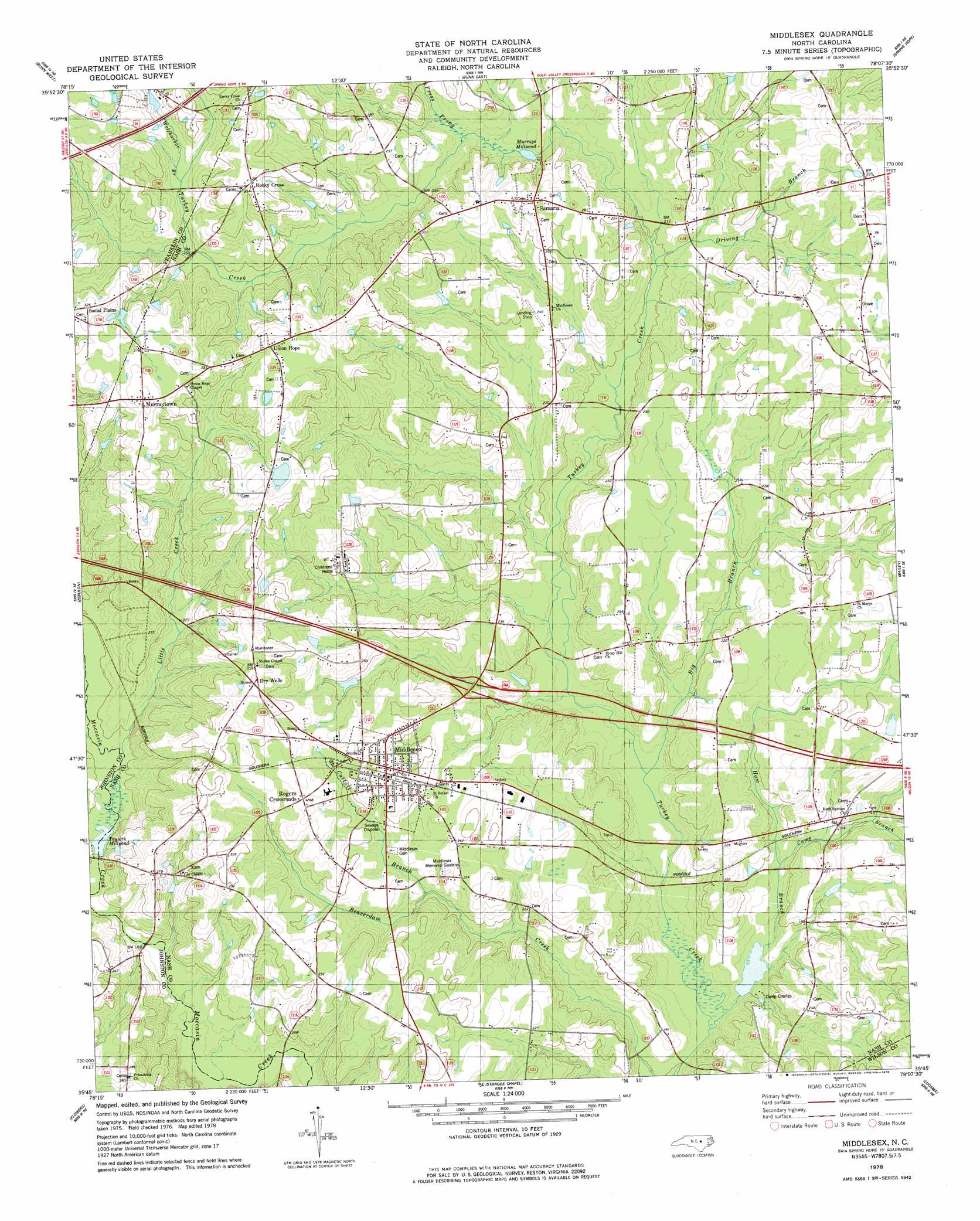
Middlesex Topo Map North Carolina
To zoom in, hover over the map of Middlesex
USGS Topo Quad 35078g2 - 1:24,000 scale
| Topo Map Name: | Middlesex |
| USGS Topo Quad ID: | 35078g2 |
| Print Size: | ca. 21 1/4" wide x 27" high |
| Southeast Coordinates: | 35.75° N latitude / 78.125° W longitude |
| Map Center Coordinates: | 35.8125° N latitude / 78.1875° W longitude |
| U.S. State: | NC |
| Filename: | o35078g2.jpg |
| Download Map JPG Image: | Middlesex topo map 1:24,000 scale |
| Map Type: | Topographic |
| Topo Series: | 7.5´ |
| Map Scale: | 1:24,000 |
| Source of Map Images: | United States Geological Survey (USGS) |
| Alternate Map Versions: |
Middlesex NC 1978, updated 1978 Download PDF Buy paper map Middlesex NC 2010 Download PDF Buy paper map Middlesex NC 2013 Download PDF Buy paper map Middlesex NC 2016 Download PDF Buy paper map |
1:24,000 Topo Quads surrounding Middlesex
Franklinton |
Louisburg |
Justice |
Castalia |
Red Oak |
Rolesville |
Bunn West |
Bunn East |
Spring Hope |
Nashville |
Knightdale |
Zebulon |
Middlesex |
Bailey |
Winstead Crossroads |
Clayton |
Flowers |
Stancils Chapel |
Lucama |
Wilson |
Powhatan |
Selma |
Kenly West |
Kenly East |
Fremont |
> Back to 35078e1 at 1:100,000 scale
> Back to 35078a1 at 1:250,000 scale
> Back to U.S. Topo Maps home
Middlesex topo map: Gazetteer
Middlesex: Airports
JW Stone Airport elevation 77m 252′Middlesex: Bridges
Chamblees Bridge elevation 72m 236′Cone Bridge elevation 70m 229′
Creech Bridge elevation 56m 183′
Wilder Bridge elevation 51m 167′
Middlesex: Dams
Camp Charles Lake Dam elevation 48m 157′Corbetts Pond Number One Dam elevation 73m 239′
Murrays Pond Dam elevation 64m 209′
Taylors Millpond Dam elevation 57m 187′
Middlesex: Populated Places
Middlesex elevation 80m 262′Murraytown elevation 103m 337′
Old Stanhope (historical) elevation 89m 291′
Rocky Cross elevation 96m 314′
Rogers Crossroads elevation 88m 288′
Samaria elevation 83m 272′
Social Plains elevation 99m 324′
Union Hope elevation 95m 311′
Middlesex: Reservoirs
Camp Charles Lake elevation 48m 157′Corbetts Pond Number One elevation 73m 239′
Murrays Millpond elevation 64m 209′
Taylors Millpond elevation 57m 187′
Middlesex: Streams
Big Branch elevation 49m 160′Camp Branch elevation 51m 167′
Cattail Branch elevation 61m 200′
Driving Branch elevation 60m 196′
Haw Branch elevation 46m 150′
Little Creek elevation 59m 193′
Press Prong elevation 66m 216′
Wolfharbor Branch elevation 77m 252′
Middlesex digital topo map on disk
Buy this Middlesex topo map showing relief, roads, GPS coordinates and other geographical features, as a high-resolution digital map file on DVD:
South Carolina, Western North Carolina & Northeastern Georgia
Buy digital topo maps: South Carolina, Western North Carolina & Northeastern Georgia