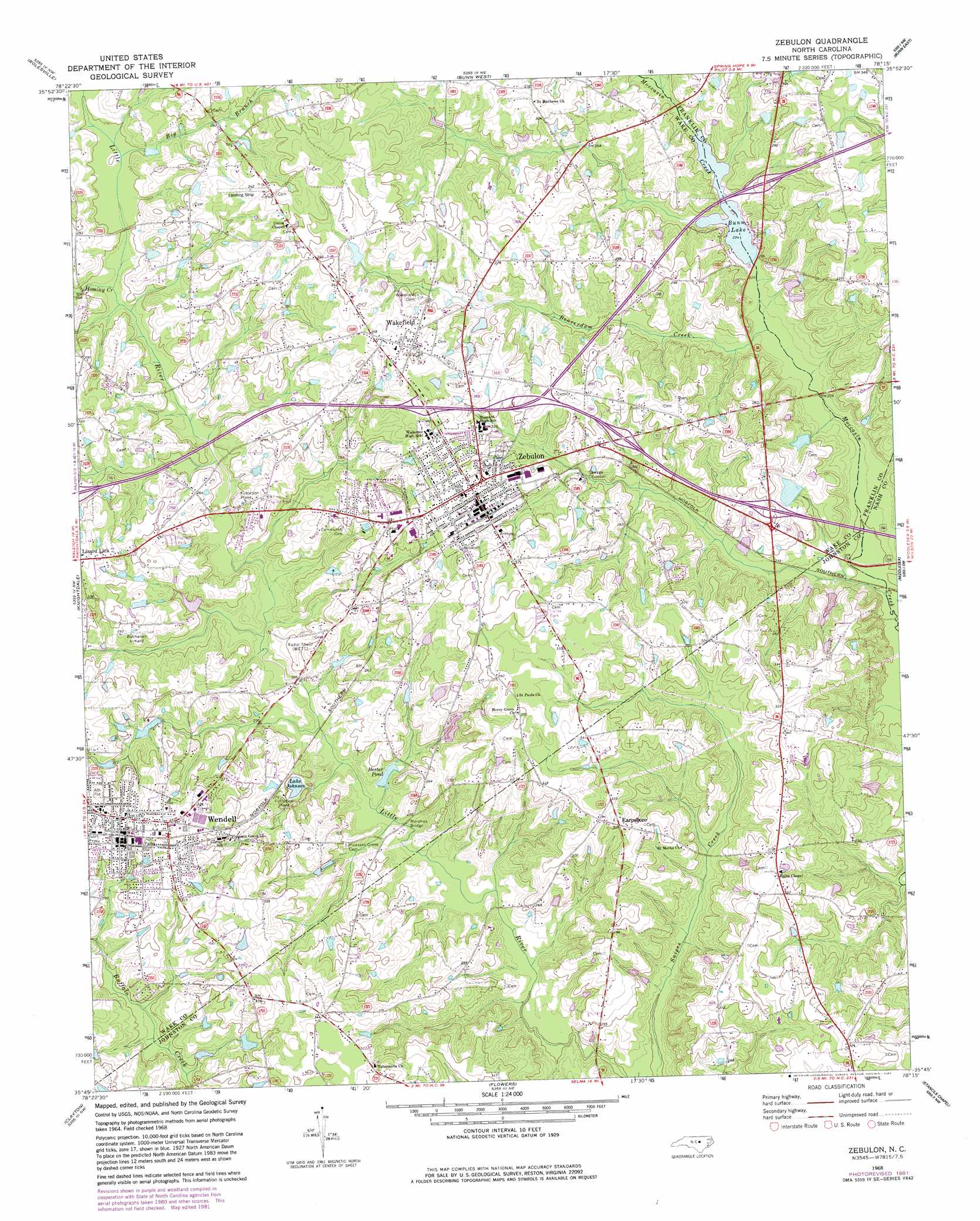
Zebulon Topo Map North Carolina
To zoom in, hover over the map of Zebulon
USGS Topo Quad 35078g3 - 1:24,000 scale
| Topo Map Name: | Zebulon |
| USGS Topo Quad ID: | 35078g3 |
| Print Size: | ca. 21 1/4" wide x 27" high |
| Southeast Coordinates: | 35.75° N latitude / 78.25° W longitude |
| Map Center Coordinates: | 35.8125° N latitude / 78.3125° W longitude |
| U.S. State: | NC |
| Filename: | o35078g3.jpg |
| Download Map JPG Image: | Zebulon topo map 1:24,000 scale |
| Map Type: | Topographic |
| Topo Series: | 7.5´ |
| Map Scale: | 1:24,000 |
| Source of Map Images: | United States Geological Survey (USGS) |
| Alternate Map Versions: |
Zebulon NC 1968, updated 1972 Download PDF Buy paper map Zebulon NC 1968, updated 1975 Download PDF Buy paper map Zebulon NC 1968, updated 1982 Download PDF Buy paper map Zebulon NC 1999, updated 2000 Download PDF Buy paper map Zebulon NC 2010 Download PDF Buy paper map Zebulon NC 2013 Download PDF Buy paper map Zebulon NC 2016 Download PDF Buy paper map |
1:24,000 Topo Quads surrounding Zebulon
Grissom |
Franklinton |
Louisburg |
Justice |
Castalia |
Wake Forest |
Rolesville |
Bunn West |
Bunn East |
Spring Hope |
Raleigh East |
Knightdale |
Zebulon |
Middlesex |
Bailey |
Garner |
Clayton |
Flowers |
Stancils Chapel |
Lucama |
Edmondson |
Powhatan |
Selma |
Kenly West |
Kenly East |
> Back to 35078e1 at 1:100,000 scale
> Back to 35078a1 at 1:250,000 scale
> Back to U.S. Topo Maps home
Zebulon topo map: Gazetteer
Zebulon: Airports
Buchanan Airport elevation 86m 282′Hendricks Ranch Airport elevation 96m 314′
Zebulon Airport elevation 103m 337′
Zebulon: Bridges
Morphus Bridge elevation 67m 219′Zebulon: Dams
Ammons Pond Dam elevation 79m 259′Bunn Lake Dam elevation 71m 232′
Hendricks Dam elevation 99m 324′
Hester Pond Dam elevation 65m 213′
Lu-Tom Acres Lake Dam elevation 81m 265′
Moss Pond Dam elevation 83m 272′
Privette Lake Number One Dam elevation 81m 265′
Privette Pond Number Two Dam elevation 68m 223′
Zebulon: Populated Places
Angelview elevation 86m 282′Cobblestone elevation 84m 275′
Deerfield elevation 96m 314′
Earpsboro elevation 92m 301′
Lizard Lick elevation 101m 331′
Pineview Estates elevation 87m 285′
Rivercrest elevation 85m 278′
Wedgewood elevation 89m 291′
Wendell elevation 97m 318′
Zebulon elevation 98m 321′
Zebulon: Reservoirs
Ammons Pond elevation 79m 259′Bunn Lake elevation 71m 232′
Hendricks Pond elevation 99m 324′
Hester Pond elevation 65m 213′
Lake Johnson elevation 77m 252′
Lu-Tom Acres Lake elevation 81m 265′
Moss Pond elevation 83m 272′
Privette Lake Number One elevation 81m 265′
Privette Pond Number Two elevation 68m 223′
Tarpleys Pond elevation 67m 219′
Zebulon: Streams
Beaverdam Creek elevation 67m 219′Big Branch elevation 75m 246′
Fall Branch elevation 72m 236′
Hominy Creek elevation 74m 242′
Little Creek elevation 61m 200′
Rocky Branch elevation 73m 239′
Zebulon digital topo map on disk
Buy this Zebulon topo map showing relief, roads, GPS coordinates and other geographical features, as a high-resolution digital map file on DVD:
South Carolina, Western North Carolina & Northeastern Georgia
Buy digital topo maps: South Carolina, Western North Carolina & Northeastern Georgia