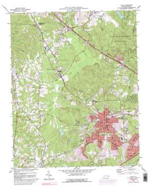
Cary Topo Map North Carolina
To zoom in, hover over the map of Cary
USGS Topo Quad 35078g7 - 1:24,000 scale
| Topo Map Name: | Cary |
| USGS Topo Quad ID: | 35078g7 |
| Print Size: | ca. 21 1/4" wide x 27" high |
| Southeast Coordinates: | 35.75° N latitude / 78.75° W longitude |
| Map Center Coordinates: | 35.8125° N latitude / 78.8125° W longitude |
| U.S. State: | NC |
| Filename: | o35078g7.jpg |
| Download Map JPG Image: | Cary topo map 1:24,000 scale |
| Map Type: | Topographic |
| Topo Series: | 7.5´ |
| Map Scale: | 1:24,000 |
| Source of Map Images: | United States Geological Survey (USGS) |
| Alternate Map Versions: |
Cary NC 1973, updated 1975 Download PDF Buy paper map Cary NC 1973, updated 1982 Download PDF Buy paper map Cary NC 1973, updated 1987 Download PDF Buy paper map Cary NC 1973, updated 1992 Download PDF Buy paper map Cary NC 1973, updated 1992 Download PDF Buy paper map Cary NC 1993, updated 1999 Download PDF Buy paper map Cary NC 2010 Download PDF Buy paper map Cary NC 2013 Download PDF Buy paper map Cary NC 2016 Download PDF Buy paper map |
1:24,000 Topo Quads surrounding Cary
> Back to 35078e1 at 1:100,000 scale
> Back to 35078a1 at 1:250,000 scale
> Back to U.S. Topo Maps home
Cary topo map: Gazetteer
Cary: Airports
Cox Airport elevation 134m 439′Raleigh-Durham Airport elevation 130m 426′
Cary: Crossings
Interchange 283 elevation 104m 341′Interchange 284A and 284B elevation 92m 301′
Interchange 285 elevation 102m 334′
Interchange 287 elevation 126m 413′
Cary: Dams
Continental Can Company Lake Dam elevation 104m 341′Crabtree Creek W/S Number Eighteen Dam elevation 99m 324′
Crabtree Creek W/S Structure Number Two Dam elevation 103m 337′
Hatches Pond Dam elevation 105m 344′
Hoffman Lake Dam elevation 115m 377′
Holiday Acres Lake Dam elevation 128m 419′
Umstead Park Lake Lower Dam elevation 97m 318′
Umstead Park Lake Upper Dam elevation 101m 331′
Cary: Lakes
Lake Crabtree elevation 84m 275′Cary: Parks
Fred G Bond Metro Park elevation 112m 367′Cary: Populated Places
Beechtree elevation 118m 387′Blackhawk elevation 129m 423′
Brookstone elevation 114m 374′
Burtrose elevation 154m 505′
Cambridge Forest elevation 126m 413′
Carpenter elevation 119m 390′
Cary elevation 151m 495′
Cedar Creek elevation 133m 436′
Churchill Downs elevation 133m 436′
Clegg elevation 118m 387′
Dublin Woods elevation 138m 452′
Dutchess Village elevation 121m 396′
Edgehill Farms elevation 135m 442′
Farmington Woods elevation 139m 456′
Greenwood Acres elevation 149m 488′
Hazelwood elevation 121m 396′
Hearthstone Farms elevation 146m 479′
Highland Park elevation 150m 492′
Hillsdale Forest elevation 137m 449′
Homestead Estates elevation 137m 449′
Irongate elevation 142m 465′
Ivy Meadows elevation 140m 459′
Kilarney Woods elevation 133m 436′
Kildaire Farms elevation 130m 426′
Lochaven elevation 142m 465′
MacDonald Woods elevation 120m 393′
Medfield Estates elevation 137m 449′
Morrisville elevation 92m 301′
Northwoods elevation 134m 439′
Oxxford Hunt elevation 118m 387′
Parkway elevation 126m 413′
Pirates Cove elevation 135m 442′
Plantation Estates elevation 141m 462′
Preston elevation 96m 314′
Rainbow Estates elevation 149m 488′
Russell Hills elevation 144m 472′
Savon Height elevation 140m 459′
Silverton elevation 131m 429′
Stoneybrook elevation 144m 472′
Trappers Run elevation 126m 413′
Upchurch elevation 131m 429′
Weston elevation 95m 311′
Westpark Place elevation 105m 344′
Willoughby Place elevation 138m 452′
Wimbledon elevation 130m 426′
Wishing Well elevation 132m 433′
Cary: Post Offices
Cary Post Office elevation 154m 505′Morrisville Post Office elevation 114m 374′
Cary: Reservoirs
Brier Creek Reservoir elevation 96m 314′Continental Can Company Lake elevation 104m 341′
Crabtree Creek W/S Number Eighteen elevation 99m 324′
Crabtree Creek Water Shed elevation 103m 337′
Hatchs Pond elevation 105m 344′
Hoffman Lake elevation 115m 377′
Holiday Acres Lake elevation 128m 419′
Umstead Park Lake Upper elevation 101m 331′
Umstead Park Lower Lake elevation 97m 318′
Cary: Streams
Brier Creek elevation 84m 275′Coles Branch elevation 93m 305′
Haleys Branch elevation 83m 272′
Pots Branch elevation 97m 318′
Stirrup Iron Creek elevation 83m 272′
Turkey Creek elevation 93m 305′
Cary digital topo map on disk
Buy this Cary topo map showing relief, roads, GPS coordinates and other geographical features, as a high-resolution digital map file on DVD:
South Carolina, Western North Carolina & Northeastern Georgia
Buy digital topo maps: South Carolina, Western North Carolina & Northeastern Georgia


