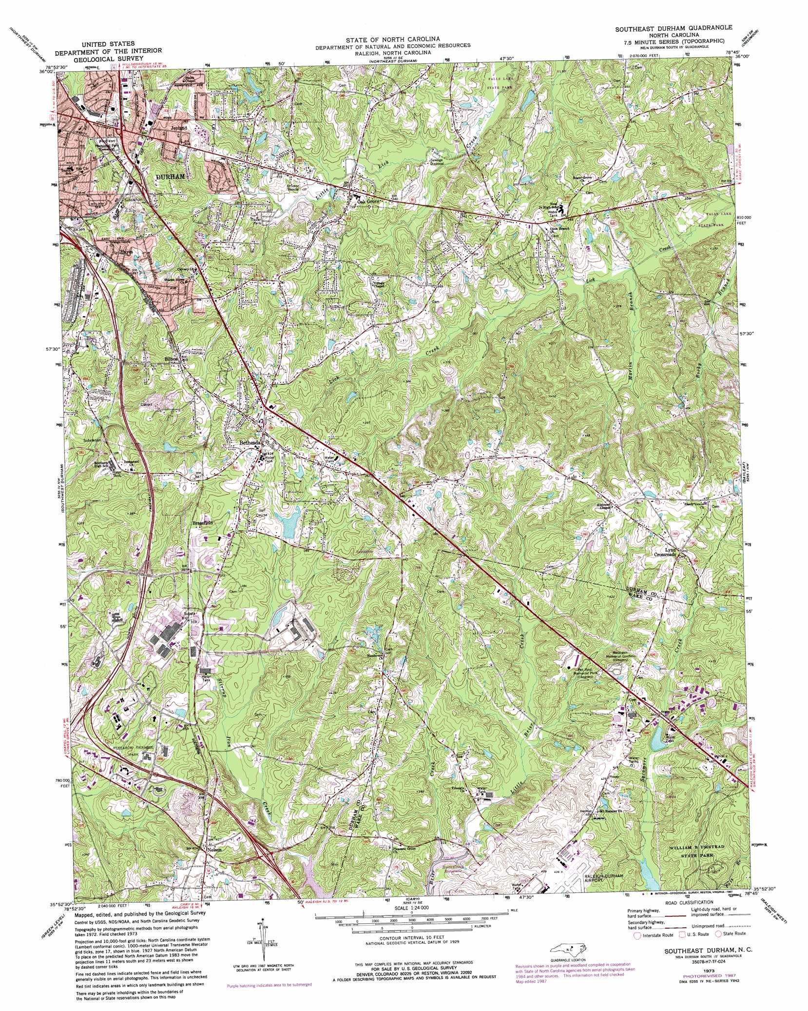
Southeast Durham Topo Map North Carolina
To zoom in, hover over the map of Southeast Durham
USGS Topo Quad 35078h7 - 1:24,000 scale
| Topo Map Name: | Southeast Durham |
| USGS Topo Quad ID: | 35078h7 |
| Print Size: | ca. 21 1/4" wide x 27" high |
| Southeast Coordinates: | 35.875° N latitude / 78.75° W longitude |
| Map Center Coordinates: | 35.9375° N latitude / 78.8125° W longitude |
| U.S. State: | NC |
| Filename: | o35078h7.jpg |
| Download Map JPG Image: | Southeast Durham topo map 1:24,000 scale |
| Map Type: | Topographic |
| Topo Series: | 7.5´ |
| Map Scale: | 1:24,000 |
| Source of Map Images: | United States Geological Survey (USGS) |
| Alternate Map Versions: |
Southeast Durham NC 1973, updated 1982 Download PDF Buy paper map Southeast Durham NC 1973, updated 1987 Download PDF Buy paper map Southeast Durham NC 1993, updated 1998 Download PDF Buy paper map Southeast Durham NC 2010 Download PDF Buy paper map Southeast Durham NC 2013 Download PDF Buy paper map Southeast Durham NC 2016 Download PDF Buy paper map |
1:24,000 Topo Quads surrounding Southeast Durham
Caldwell |
Rougemont |
Lake Michie |
Stem |
Wilton |
Hillsborough |
Northwest Durham |
Northeast Durham |
Creedmoor |
Grissom |
Chapel Hill |
Southwest Durham |
Southeast Durham |
Bayleaf |
Wake Forest |
Farrington |
Green Level |
Cary |
Raleigh West |
Raleigh East |
Merry Oaks |
New Hill |
Apex |
Lake Wheeler |
Garner |
> Back to 35078e1 at 1:100,000 scale
> Back to 35078a1 at 1:250,000 scale
> Back to U.S. Topo Maps home
Southeast Durham topo map: Gazetteer
Southeast Durham: Crossings
Interchange 1A elevation 106m 347′Interchange 1B elevation 103m 337′
Interchange 2 elevation 111m 364′
Interchange 280 elevation 97m 318′
Interchange 281 elevation 118m 387′
Interchange 282 elevation 113m 370′
Interchange 3 elevation 104m 341′
Interchange 4A elevation 119m 390′
Interchange 4B elevation 124m 406′
Southeast Durham: Dams
Allen Lake Dam elevation 100m 328′Angus Barn Pond Dam elevation 111m 364′
Bailey Lake Dam elevation 86m 282′
Chandler Lake Dam elevation 96m 314′
Crabtree Creek W/S Structure Number One Dam elevation 93m 305′
General Electric Number Two Dam elevation 105m 344′
Kings Pond Dam elevation 93m 305′
Lake Shore Dam elevation 110m 360′
Twin Lake Number One Dam elevation 98m 321′
Twin Lake Number Two Dam elevation 100m 328′
Southeast Durham: Parks
Research Triangle Park elevation 93m 305′Southeast Durham: Populated Places
Bethesda elevation 128m 419′Bilboa elevation 123m 403′
Brassfield elevation 114m 374′
Hayes elevation 120m 393′
Joyland elevation 120m 393′
Lynn Crossroads elevation 143m 469′
Nelson elevation 125m 410′
Oak Grove elevation 97m 318′
Southeast Durham: Post Offices
East Durham Post Office elevation 103m 337′Southeast Durham: Reservoirs
Allen Lake elevation 100m 328′Angus Barn Pond elevation 111m 364′
Bailey Lake elevation 86m 282′
Chandler Lake elevation 96m 314′
Crabtree Creek W/S elevation 93m 305′
General Electric Lake Number Two elevation 105m 344′
Kings Pond elevation 93m 305′
Lake Shore elevation 110m 360′
Twin Lake Number One elevation 98m 321′
Twin Lake Number Two elevation 100m 328′
Southeast Durham: Streams
Little Brier Creek elevation 93m 305′Martin Branch elevation 85m 278′
Southeast Durham digital topo map on disk
Buy this Southeast Durham topo map showing relief, roads, GPS coordinates and other geographical features, as a high-resolution digital map file on DVD:
South Carolina, Western North Carolina & Northeastern Georgia
Buy digital topo maps: South Carolina, Western North Carolina & Northeastern Georgia