Clifdale Topo Map North Carolina
To zoom in, hover over the map of Clifdale
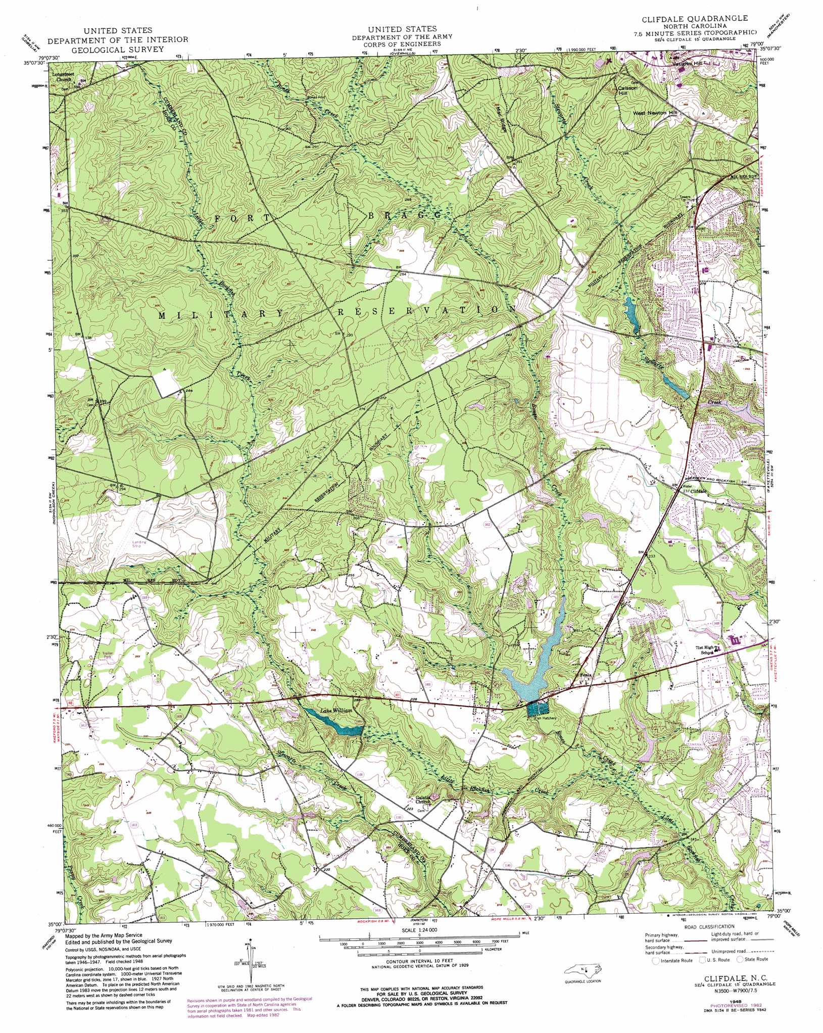
USGS Topo Quad 35079a1 - 1:24,000 scale
| Topo Map Name: | Clifdale |
| USGS Topo Quad ID: | 35079a1 |
| Print Size: | ca. 21 1/4" wide x 27" high |
| Southeast Coordinates: | 35° N latitude / 79° W longitude |
| Map Center Coordinates: | 35.0625° N latitude / 79.0625° W longitude |
| U.S. State: | NC |
| Filename: | o35079a1.jpg |
| Download Map JPG Image: | Clifdale topo map 1:24,000 scale |
| Map Type: | Topographic |
| Topo Series: | 7.5´ |
| Map Scale: | 1:24,000 |
| Source of Map Images: | United States Geological Survey (USGS) |
| Alternate Map Versions: |
Clifdale NC 1948, updated 1983 Download PDF Buy paper map Clifdale NC 1950 Download PDF Buy paper map Clifdale NC 1950, updated 1973 Download PDF Buy paper map Clifdale NC 1976, updated 1978 Download PDF Buy paper map Clifdale NC 2013 Download PDF Buy paper map Clifdale NC 2016 Download PDF Buy paper map |
1:24,000 Topo Quads surrounding Clifdale
Vass |
Murchisontown |
Olivia |
Anderson Creek |
Bunnlevel |
Niagara |
Lobelia |
Overhills |
Manchester |
Slocomb |
Mccain |
Nicholson Creek |
Clifdale |
Fayetteville |
Vander |
Wagram |
Raeford |
Parkton |
Hope Mills |
Cedar Creek |
Wakulla |
Red Springs |
Rennert |
Saint Pauls |
Duart |
> Back to 35079a1 at 1:100,000 scale
> Back to 35078a1 at 1:250,000 scale
> Back to U.S. Topo Maps home
Clifdale topo map: Gazetteer
Clifdale: Airports
Saint James Inn Airport elevation 81m 265′Clifdale: Dams
J C Keith Dam elevation 48m 157′Lake Rim Dam elevation 47m 154′
Lake Williams Dam elevation 49m 160′
Loraine Lake Dam elevation 56m 183′
NC Noname Eighty-Two Dam elevation 60m 196′
W P Sanders Pond Dam elevation 63m 206′
Clifdale: Lakes
Lommond Lake elevation 53m 173′Clifdale: Plains
Atlantic Coastal Plain elevation 55m 180′Clifdale: Populated Places
Bluesprings Woods elevation 58m 190′Bones Ford elevation 73m 239′
Clifdale elevation 73m 239′
Emerald Gardens elevation 62m 203′
Fenix elevation 63m 206′
Glenbrook elevation 68m 223′
Hickory Grove elevation 65m 213′
Loch Lommond elevation 68m 223′
Clifdale: Reservoirs
Hutaff Lake elevation 60m 196′J C Keith Lake elevation 48m 157′
Lake Rim elevation 47m 154′
Lake William elevation 50m 164′
Lake Williams elevation 49m 160′
Loraine Lake elevation 56m 183′
W P Sanders Pond Dam elevation 63m 206′
Clifdale: Ridges
Mac Ridge elevation 105m 344′Clifdale: Streams
Bones Creek elevation 42m 137′Clifdale: Summits
Caisson Hill elevation 105m 344′Vaughn Hill elevation 124m 406′
West Newton Hill elevation 114m 374′
Clifdale digital topo map on disk
Buy this Clifdale topo map showing relief, roads, GPS coordinates and other geographical features, as a high-resolution digital map file on DVD:
South Carolina, Western North Carolina & Northeastern Georgia
Buy digital topo maps: South Carolina, Western North Carolina & Northeastern Georgia