Nicholson Creek Topo Map North Carolina
To zoom in, hover over the map of Nicholson Creek
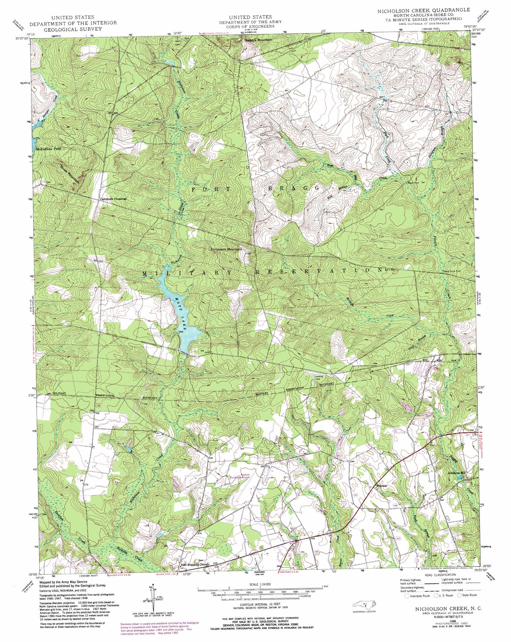
USGS Topo Quad 35079a2 - 1:24,000 scale
| Topo Map Name: | Nicholson Creek |
| USGS Topo Quad ID: | 35079a2 |
| Print Size: | ca. 21 1/4" wide x 27" high |
| Southeast Coordinates: | 35° N latitude / 79.125° W longitude |
| Map Center Coordinates: | 35.0625° N latitude / 79.1875° W longitude |
| U.S. State: | NC |
| Filename: | o35079a2.jpg |
| Download Map JPG Image: | Nicholson Creek topo map 1:24,000 scale |
| Map Type: | Topographic |
| Topo Series: | 7.5´ |
| Map Scale: | 1:24,000 |
| Source of Map Images: | United States Geological Survey (USGS) |
| Alternate Map Versions: |
Nicholson Creek NC 1948, updated 1974 Download PDF Buy paper map Nicholson Creek NC 1948, updated 1983 Download PDF Buy paper map Nicholson Creek NC 1948, updated 1983 Download PDF Buy paper map Nicholson Creek NC 1948, updated 1998 Download PDF Buy paper map Nicholson Creek NC 1950 Download PDF Buy paper map Nicholson Creek NC 1976, updated 1978 Download PDF Buy paper map Nicholson Creek NC 2013 Download PDF Buy paper map Nicholson Creek NC 2016 Download PDF Buy paper map |
1:24,000 Topo Quads surrounding Nicholson Creek
Carthage |
Vass |
Murchisontown |
Olivia |
Anderson Creek |
Southern Pines |
Niagara |
Lobelia |
Overhills |
Manchester |
Pinebluff |
Mccain |
Nicholson Creek |
Clifdale |
Fayetteville |
Silver Hill |
Wagram |
Raeford |
Parkton |
Hope Mills |
Laurinburg |
Wakulla |
Red Springs |
Rennert |
Saint Pauls |
> Back to 35079a1 at 1:100,000 scale
> Back to 35078a1 at 1:250,000 scale
> Back to U.S. Topo Maps home
Nicholson Creek topo map: Gazetteer
Nicholson Creek: Airports
Raeford Municipal Airport elevation 89m 291′Nicholson Creek: Crossings
Black Ford elevation 70m 229′Puppy Creek Ford elevation 64m 209′
Nicholson Creek: Dams
NC Noname Thirty-Four Dam elevation 72m 236′Nicholson Creek: Populated Places
Campbells Crossroad elevation 125m 410′Johnsons Mill elevation 53m 173′
Nicholson Creek: Reservoirs
Mott Lake elevation 73m 239′Nicholson Creek: Streams
Black Creek elevation 67m 219′Bull Branch elevation 73m 239′
McDuffie Creek elevation 60m 196′
Nicholson Creek elevation 55m 180′
Patterson Branch elevation 67m 219′
Rays Creek elevation 69m 226′
Trap Branch elevation 62m 203′
Nicholson Creek: Summits
Blues Mountain elevation 153m 501′Finlayson Mountain elevation 149m 488′
Gaddys Mountain elevation 160m 524′
Nicholson Creek digital topo map on disk
Buy this Nicholson Creek topo map showing relief, roads, GPS coordinates and other geographical features, as a high-resolution digital map file on DVD:
South Carolina, Western North Carolina & Northeastern Georgia
Buy digital topo maps: South Carolina, Western North Carolina & Northeastern Georgia