West End Topo Map North Carolina
To zoom in, hover over the map of West End
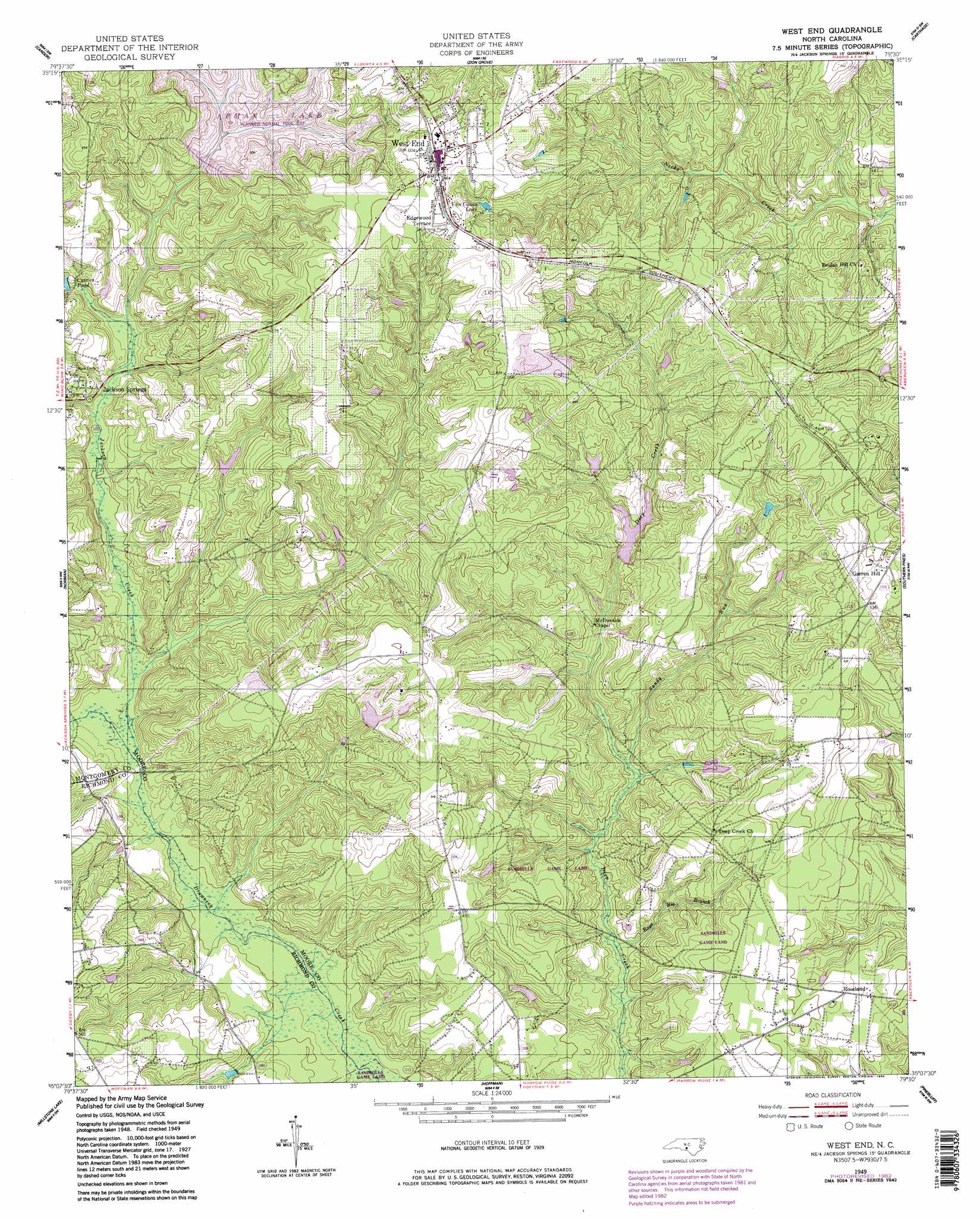
USGS Topo Quad 35079b5 - 1:24,000 scale
| Topo Map Name: | West End |
| USGS Topo Quad ID: | 35079b5 |
| Print Size: | ca. 21 1/4" wide x 27" high |
| Southeast Coordinates: | 35.125° N latitude / 79.5° W longitude |
| Map Center Coordinates: | 35.1875° N latitude / 79.5625° W longitude |
| U.S. State: | NC |
| Filename: | o35079b5.jpg |
| Download Map JPG Image: | West End topo map 1:24,000 scale |
| Map Type: | Topographic |
| Topo Series: | 7.5´ |
| Map Scale: | 1:24,000 |
| Source of Map Images: | United States Geological Survey (USGS) |
| Alternate Map Versions: |
West End NC 1949, updated 1953 Download PDF Buy paper map West End NC 1949, updated 1983 Download PDF Buy paper map West End NC 1949, updated 1983 Download PDF Buy paper map West End NC 1976, updated 1976 Download PDF Buy paper map West End NC 2010 Download PDF Buy paper map West End NC 2013 Download PDF Buy paper map West End NC 2016 Download PDF Buy paper map |
1:24,000 Topo Quads surrounding West End
Star |
Spies |
Robbins |
Putnam |
White Hill |
Biscoe |
Candor |
Zion Grove |
Carthage |
Vass |
Harrisville |
Norman |
West End |
Southern Pines |
Niagara |
Ellerbe |
Millstone Lake |
Hoffman |
Pinebluff |
Mccain |
Rockingham |
Hamlet |
Marston |
Silver Hill |
Wagram |
> Back to 35079a1 at 1:100,000 scale
> Back to 35078a1 at 1:250,000 scale
> Back to U.S. Topo Maps home
West End topo map: Gazetteer
West End: Airports
Foxfire Country Club Airpark elevation 168m 551′West End: Bridges
Pattersons Bridge elevation 110m 360′West End: Dams
Lake McKenzie Dam elevation 140m 459′Sandy Woods Lake Dam elevation 128m 419′
West End: Populated Places
Edgewood Terrace elevation 183m 600′Foxfire elevation 166m 544′
Garren Hill elevation 166m 544′
Roseland elevation 134m 439′
West End elevation 185m 606′
West End: Reservoirs
Curries Pond elevation 131m 429′Lake McKenzie elevation 140m 459′
Sandy Woods Lake elevation 128m 419′
Von Canon Lake elevation 162m 531′
West End: Streams
Jackson Creek elevation 110m 360′Rays Big Branch elevation 102m 334′
Sandy Run elevation 108m 354′
West End digital topo map on disk
Buy this West End topo map showing relief, roads, GPS coordinates and other geographical features, as a high-resolution digital map file on DVD:
South Carolina, Western North Carolina & Northeastern Georgia
Buy digital topo maps: South Carolina, Western North Carolina & Northeastern Georgia