Olivia Topo Map North Carolina
To zoom in, hover over the map of Olivia
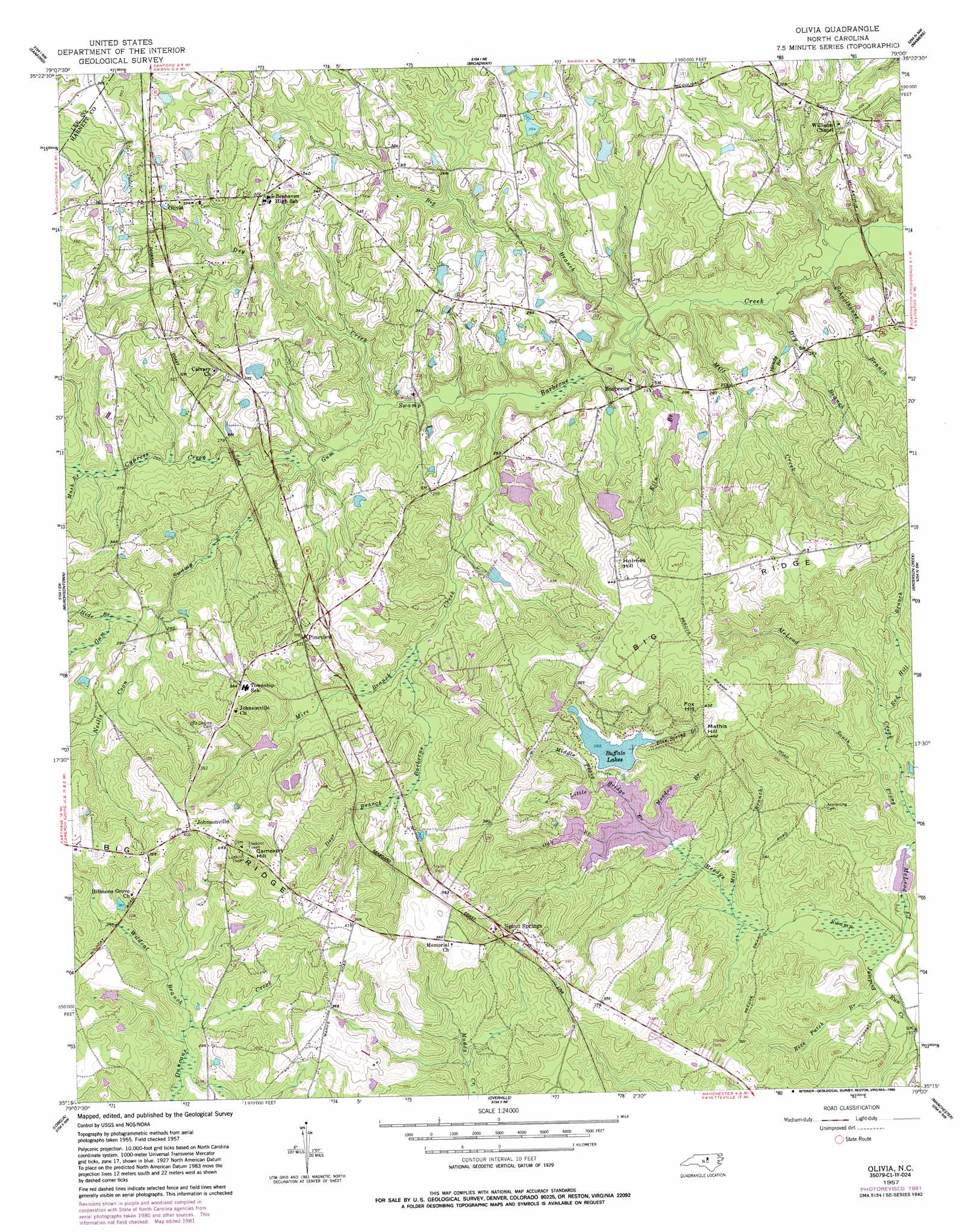
USGS Topo Quad 35079c1 - 1:24,000 scale
| Topo Map Name: | Olivia |
| USGS Topo Quad ID: | 35079c1 |
| Print Size: | ca. 21 1/4" wide x 27" high |
| Southeast Coordinates: | 35.25° N latitude / 79° W longitude |
| Map Center Coordinates: | 35.3125° N latitude / 79.0625° W longitude |
| U.S. State: | NC |
| Filename: | o35079c1.jpg |
| Download Map JPG Image: | Olivia topo map 1:24,000 scale |
| Map Type: | Topographic |
| Topo Series: | 7.5´ |
| Map Scale: | 1:24,000 |
| Source of Map Images: | United States Geological Survey (USGS) |
| Alternate Map Versions: |
Olivia NC 1957, updated 1986 Download PDF Buy paper map Olivia NC 2013 Download PDF Buy paper map Olivia NC 2016 Download PDF Buy paper map |
1:24,000 Topo Quads surrounding Olivia
Goldston |
Colon |
Moncure |
Cokesbury |
Fuquay-Varina |
White Hill |
Sanford |
Broadway |
Mamers |
Lillington |
Vass |
Murchisontown |
Olivia |
Anderson Creek |
Bunnlevel |
Niagara |
Lobelia |
Overhills |
Manchester |
Slocomb |
Mccain |
Nicholson Creek |
Clifdale |
Fayetteville |
Vander |
> Back to 35079a1 at 1:100,000 scale
> Back to 35078a1 at 1:250,000 scale
> Back to U.S. Topo Maps home
Olivia topo map: Gazetteer
Olivia: Airports
Craven Field elevation 96m 314′Olivia: Dams
Blanchards Pond Dam Number One elevation 89m 291′Blanchards Pond Dam Number Two elevation 84m 275′
Boyce Olive Dam elevation 95m 311′
Buffalo Lake Dam elevation 91m 298′
F S Blanchards Dam Number Three elevation 76m 249′
R E Roberts Dam elevation 82m 269′
Silver Run Lake Dam elevation 68m 223′
Williams Pond Dam elevation 60m 196′
Olivia: Populated Places
Barbecue elevation 76m 249′Johnsonville elevation 123m 403′
Olivia elevation 93m 305′
Pineview elevation 98m 321′
Spout Springs elevation 103m 337′
Olivia: Reservoirs
Blanchards Pond elevation 89m 291′Buffalo Lakes elevation 91m 298′
Silver Run Lake elevation 68m 223′
Williams Pond elevation 60m 196′
Olivia: Streams
Big Branch elevation 64m 209′Blue Spring Branch elevation 92m 301′
Cypress Creek elevation 72m 236′
Deer Branch elevation 84m 275′
Dry Branch elevation 61m 200′
Dry Creek elevation 69m 226′
Gum Swamp elevation 67m 219′
Handy Branch elevation 78m 255′
Hide Branch elevation 80m 262′
Kiln Branch elevation 65m 213′
Little Bridge Branch elevation 62m 203′
Mash Branch elevation 79m 259′
McLeod Creek elevation 60m 196′
Meadow Branch elevation 76m 249′
Middle Prong Little Bridge Branch elevation 78m 255′
Mill Branch elevation 66m 216′
Mill Creek elevation 63m 206′
Mire Branch elevation 75m 246′
Neills Coon Branch elevation 80m 262′
Oak Branch elevation 76m 249′
Red Hill Branch elevation 74m 242′
Schoolhouse Branch elevation 61m 200′
Wildcat Branch elevation 80m 262′
Olivia: Summits
Cameron Hill elevation 148m 485′Fox Hill elevation 125m 410′
Holmes Hill elevation 141m 462′
Mathis Hill elevation 121m 396′
Olivia: Swamps
Reedys Swamp elevation 64m 209′Olivia digital topo map on disk
Buy this Olivia topo map showing relief, roads, GPS coordinates and other geographical features, as a high-resolution digital map file on DVD:
South Carolina, Western North Carolina & Northeastern Georgia
Buy digital topo maps: South Carolina, Western North Carolina & Northeastern Georgia