Troy Topo Map North Carolina
To zoom in, hover over the map of Troy
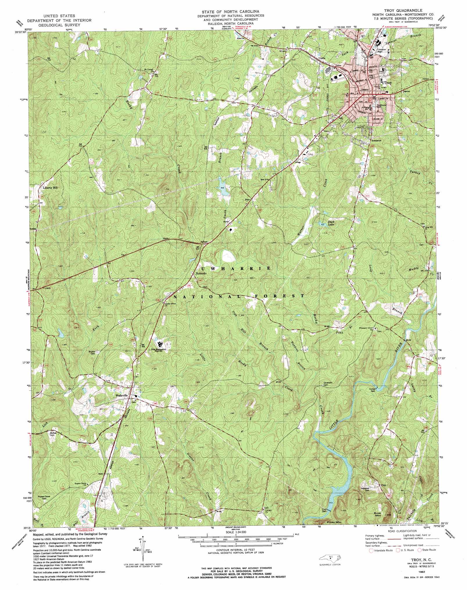
USGS Topo Quad 35079c8 - 1:24,000 scale
| Topo Map Name: | Troy |
| USGS Topo Quad ID: | 35079c8 |
| Print Size: | ca. 21 1/4" wide x 27" high |
| Southeast Coordinates: | 35.25° N latitude / 79.875° W longitude |
| Map Center Coordinates: | 35.3125° N latitude / 79.9375° W longitude |
| U.S. State: | NC |
| Filename: | o35079c8.jpg |
| Download Map JPG Image: | Troy topo map 1:24,000 scale |
| Map Type: | Topographic |
| Topo Series: | 7.5´ |
| Map Scale: | 1:24,000 |
| Source of Map Images: | United States Geological Survey (USGS) |
| Alternate Map Versions: |
Troy NC 1982, updated 1983 Download PDF Buy paper map Troy NC 1994, updated 1996 Download PDF Buy paper map Troy NC 2011 Download PDF Buy paper map Troy NC 2013 Download PDF Buy paper map Troy NC 2016 Download PDF Buy paper map |
| FStopo: | US Forest Service topo Troy is available: Download FStopo PDF Download FStopo TIF |
1:24,000 Topo Quads surrounding Troy
High Rock |
Handy |
Eleazer |
Seagrove |
Erect |
New London |
Badin |
Lovejoy |
Star |
Spies |
Albemarle |
Morrow Mountain |
Troy |
Biscoe |
Candor |
Aquadale |
Mount Gilead West |
Mount Gilead East |
Harrisville |
Norman |
Polkton |
Ansonville |
Mangum |
Ellerbe |
Millstone Lake |
> Back to 35079a1 at 1:100,000 scale
> Back to 35078a1 at 1:250,000 scale
> Back to U.S. Topo Maps home
Troy topo map: Gazetteer
Troy: Airports
Birds Nest Airport elevation 199m 652′Troy: Dams
Alexander Pond Dam elevation 167m 547′Bruton Millpond Dam elevation 110m 360′
Eury Dam elevation 82m 269′
Hurley Dam elevation 100m 328′
Troy: Populated Places
Chip elevation 149m 488′Liberty Hill elevation 213m 698′
Roberdo elevation 162m 531′
Troy elevation 200m 656′
Wadeville elevation 161m 528′
Troy: Post Offices
Troy Post Office elevation 188m 616′Troy: Reservoirs
Alexander Pond elevation 167m 547′Bruton Mill Pond elevation 110m 360′
Duck Lake elevation 144m 472′
Eure Lake elevation 86m 282′
Troy: Streams
Cedar Branch elevation 95m 311′Hawkins Branch elevation 102m 334′
Hill Branch elevation 106m 347′
Iron Hill Branch elevation 106m 347′
Lick Branch elevation 93m 305′
Little Rocky Creek elevation 105m 344′
Long Branch elevation 106m 347′
Lucky Branch elevation 111m 364′
Rocky Creek elevation 94m 308′
Smith Branch elevation 133m 436′
Toms Branch elevation 121m 396′
Warner Creek elevation 125m 410′
Troy: Summits
Buck Mountain elevation 177m 580′Piney Mountain elevation 168m 551′
Troy digital topo map on disk
Buy this Troy topo map showing relief, roads, GPS coordinates and other geographical features, as a high-resolution digital map file on DVD:
South Carolina, Western North Carolina & Northeastern Georgia
Buy digital topo maps: South Carolina, Western North Carolina & Northeastern Georgia