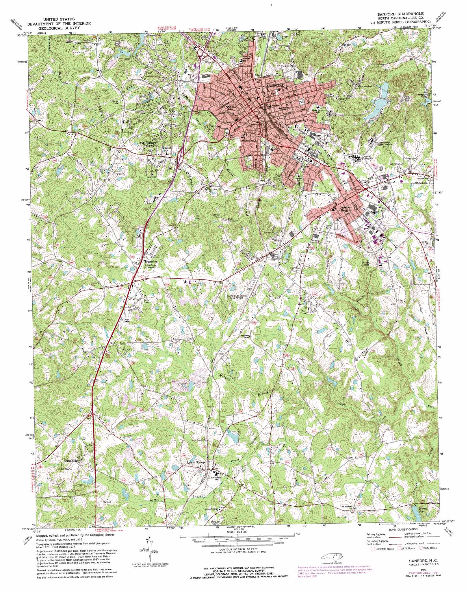
Sanford Topo Map North Carolina
To zoom in, hover over the map of Sanford
USGS Topo Quad 35079d2 - 1:24,000 scale
| Topo Map Name: | Sanford |
| USGS Topo Quad ID: | 35079d2 |
| Print Size: | ca. 21 1/4" wide x 27" high |
| Southeast Coordinates: | 35.375° N latitude / 79.125° W longitude |
| Map Center Coordinates: | 35.4375° N latitude / 79.1875° W longitude |
| U.S. State: | NC |
| Filename: | o35079d2.jpg |
| Download Map JPG Image: | Sanford topo map 1:24,000 scale |
| Map Type: | Topographic |
| Topo Series: | 7.5´ |
| Map Scale: | 1:24,000 |
| Source of Map Images: | United States Geological Survey (USGS) |
| Alternate Map Versions: |
Sanford NC 1974, updated 1977 Download PDF Buy paper map Sanford NC 1974, updated 1982 Download PDF Buy paper map Sanford NC 1980, updated 1983 Download PDF Buy paper map Sanford NC 2010 Download PDF Buy paper map Sanford NC 2013 Download PDF Buy paper map Sanford NC 2016 Download PDF Buy paper map |
1:24,000 Topo Quads surrounding Sanford
Siler City |
Siler City Ne |
Pittsboro |
Merry Oaks |
New Hill |
Bear Creek |
Goldston |
Colon |
Moncure |
Cokesbury |
Putnam |
White Hill |
Sanford |
Broadway |
Mamers |
Carthage |
Vass |
Murchisontown |
Olivia |
Anderson Creek |
Southern Pines |
Niagara |
Lobelia |
Overhills |
Manchester |
> Back to 35079a1 at 1:100,000 scale
> Back to 35078a1 at 1:250,000 scale
> Back to U.S. Topo Maps home
Sanford topo map: Gazetteer
Sanford: Airports
Raleigh Executive Jetport @ Sanford-Lee County elevation 134m 439′Sanford: Dams
Holiday Lake Upper Dam elevation 96m 314′Morris Pond Dam elevation 88m 288′
Oldham Lake Lower Dam elevation 87m 285′
Oldham Lake Upper Dam elevation 93m 305′
Willette Lake Dam elevation 121m 396′
Winstead Pond Dam elevation 112m 367′
Sanford: Lakes
Oldhams Lake elevation 96m 314′Sanford: Populated Places
Berkley Place elevation 98m 321′Brentwood elevation 106m 347′
Brookhaven elevation 132m 433′
Brookwood elevation 95m 311′
Carbonton Heights elevation 105m 344′
Clearwater Forest elevation 108m 354′
Colonial Acres elevation 107m 351′
Cool Springs elevation 117m 383′
Country Lane Estates elevation 147m 482′
Courtland Acres elevation 124m 406′
Hanover Circle elevation 106m 347′
Jonesboro Heights elevation 133m 436′
Kendall Acres elevation 122m 400′
Lemon Springs elevation 119m 390′
Longview Acres elevation 111m 364′
McCracken Heights elevation 102m 334′
Meadow Park elevation 136m 446′
Owls Nest elevation 131m 429′
Parkwood Estates elevation 124m 406′
Planters Ridge elevation 105m 344′
Quail Ridge elevation 135m 442′
Royal Oaks elevation 93m 305′
Saint Andrews elevation 123m 403′
Sanford elevation 109m 357′
San-Lee Park elevation 103m 337′
Sunset Terrace elevation 114m 374′
Trails End elevation 128m 419′
Tramway elevation 149m 488′
West Lake Valley elevation 108m 354′
Westcroft elevation 104m 341′
Western Hills elevation 122m 400′
Woodbridge elevation 104m 341′
Sanford: Reservoirs
Holiday Lake Upper elevation 96m 314′Morris Pond elevation 88m 288′
Oldham Lake One elevation 93m 305′
Oldham Lake Two elevation 87m 285′
Willett Lake elevation 121m 396′
Winstead Pond elevation 112m 367′
Sanford: Streams
Gasters Creek elevation 81m 265′Little Juniper Creek elevation 104m 341′
Mulatto Branch elevation 101m 331′
Persimmon Creek elevation 86m 282′
Skunk Creek elevation 87m 285′
Sanford digital topo map on disk
Buy this Sanford topo map showing relief, roads, GPS coordinates and other geographical features, as a high-resolution digital map file on DVD:
South Carolina, Western North Carolina & Northeastern Georgia
Buy digital topo maps: South Carolina, Western North Carolina & Northeastern Georgia