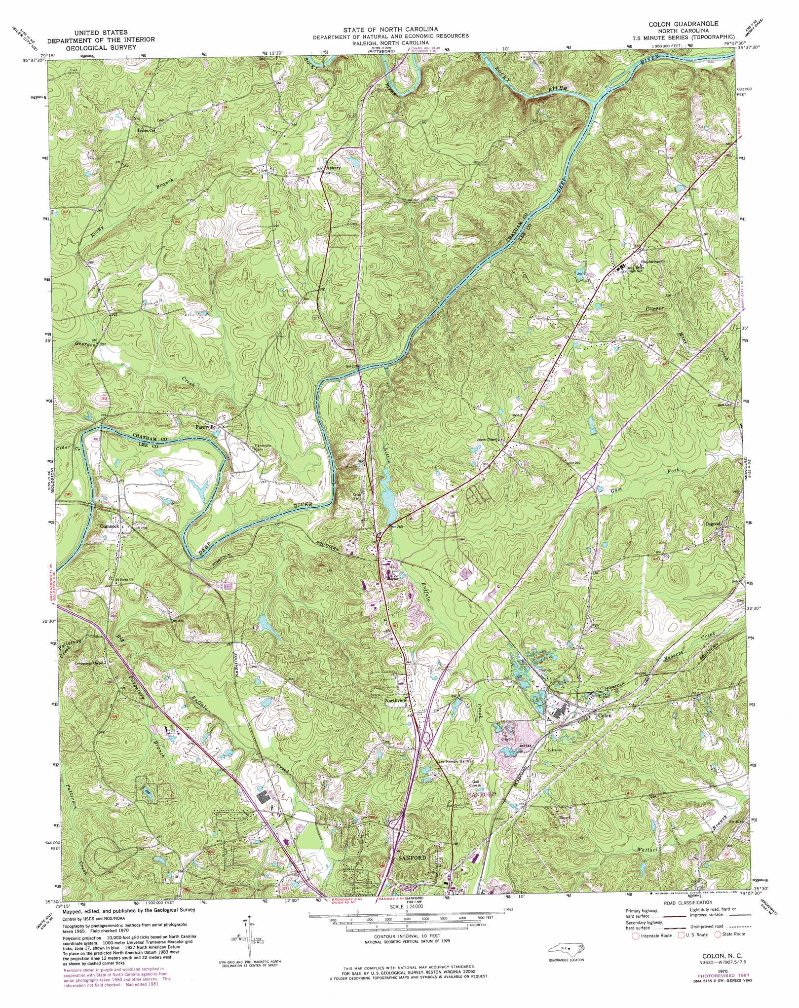
Colon Topo Map North Carolina
To zoom in, hover over the map of Colon
USGS Topo Quad 35079e2 - 1:24,000 scale
| Topo Map Name: | Colon |
| USGS Topo Quad ID: | 35079e2 |
| Print Size: | ca. 21 1/4" wide x 27" high |
| Southeast Coordinates: | 35.5° N latitude / 79.125° W longitude |
| Map Center Coordinates: | 35.5625° N latitude / 79.1875° W longitude |
| U.S. State: | NC |
| Filename: | o35079e2.jpg |
| Download Map JPG Image: | Colon topo map 1:24,000 scale |
| Map Type: | Topographic |
| Topo Series: | 7.5´ |
| Map Scale: | 1:24,000 |
| Source of Map Images: | United States Geological Survey (USGS) |
| Alternate Map Versions: |
Colon NC 1970, updated 1973 Download PDF Buy paper map Colon NC 1970, updated 1982 Download PDF Buy paper map Colon NC 2010 Download PDF Buy paper map Colon NC 2013 Download PDF Buy paper map Colon NC 2016 Download PDF Buy paper map |
1:24,000 Topo Quads surrounding Colon
Crutchfield Crossroads |
Silk Hope |
Bynum |
Farrington |
Green Level |
Siler City |
Siler City Ne |
Pittsboro |
Merry Oaks |
New Hill |
Bear Creek |
Goldston |
Colon |
Moncure |
Cokesbury |
Putnam |
White Hill |
Sanford |
Broadway |
Mamers |
Carthage |
Vass |
Murchisontown |
Olivia |
Anderson Creek |
> Back to 35079e1 at 1:100,000 scale
> Back to 35078a1 at 1:250,000 scale
> Back to U.S. Topo Maps home
Colon topo map: Gazetteer
Colon: Dams
Bright Pond Dam elevation 92m 301′Holiday Lake Dam Lower elevation 94m 308′
Sky View Lake Dam elevation 78m 255′
Colon: Populated Places
Asbury elevation 117m 383′Colon elevation 97m 318′
Cool Springs Estates elevation 109m 357′
Cumnock elevation 83m 272′
Farmville elevation 86m 282′
Forest Hills elevation 90m 295′
Glenwood Village elevation 95m 311′
Green Valley Estates elevation 90m 295′
Hawkins Run elevation 107m 351′
Hidden Valley elevation 98m 321′
Highland Acres elevation 92m 301′
Holly Hills elevation 92m 301′
Nob Hill elevation 83m 272′
Northview elevation 95m 311′
Osgood elevation 95m 311′
Stoneybrook elevation 91m 298′
Wildwood elevation 93m 305′
Colon: Reservoirs
Bright Pond elevation 92m 301′Holiday Lake elevation 94m 308′
Sky View Lake elevation 78m 255′
Colon: Streams
Big Buffalo Creek elevation 65m 213′Cedar Creek elevation 66m 216′
Georges Creek elevation 63m 206′
Little Buffalo Creek elevation 63m 206′
Purgatory Branch elevation 75m 246′
Rocky Branch elevation 60m 196′
Rocky Branch elevation 69m 226′
Rocky River elevation 62m 203′
Colon digital topo map on disk
Buy this Colon topo map showing relief, roads, GPS coordinates and other geographical features, as a high-resolution digital map file on DVD:
South Carolina, Western North Carolina & Northeastern Georgia
Buy digital topo maps: South Carolina, Western North Carolina & Northeastern Georgia