Seagrove Topo Map North Carolina
To zoom in, hover over the map of Seagrove
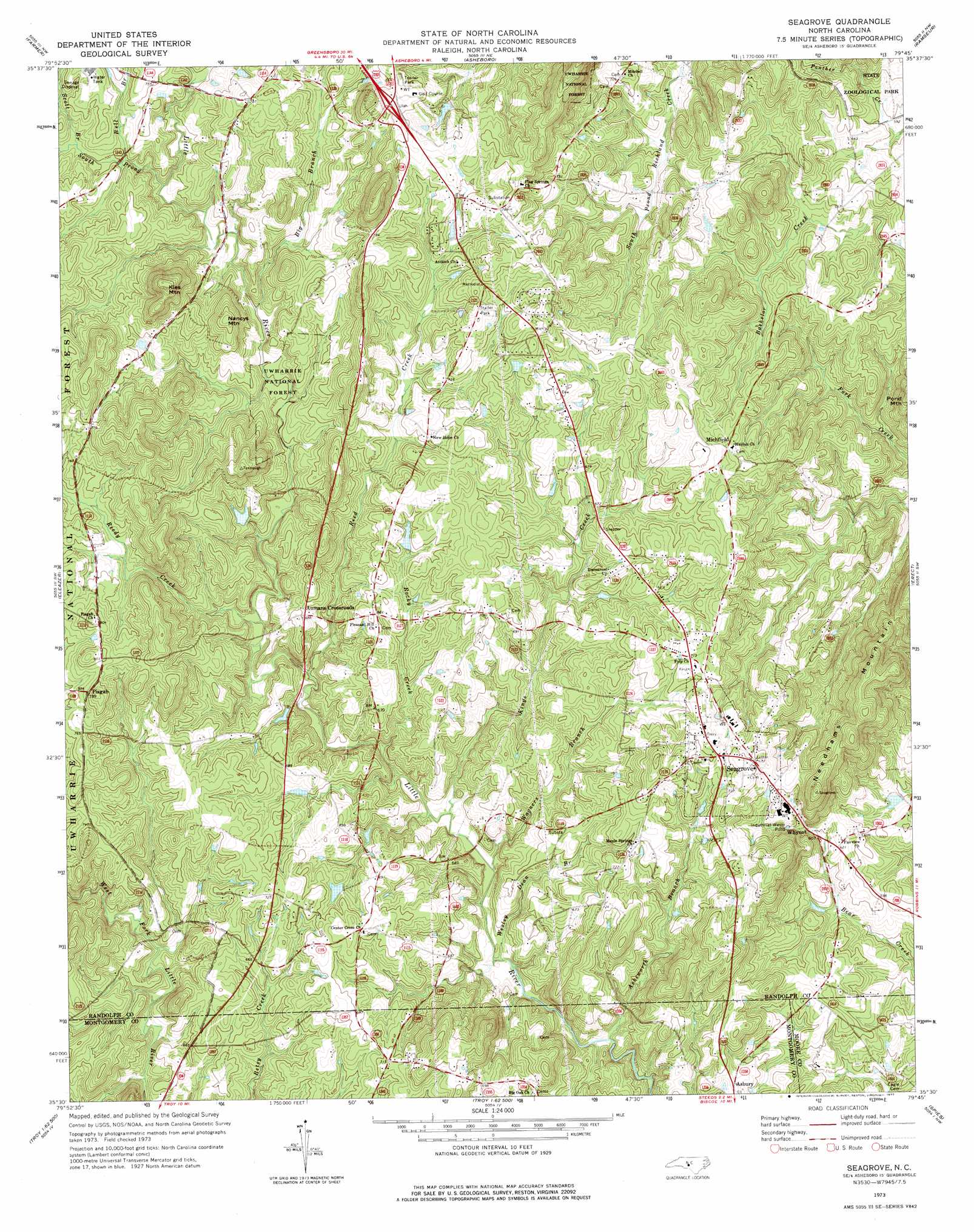
USGS Topo Quad 35079e7 - 1:24,000 scale
| Topo Map Name: | Seagrove |
| USGS Topo Quad ID: | 35079e7 |
| Print Size: | ca. 21 1/4" wide x 27" high |
| Southeast Coordinates: | 35.5° N latitude / 79.75° W longitude |
| Map Center Coordinates: | 35.5625° N latitude / 79.8125° W longitude |
| U.S. State: | NC |
| Filename: | o35079e7.jpg |
| Download Map JPG Image: | Seagrove topo map 1:24,000 scale |
| Map Type: | Topographic |
| Topo Series: | 7.5´ |
| Map Scale: | 1:24,000 |
| Source of Map Images: | United States Geological Survey (USGS) |
| Alternate Map Versions: |
Seagrove NC 1973, updated 1977 Download PDF Buy paper map Seagrove NC 1994, updated 1996 Download PDF Buy paper map Seagrove NC 2011 Download PDF Buy paper map Seagrove NC 2013 Download PDF Buy paper map Seagrove NC 2016 Download PDF Buy paper map |
| FStopo: | US Forest Service topo Seagrove is available: Download FStopo PDF Download FStopo TIF |
1:24,000 Topo Quads surrounding Seagrove
Fair Grove |
Glenola |
Randleman |
Grays Chapel |
Liberty |
Denton |
Farmer |
Asheboro |
Ramseur |
Coleridge |
Handy |
Eleazer |
Seagrove |
Erect |
Bennett |
Badin |
Lovejoy |
Star |
Spies |
Robbins |
Morrow Mountain |
Troy |
Biscoe |
Candor |
Zion Grove |
> Back to 35079e1 at 1:100,000 scale
> Back to 35078a1 at 1:250,000 scale
> Back to U.S. Topo Maps home
Seagrove topo map: Gazetteer
Seagrove: Dams
Auman Lake Dam elevation 207m 679′Blacks Lake Dam elevation 210m 688′
Hurley Lake Dam elevation 248m 813′
Slacks Lake Dam elevation 170m 557′
Wimbish Lake Dam elevation 204m 669′
Seagrove: Populated Places
Aumans Crossroads elevation 210m 688′Black Ankle elevation 209m 685′
Michfield elevation 224m 734′
Pisgah elevation 240m 787′
Seagrove elevation 228m 748′
Seagrove: Reservoirs
Auman Lake elevation 207m 679′Blacks Lake elevation 210m 688′
Hurley Lake elevation 248m 813′
Slacks Lake elevation 170m 557′
Wimbish Lake elevation 204m 669′
Seagrove: Streams
Asheworth Branch elevation 168m 551′Bell Branch elevation 211m 692′
Big Branch elevation 197m 646′
Kings Creek elevation 176m 577′
Reed Creek elevation 180m 590′
Reedy Creek elevation 187m 613′
Rocky Creek elevation 178m 583′
Scott Branch elevation 214m 702′
South Prong Little River elevation 205m 672′
Wagners Branch elevation 173m 567′
Wesley Dean Branch elevation 173m 567′
Seagrove: Summits
Kies Mountain elevation 279m 915′Nancys Mountain elevation 251m 823′
Needhams Mountain elevation 253m 830′
Seagrove digital topo map on disk
Buy this Seagrove topo map showing relief, roads, GPS coordinates and other geographical features, as a high-resolution digital map file on DVD:
South Carolina, Western North Carolina & Northeastern Georgia
Buy digital topo maps: South Carolina, Western North Carolina & Northeastern Georgia