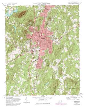
Asheboro Topo Map North Carolina
To zoom in, hover over the map of Asheboro
USGS Topo Quad 35079f7 - 1:24,000 scale
| Topo Map Name: | Asheboro |
| USGS Topo Quad ID: | 35079f7 |
| Print Size: | ca. 21 1/4" wide x 27" high |
| Southeast Coordinates: | 35.625° N latitude / 79.75° W longitude |
| Map Center Coordinates: | 35.6875° N latitude / 79.8125° W longitude |
| U.S. State: | NC |
| Filename: | o35079f7.jpg |
| Download Map JPG Image: | Asheboro topo map 1:24,000 scale |
| Map Type: | Topographic |
| Topo Series: | 7.5´ |
| Map Scale: | 1:24,000 |
| Source of Map Images: | United States Geological Survey (USGS) |
| Alternate Map Versions: |
Asheboro NC 1970, updated 1974 Download PDF Buy paper map Asheboro NC 1970, updated 1982 Download PDF Buy paper map Asheboro NC 1980, updated 1983 Download PDF Buy paper map Asheboro NC 1994, updated 1996 Download PDF Buy paper map Asheboro NC 2011 Download PDF Buy paper map Asheboro NC 2013 Download PDF Buy paper map Asheboro NC 2016 Download PDF Buy paper map |
| FStopo: | US Forest Service topo Asheboro is available: Download FStopo PDF Download FStopo TIF |
1:24,000 Topo Quads surrounding Asheboro
> Back to 35079e1 at 1:100,000 scale
> Back to 35078a1 at 1:250,000 scale
> Back to U.S. Topo Maps home
Asheboro topo map: Gazetteer
Asheboro: Airports
Hinshaw Airport elevation 225m 738′Asheboro: Dams
Cedarwood Dam elevation 176m 577′Farlow Lake Dam elevation 204m 669′
John Bunch Lake Dam elevation 167m 547′
Shaw-Hudson Lake Dam elevation 174m 570′
W A McCrary Lake Dam elevation 162m 531′
Asheboro: Parks
North Carolina Zoological Park elevation 246m 807′Asheboro: Populated Places
Asheboro elevation 256m 839′Briarcliff elevation 227m 744′
Cedar Creek elevation 202m 662′
Country Place elevation 214m 702′
Hamlet Lakes elevation 230m 754′
Hedrick Mountain elevation 273m 895′
Laurel Wood Hills elevation 200m 656′
North Asheboro elevation 239m 784′
North Shore elevation 225m 738′
Piney Mountain Estates elevation 239m 784′
Redding Hills elevation 275m 902′
Ulah elevation 255m 836′
Westridge elevation 244m 800′
Winningham Farm elevation 230m 754′
Asheboro: Post Offices
Asheboro Post Office elevation 252m 826′Asheboro: Reservoirs
Cedarwood Lake elevation 176m 577′Farlows Lake elevation 204m 669′
John Bunch Lake elevation 167m 547′
Shaw-Hudson Lake elevation 174m 570′
W A McCrary Lake elevation 162m 531′
Asheboro: Ridges
Schoolhouse Ridge elevation 228m 748′Asheboro: Streams
Greenes Branch elevation 158m 518′Long Branch elevation 153m 501′
North Prong Richland Creek elevation 176m 577′
South Prong Richland Creek elevation 176m 577′
Tantraugh Branch elevation 174m 570′
Vestal Creek elevation 174m 570′
Asheboro: Summits
Back Creek Mountain elevation 333m 1092′Cox Mountain elevation 262m 859′
Daves Mountain elevation 335m 1099′
Harveys Mountain elevation 288m 944′
Hedrick Mountain elevation 295m 967′
Horse Mountain elevation 292m 958′
Middle Mountain elevation 252m 826′
Oakie Mountain elevation 313m 1026′
Purgatory Mountain elevation 285m 935′
Stack Rock Mountain elevation 271m 889′
Asheboro digital topo map on disk
Buy this Asheboro topo map showing relief, roads, GPS coordinates and other geographical features, as a high-resolution digital map file on DVD:
South Carolina, Western North Carolina & Northeastern Georgia
Buy digital topo maps: South Carolina, Western North Carolina & Northeastern Georgia


