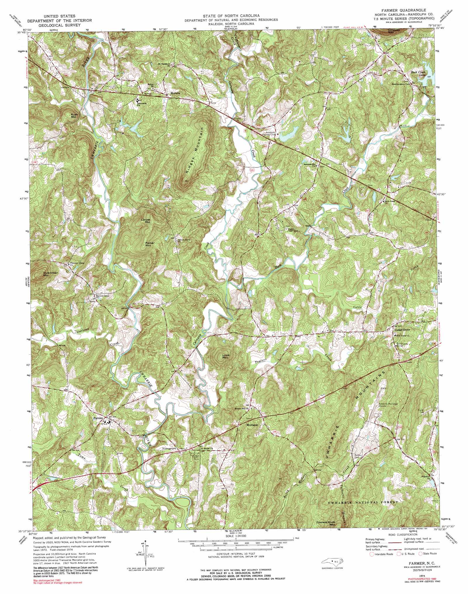
Farmer Topo Map North Carolina
To zoom in, hover over the map of Farmer
USGS Topo Quad 35079f8 - 1:24,000 scale
| Topo Map Name: | Farmer |
| USGS Topo Quad ID: | 35079f8 |
| Print Size: | ca. 21 1/4" wide x 27" high |
| Southeast Coordinates: | 35.625° N latitude / 79.875° W longitude |
| Map Center Coordinates: | 35.6875° N latitude / 79.9375° W longitude |
| U.S. State: | NC |
| Filename: | o35079f8.jpg |
| Download Map JPG Image: | Farmer topo map 1:24,000 scale |
| Map Type: | Topographic |
| Topo Series: | 7.5´ |
| Map Scale: | 1:24,000 |
| Source of Map Images: | United States Geological Survey (USGS) |
| Alternate Map Versions: |
Farmer NC 1974, updated 1977 Download PDF Buy paper map Farmer NC 1974, updated 1991 Download PDF Buy paper map Farmer NC 1994, updated 1996 Download PDF Buy paper map Farmer NC 2011 Download PDF Buy paper map Farmer NC 2013 Download PDF Buy paper map Farmer NC 2016 Download PDF Buy paper map |
| FStopo: | US Forest Service topo Farmer is available: Download FStopo PDF Download FStopo TIF |
1:24,000 Topo Quads surrounding Farmer
Midway |
High Point West |
High Point East |
Pleasant Garden |
Climax |
Lexington East |
Fair Grove |
Glenola |
Randleman |
Grays Chapel |
Denton Nw |
Denton |
Farmer |
Asheboro |
Ramseur |
High Rock |
Handy |
Eleazer |
Seagrove |
Erect |
New London |
Badin |
Lovejoy |
Star |
Spies |
> Back to 35079e1 at 1:100,000 scale
> Back to 35078a1 at 1:250,000 scale
> Back to U.S. Topo Maps home
Farmer topo map: Gazetteer
Farmer: Airports
Asheboro Municipal Airport elevation 209m 685′Farmer: Dams
Asheboro Country Club Lake Dam elevation 157m 515′Clyde Lucas Lake Dam elevation 144m 472′
Lake Wood Dam elevation 156m 511′
Woods Lake Dam Lower elevation 142m 465′
Woods Lake Dam Upper elevation 148m 485′
Farmer: Populated Places
Cedar Grove elevation 182m 597′Farmer elevation 163m 534′
Mechanic elevation 176m 577′
Motleta elevation 177m 580′
Farmer: Reservoirs
Asheboro County Club Lake elevation 157m 515′Back Creek Lake elevation 158m 518′
Lake Wood elevation 156m 511′
W Clyde Lucas Lake elevation 144m 472′
Woods Lake Number One elevation 142m 465′
Woods Lake Number Two elevation 148m 485′
Farmer: Streams
Back Creek elevation 126m 413′Cable Creek elevation 129m 423′
Caraway Creek elevation 119m 390′
Cedar Fork Creek elevation 143m 469′
Jackson Creek elevation 121m 396′
Little Caraway Creek elevation 136m 446′
Talbotts Branch elevation 175m 574′
Taylors Creek elevation 124m 406′
Farmer: Summits
Dutchman Mountain elevation 265m 869′Locust Mountain elevation 237m 777′
Lowe Mountain elevation 210m 688′
Parker Mountain elevation 221m 725′
Ridges Mountain elevation 253m 830′
Rush Mountain elevation 202m 662′
Farmer digital topo map on disk
Buy this Farmer topo map showing relief, roads, GPS coordinates and other geographical features, as a high-resolution digital map file on DVD:
South Carolina, Western North Carolina & Northeastern Georgia
Buy digital topo maps: South Carolina, Western North Carolina & Northeastern Georgia