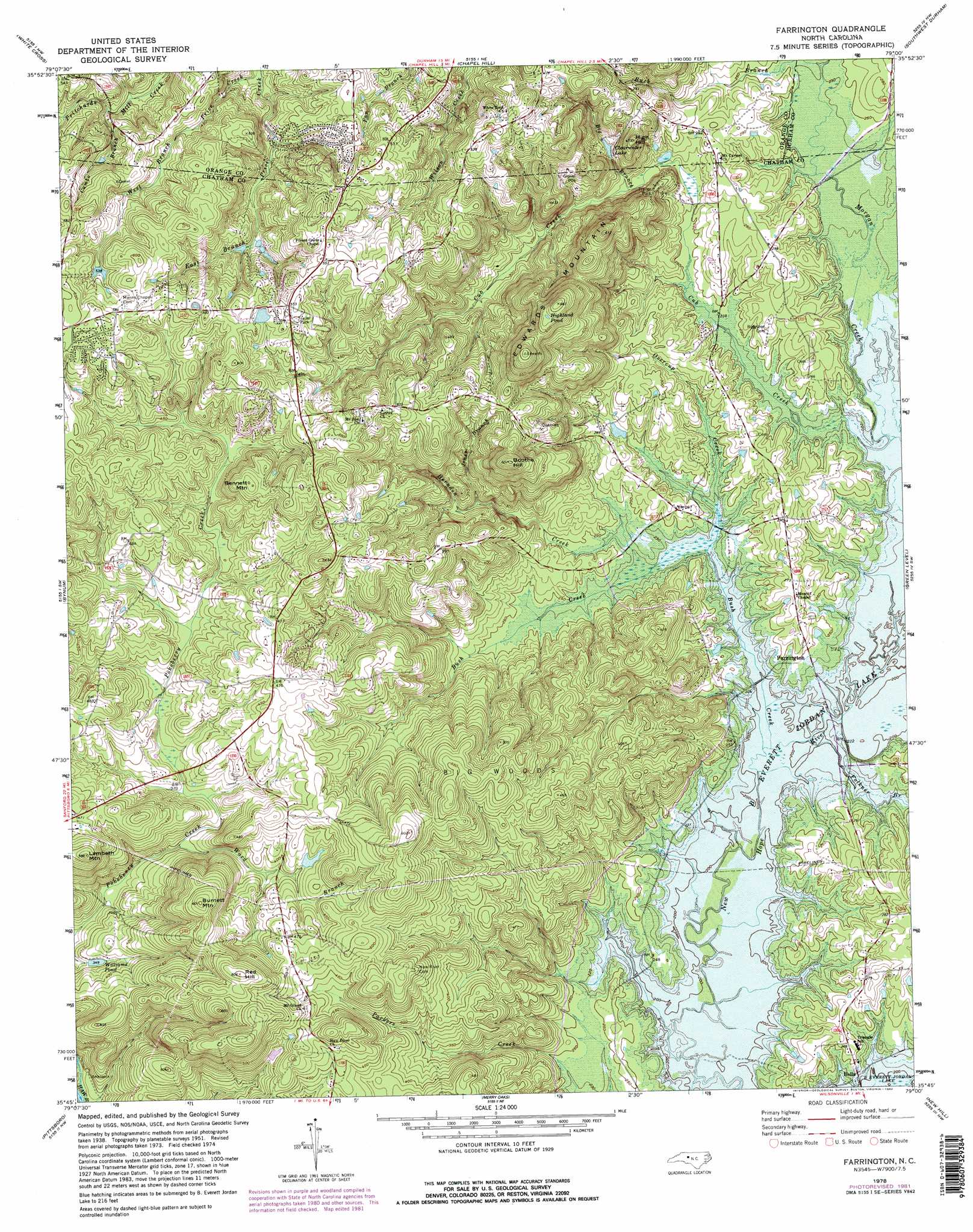
Farrington Topo Map North Carolina
To zoom in, hover over the map of Farrington
USGS Topo Quad 35079g1 - 1:24,000 scale
| Topo Map Name: | Farrington |
| USGS Topo Quad ID: | 35079g1 |
| Print Size: | ca. 21 1/4" wide x 27" high |
| Southeast Coordinates: | 35.75° N latitude / 79° W longitude |
| Map Center Coordinates: | 35.8125° N latitude / 79.0625° W longitude |
| U.S. State: | NC |
| Filename: | o35079g1.jpg |
| Download Map JPG Image: | Farrington topo map 1:24,000 scale |
| Map Type: | Topographic |
| Topo Series: | 7.5´ |
| Map Scale: | 1:24,000 |
| Source of Map Images: | United States Geological Survey (USGS) |
| Alternate Map Versions: |
Farrington NC 1951, updated 1952 Download PDF Buy paper map Farrington NC 1951, updated 1967 Download PDF Buy paper map Farrington NC 1951, updated 1976 Download PDF Buy paper map Farrington NC 1978, updated 1978 Download PDF Buy paper map Farrington NC 1978, updated 1982 Download PDF Buy paper map Farrington NC 1993, updated 1999 Download PDF Buy paper map Farrington NC 2010 Download PDF Buy paper map Farrington NC 2013 Download PDF Buy paper map Farrington NC 2016 Download PDF Buy paper map |
1:24,000 Topo Quads surrounding Farrington
Mebane |
Efland |
Hillsborough |
Northwest Durham |
Northeast Durham |
Saxapahaw |
White Cross |
Chapel Hill |
Southwest Durham |
Southeast Durham |
Silk Hope |
Bynum |
Farrington |
Green Level |
Cary |
Siler City Ne |
Pittsboro |
Merry Oaks |
New Hill |
Apex |
Goldston |
Colon |
Moncure |
Cokesbury |
Fuquay-Varina |
> Back to 35079e1 at 1:100,000 scale
> Back to 35078a1 at 1:250,000 scale
> Back to U.S. Topo Maps home
Farrington topo map: Gazetteer
Farrington: Airports
American Telephone and Telegraph Company Airport elevation 183m 600′Farrington: Dams
Cedar Village Lake Dam elevation 164m 538′Clearwater Lake Dam elevation 95m 311′
King Pond Dam elevation 125m 410′
Farrington: Lakes
Highland Pond elevation 189m 620′Farrington: Parks
Jordan Lake State Recreation Area elevation 72m 236′Farrington: Populated Places
Bells elevation 70m 229′Farrington elevation 72m 236′
Fearrington elevation 110m 360′
Fearrington Village elevation 140m 459′
Farrington: Reservoirs
Cedar Village Lake elevation 164m 538′Clearwater Lake elevation 97m 318′
King Pond elevation 125m 410′
Williams Pond elevation 106m 347′
Farrington: Streams
Big Branch elevation 81m 265′Buck Branch elevation 71m 232′
Bush Creek elevation 65m 213′
Cub Creek elevation 66m 216′
Cumbo Branch elevation 122m 400′
Folkner Branch elevation 65m 213′
Herndon Creek elevation 67m 219′
Jones Branch elevation 87m 285′
Long Branch elevation 118m 387′
Overcup Creek elevation 68m 223′
Ward Branch elevation 104m 341′
Farrington: Summits
Bennett Mountain elevation 166m 544′Boothe Hill elevation 183m 600′
Burnett Mountain elevation 180m 590′
Edwards Mountain elevation 201m 659′
High Hill elevation 143m 469′
Lambeth Mountain elevation 179m 587′
Red Hill elevation 183m 600′
Farrington: Woods
Big Woods elevation 156m 511′Farrington digital topo map on disk
Buy this Farrington topo map showing relief, roads, GPS coordinates and other geographical features, as a high-resolution digital map file on DVD:
South Carolina, Western North Carolina & Northeastern Georgia
Buy digital topo maps: South Carolina, Western North Carolina & Northeastern Georgia