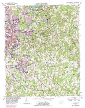
High Point East Topo Map North Carolina
To zoom in, hover over the map of High Point East
USGS Topo Quad 35079h8 - 1:24,000 scale
| Topo Map Name: | High Point East |
| USGS Topo Quad ID: | 35079h8 |
| Print Size: | ca. 21 1/4" wide x 27" high |
| Southeast Coordinates: | 35.875° N latitude / 79.875° W longitude |
| Map Center Coordinates: | 35.9375° N latitude / 79.9375° W longitude |
| U.S. State: | NC |
| Filename: | o35079h8.jpg |
| Download Map JPG Image: | High Point East topo map 1:24,000 scale |
| Map Type: | Topographic |
| Topo Series: | 7.5´ |
| Map Scale: | 1:24,000 |
| Source of Map Images: | United States Geological Survey (USGS) |
| Alternate Map Versions: |
High Point East NC 1950, updated 1964 Download PDF Buy paper map High Point East NC 1950, updated 1970 Download PDF Buy paper map High Point East NC 1950, updated 1983 Download PDF Buy paper map High Point East NC 1951 Download PDF Buy paper map High Point East NC 1993, updated 1999 Download PDF Buy paper map High Point East NC 2002, updated 2004 Download PDF Buy paper map High Point East NC 2010 Download PDF Buy paper map High Point East NC 2013 Download PDF Buy paper map High Point East NC 2016 Download PDF Buy paper map |
1:24,000 Topo Quads surrounding High Point East
> Back to 35079e1 at 1:100,000 scale
> Back to 35078a1 at 1:250,000 scale
> Back to U.S. Topo Maps home
High Point East topo map: Gazetteer
High Point East: Airports
Darr Field elevation 249m 816′High Point East: Dams
Burges Lake Dam elevation 247m 810′High Point Municipal Dam elevation 231m 757′
Jamestown Quarry Dam elevation 228m 748′
King Lake Dam elevation 230m 754′
Linthicum Lake Dam elevation 239m 784′
Owens Lake Dam elevation 258m 846′
Ranch Lake Dam elevation 236m 774′
Thompson Lake Dam elevation 259m 849′
High Point East: Lakes
Jackson Lake elevation 227m 744′High Point East: Parks
Allen Jay Park elevation 244m 800′Brentwood Park elevation 253m 830′
Cedron Park elevation 250m 820′
Eastwood Park elevation 247m 810′
Five Points Park elevation 273m 895′
McCain Park elevation 264m 866′
Washington Terrace Park elevation 264m 866′
High Point East: Populated Places
Allen Jay elevation 251m 823′Archdale elevation 264m 866′
Bakertown elevation 257m 843′
Freeman Mill elevation 210m 688′
Jamestown elevation 242m 793′
Kirkman Crossroad elevation 248m 813′
Melborne Heights elevation 267m 875′
Miles Crossroad elevation 237m 777′
Oakdale elevation 226m 741′
Progress elevation 250m 820′
Ravenwood elevation 247m 810′
Robins Nest elevation 243m 797′
Roxana elevation 243m 797′
Sherwood Village elevation 253m 830′
Springfield elevation 254m 833′
Stones Throw elevation 212m 695′
Trinity elevation 245m 803′
Trinity Park elevation 229m 751′
Westwood elevation 262m 859′
High Point East: Reservoirs
Burges Lake elevation 247m 810′High Point Lake elevation 231m 757′
Jamestown Quarry Lake elevation 228m 748′
King Lake elevation 230m 754′
Kivett Lake elevation 240m 787′
Linthicum Lake elevation 239m 784′
Owens Lake elevation 258m 846′
Ranch Lake elevation 236m 774′
Triangle Lake elevation 240m 787′
High Point East: Springs
Hayworth Spring elevation 249m 816′High Point East: Streams
Boulding Branch elevation 232m 761′Bull Run elevation 217m 711′
Copper Branch elevation 209m 685′
Jenny Branch elevation 221m 725′
Mile Branch elevation 212m 695′
Richland Creek elevation 205m 672′
Taylor Branch elevation 208m 682′
West Fork Deep River elevation 230m 754′
High Point East digital topo map on disk
Buy this High Point East topo map showing relief, roads, GPS coordinates and other geographical features, as a high-resolution digital map file on DVD:
South Carolina, Western North Carolina & Northeastern Georgia
Buy digital topo maps: South Carolina, Western North Carolina & Northeastern Georgia


