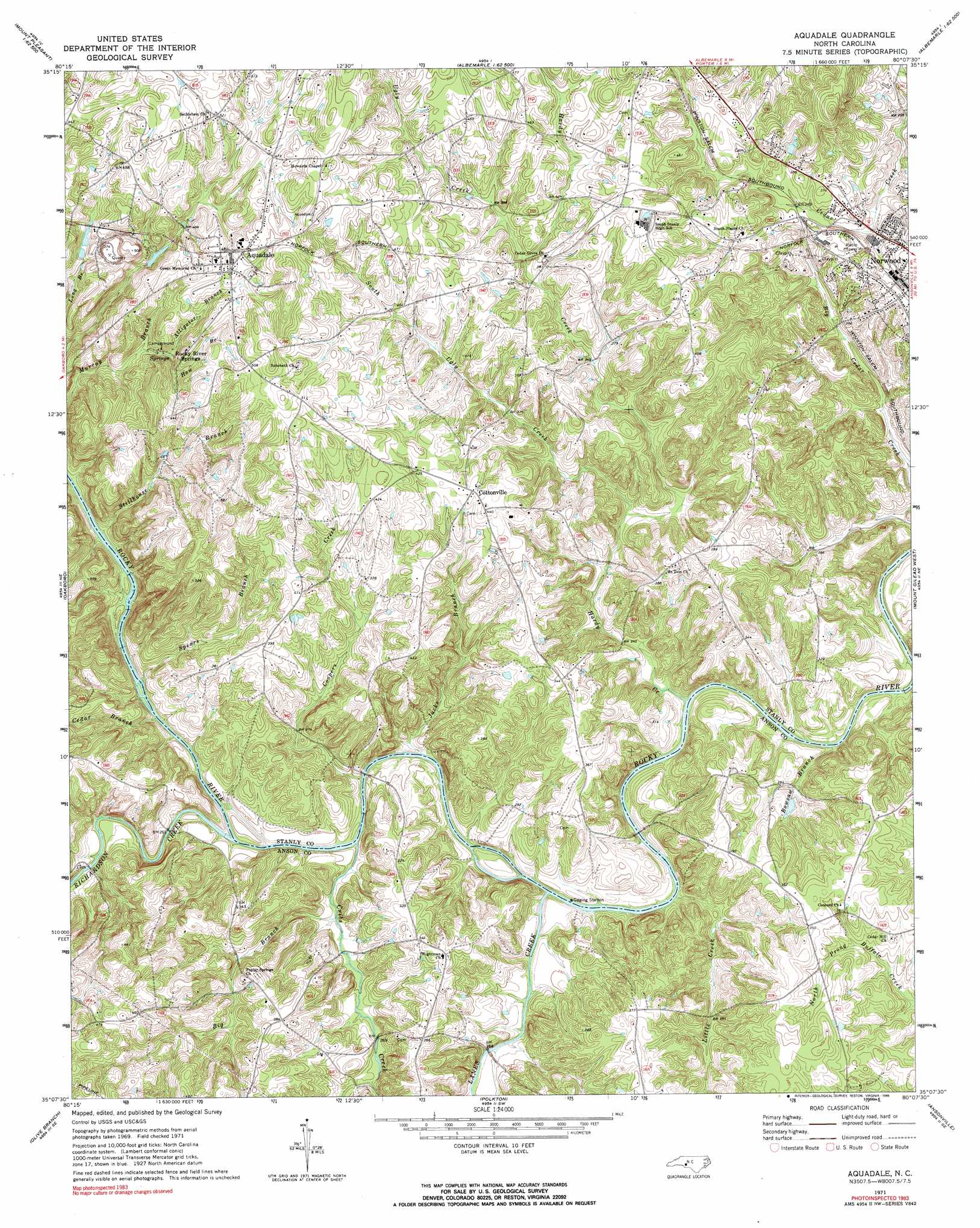
Aquadale Topo Map North Carolina
To zoom in, hover over the map of Aquadale
USGS Topo Quad 35080b2 - 1:24,000 scale
| Topo Map Name: | Aquadale |
| USGS Topo Quad ID: | 35080b2 |
| Print Size: | ca. 21 1/4" wide x 27" high |
| Southeast Coordinates: | 35.125° N latitude / 80.125° W longitude |
| Map Center Coordinates: | 35.1875° N latitude / 80.1875° W longitude |
| U.S. State: | NC |
| Filename: | o35080b2.jpg |
| Download Map JPG Image: | Aquadale topo map 1:24,000 scale |
| Map Type: | Topographic |
| Topo Series: | 7.5´ |
| Map Scale: | 1:24,000 |
| Source of Map Images: | United States Geological Survey (USGS) |
| Alternate Map Versions: |
Aquadale NC 1971, updated 1973 Download PDF Buy paper map Aquadale NC 1971, updated 1990 Download PDF Buy paper map Aquadale NC 2002, updated 2003 Download PDF Buy paper map Aquadale NC 2010 Download PDF Buy paper map Aquadale NC 2013 Download PDF Buy paper map Aquadale NC 2016 Download PDF Buy paper map |
1:24,000 Topo Quads surrounding Aquadale
Mount Pleasant |
Richfield |
New London |
Badin |
Lovejoy |
Locust |
Frog Pond |
Albemarle |
Morrow Mountain |
Troy |
Stanfield |
Oakboro |
Aquadale |
Mount Gilead West |
Mount Gilead East |
Watson |
Olive Branch |
Polkton |
Ansonville |
Mangum |
Wingate |
Marshville |
Russellville |
Wadesboro |
Lilesville |
> Back to 35080a1 at 1:100,000 scale
> Back to 35080a1 at 1:250,000 scale
> Back to U.S. Topo Maps home
Aquadale topo map: Gazetteer
Aquadale: Dams
Long Branch Reservoir Dam elevation 137m 449′Stump Pond Dam elevation 132m 433′
Aquadale: Populated Places
Abecrumby (historical) elevation 110m 360′Aquadale elevation 149m 488′
Cottonville elevation 128m 419′
Roper (historical) elevation 69m 226′
Aquadale: Reservoirs
Long Branch Reservoir elevation 137m 449′Stump Pond elevation 132m 433′
Aquadale: Springs
Rocky River Springs elevation 113m 370′Aquadale: Streams
Alligator Branch elevation 104m 341′Big Branch elevation 72m 236′
Bowsaw Branch elevation 61m 200′
Cedar Branch elevation 73m 239′
Coopers Creek elevation 68m 223′
Cribs Creek elevation 71m 232′
Hardy Creek elevation 64m 209′
Haw Branch elevation 118m 387′
Jacks Branch elevation 137m 449′
Lanes Creek elevation 65m 213′
Little Creek elevation 64m 209′
Richardson Creek elevation 70m 229′
South Ugly Creek elevation 158m 518′
Spears Branch elevation 73m 239′
Stillhouse Branch elevation 78m 255′
Ugly Creek elevation 118m 387′
Aquadale digital topo map on disk
Buy this Aquadale topo map showing relief, roads, GPS coordinates and other geographical features, as a high-resolution digital map file on DVD:
South Carolina, Western North Carolina & Northeastern Georgia
Buy digital topo maps: South Carolina, Western North Carolina & Northeastern Georgia