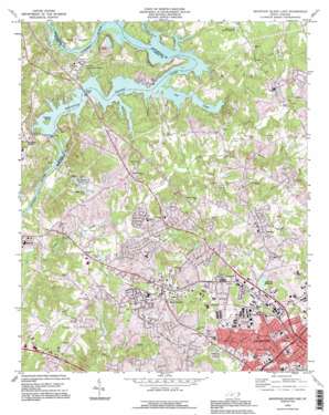
Mountain Island Lake Topo Map North Carolina
To zoom in, hover over the map of Mountain Island Lake
USGS Topo Quad 35080c8 - 1:24,000 scale
| Topo Map Name: | Mountain Island Lake |
| USGS Topo Quad ID: | 35080c8 |
| Print Size: | ca. 21 1/4" wide x 27" high |
| Southeast Coordinates: | 35.25° N latitude / 80.875° W longitude |
| Map Center Coordinates: | 35.3125° N latitude / 80.9375° W longitude |
| U.S. State: | NC |
| Filename: | o35080c8.jpg |
| Download Map JPG Image: | Mountain Island Lake topo map 1:24,000 scale |
| Map Type: | Topographic |
| Topo Series: | 7.5´ |
| Map Scale: | 1:24,000 |
| Source of Map Images: | United States Geological Survey (USGS) |
| Alternate Map Versions: |
Paw Creek NC 1948, updated 1952 Download PDF Buy paper map Mountain Island Lake NC 1969, updated 1973 Download PDF Buy paper map Mountain Island Lake NC 1969, updated 1988 Download PDF Buy paper map Mountain Island Lake NC 1993, updated 1996 Download PDF Buy paper map Mountain Island Lake NC 1997, updated 1999 Download PDF Buy paper map Mountain Island Lake NC 2010 Download PDF Buy paper map Mountain Island Lake NC 2013 Download PDF Buy paper map Mountain Island Lake NC 2016 Download PDF Buy paper map |
1:24,000 Topo Quads surrounding Mountain Island Lake
> Back to 35080a1 at 1:100,000 scale
> Back to 35080a1 at 1:250,000 scale
> Back to U.S. Topo Maps home
Mountain Island Lake topo map: Gazetteer
Mountain Island Lake: Bridges
Rozzelle Bridge elevation 196m 643′Mountain Island Lake: Dams
Brinkleys Twin Lakes Number One Dam elevation 198m 649′Harwood Lake Dam elevation 195m 639′
Mecklenburg Wildlife Club Lake Dam elevation 193m 633′
Mountain Island Reservoir Dam elevation 196m 643′
Mountain Island Lake: Islands
Mountain Island elevation 212m 695′Mountain Island Lake: Lakes
Crescent Pond elevation 229m 751′Mountain Island Lake: Parks
Little Rock Road District Park elevation 197m 646′Mountain Island Lake: Populated Places
Arlington elevation 220m 721′Brookfield elevation 230m 754′
Chateau Woods elevation 240m 787′
Chemway elevation 237m 777′
Coulwood elevation 196m 643′
Coulwood Hills elevation 210m 688′
Deerwood elevation 233m 764′
Forest Pawtuckett elevation 222m 728′
Forest Rawtucket elevation 214m 702′
Homestead elevation 250m 820′
Hope Farm elevation 200m 656′
Hoskins elevation 229m 751′
Kellyville (historical) elevation 189m 620′
Lewis elevation 213m 698′
Martindale (historical) elevation 201m 659′
Mountain Island elevation 212m 695′
Oakdale elevation 245m 803′
Oakdale Forest elevation 233m 764′
Paw Creek elevation 234m 767′
Pine Island elevation 207m 679′
Pinoca (historical) elevation 238m 780′
Rhyne elevation 207m 679′
Shuffletown elevation 226m 741′
Sodyeco elevation 190m 623′
Thomasboro elevation 224m 734′
Toddville elevation 235m 770′
Town Park elevation 214m 702′
Tuskasaga (historical) elevation 199m 652′
Twins Estates elevation 202m 662′
Westbourne elevation 224m 734′
Westchester elevation 212m 695′
Westwood Forest elevation 222m 728′
White Oak Park elevation 206m 675′
Wildwood elevation 212m 695′
Woodford Green elevation 208m 682′
Woodlea elevation 206m 675′
Mountain Island Lake: Reservoirs
Brinkleys Twin Lakes elevation 209m 685′Brinkleys Twin Lakes Number One elevation 198m 649′
Charlotte Reservoir elevation 248m 813′
Harwood Lakes elevation 195m 639′
Lake Kathleen elevation 183m 600′
Mecklenberg Wildlife Club Lake elevation 193m 633′
Mountain Island Lake elevation 196m 643′
Thomas Pond elevation 206m 675′
Mountain Island Lake: Streams
Gar Creek elevation 196m 643′Gum Branch elevation 192m 629′
Gutter Branch elevation 197m 646′
McDowell Creek elevation 196m 643′
McIntyre Creek elevation 200m 656′
Mountain Island Lake digital topo map on disk
Buy this Mountain Island Lake topo map showing relief, roads, GPS coordinates and other geographical features, as a high-resolution digital map file on DVD:
South Carolina, Western North Carolina & Northeastern Georgia
Buy digital topo maps: South Carolina, Western North Carolina & Northeastern Georgia


