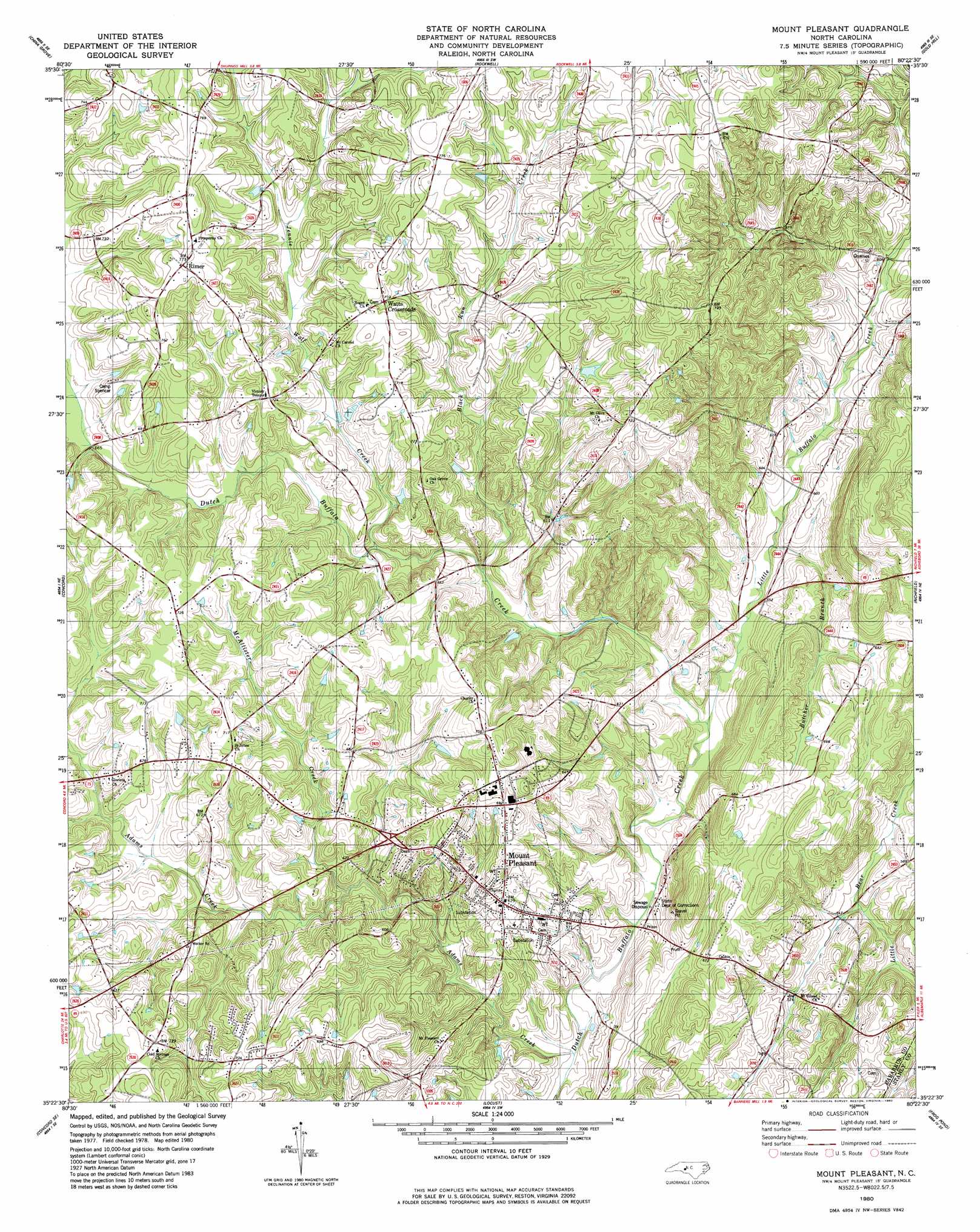
Mount Pleasant Topo Map North Carolina
To zoom in, hover over the map of Mount Pleasant
USGS Topo Quad 35080d4 - 1:24,000 scale
| Topo Map Name: | Mount Pleasant |
| USGS Topo Quad ID: | 35080d4 |
| Print Size: | ca. 21 1/4" wide x 27" high |
| Southeast Coordinates: | 35.375° N latitude / 80.375° W longitude |
| Map Center Coordinates: | 35.4375° N latitude / 80.4375° W longitude |
| U.S. State: | NC |
| Filename: | o35080d4.jpg |
| Download Map JPG Image: | Mount Pleasant topo map 1:24,000 scale |
| Map Type: | Topographic |
| Topo Series: | 7.5´ |
| Map Scale: | 1:24,000 |
| Source of Map Images: | United States Geological Survey (USGS) |
| Alternate Map Versions: |
Mount Pleasant NC 1980, updated 1980 Download PDF Buy paper map Mount Pleasant NC 2002, updated 2003 Download PDF Buy paper map Mount Pleasant NC 2010 Download PDF Buy paper map Mount Pleasant NC 2013 Download PDF Buy paper map Mount Pleasant NC 2016 Download PDF Buy paper map |
1:24,000 Topo Quads surrounding Mount Pleasant
Cleveland |
Rowan Mills |
Salisbury |
Southmont |
Denton Nw |
Enochville |
China Grove |
Rockwell |
Gold Hill |
High Rock |
Kannapolis |
Concord |
Mount Pleasant |
Richfield |
New London |
Harrisburg |
Concord Se |
Locust |
Frog Pond |
Albemarle |
Mint Hill |
Midland |
Stanfield |
Oakboro |
Aquadale |
> Back to 35080a1 at 1:100,000 scale
> Back to 35080a1 at 1:250,000 scale
> Back to U.S. Topo Maps home
Mount Pleasant topo map: Gazetteer
Mount Pleasant: Airports
Concord Airport (historical) elevation 218m 715′Mount Pleasant: Parks
Mount Pleasant Community Park elevation 178m 583′Mount Pleasant: Populated Places
Mount Pleasant elevation 191m 626′Rimer elevation 230m 754′
Watts Crossroads elevation 220m 721′
Mount Pleasant: Streams
Adams Creek elevation 158m 518′Black Run Creek elevation 175m 574′
Butcher Branch elevation 166m 544′
Jennie Wolf Creek elevation 183m 600′
Little Buffalo Creek elevation 159m 521′
McAllister Creek elevation 176m 577′
Mount Pleasant digital topo map on disk
Buy this Mount Pleasant topo map showing relief, roads, GPS coordinates and other geographical features, as a high-resolution digital map file on DVD:
South Carolina, Western North Carolina & Northeastern Georgia
Buy digital topo maps: South Carolina, Western North Carolina & Northeastern Georgia