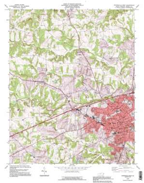
Statesville West Topo Map North Carolina
To zoom in, hover over the map of Statesville West
USGS Topo Quad 35080g8 - 1:24,000 scale
| Topo Map Name: | Statesville West |
| USGS Topo Quad ID: | 35080g8 |
| Print Size: | ca. 21 1/4" wide x 27" high |
| Southeast Coordinates: | 35.75° N latitude / 80.875° W longitude |
| Map Center Coordinates: | 35.8125° N latitude / 80.9375° W longitude |
| U.S. State: | NC |
| Filename: | o35080g8.jpg |
| Download Map JPG Image: | Statesville West topo map 1:24,000 scale |
| Map Type: | Topographic |
| Topo Series: | 7.5´ |
| Map Scale: | 1:24,000 |
| Source of Map Images: | United States Geological Survey (USGS) |
| Alternate Map Versions: |
Statesville West NC 1969, updated 1972 Download PDF Buy paper map Statesville West NC 1976, updated 1979 Download PDF Buy paper map Statesville West NC 1993, updated 1996 Download PDF Buy paper map Statesville West NC 2002, updated 2005 Download PDF Buy paper map Statesville West NC 2010 Download PDF Buy paper map Statesville West NC 2013 Download PDF Buy paper map Statesville West NC 2016 Download PDF Buy paper map |
1:24,000 Topo Quads surrounding Statesville West
> Back to 35080e1 at 1:100,000 scale
> Back to 35080a1 at 1:250,000 scale
> Back to U.S. Topo Maps home
Statesville West topo map: Gazetteer
Statesville West: Airports
Statesville Municipal Airport elevation 279m 915′Statesville West: Dams
J W Lackey Dam elevation 268m 879′Kenneth Raymer Lake Dam elevation 252m 826′
T S Stewart Dam elevation 275m 902′
Woods Drive Dam elevation 250m 820′
Statesville West: Parks
Abernathy Ball Field elevation 285m 935′Anderson Park elevation 270m 885′
Colliers Lake Park elevation 256m 839′
Grace Park elevation 291m 954′
I-40 Park elevation 265m 869′
Lakewood Park elevation 259m 849′
Watts Park elevation 263m 862′
Statesville West: Populated Places
Ashbrook Park elevation 261m 856′Beverly Heights elevation 274m 898′
Bloomfield elevation 277m 908′
Bostian Heights elevation 272m 892′
Bristol Terrace elevation 276m 905′
Celeste Hinkel elevation 295m 967′
Chipley Park elevation 277m 908′
Cloverdale elevation 279m 915′
Cowin (historical) elevation 239m 784′
Greencrest elevation 277m 908′
Hickory Hills elevation 266m 872′
Kentwood Park elevation 279m 915′
Kingswood elevation 278m 912′
Lakeside elevation 257m 843′
Liberty Hill (historical) elevation 302m 990′
Loray elevation 302m 990′
Monticello elevation 286m 938′
Monticello Heights elevation 293m 961′
Northmont elevation 287m 941′
Northview elevation 263m 862′
Oakland Heights elevation 281m 921′
Starmount elevation 264m 866′
Statesville elevation 278m 912′
Statesville West elevation 273m 895′
Washington Heights elevation 269m 882′
Watts (historical) elevation 248m 813′
Wendover Hills elevation 290m 951′
West Statesville elevation 269m 882′
Westover elevation 284m 931′
Westwood elevation 252m 826′
Statesville West: Reservoirs
Kenneth Raymer Lake elevation 252m 826′Noname elevation 268m 879′
Noname elevation 275m 902′
Woods Drive Lake elevation 250m 820′
Statesville West: Streams
Back Creek elevation 245m 803′Brady Branch elevation 261m 856′
Gregory Creek elevation 243m 797′
Morrison Creek elevation 238m 780′
Statesville West digital topo map on disk
Buy this Statesville West topo map showing relief, roads, GPS coordinates and other geographical features, as a high-resolution digital map file on DVD:
South Carolina, Western North Carolina & Northeastern Georgia
Buy digital topo maps: South Carolina, Western North Carolina & Northeastern Georgia


