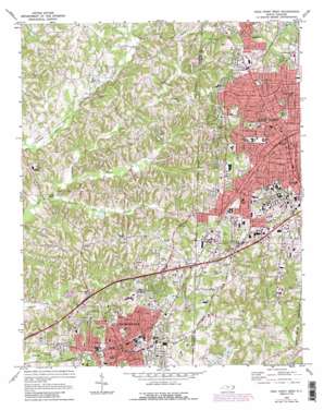
High Point West Topo Map North Carolina
To zoom in, hover over the map of High Point West
USGS Topo Quad 35080h1 - 1:24,000 scale
| Topo Map Name: | High Point West |
| USGS Topo Quad ID: | 35080h1 |
| Print Size: | ca. 21 1/4" wide x 27" high |
| Southeast Coordinates: | 35.875° N latitude / 80° W longitude |
| Map Center Coordinates: | 35.9375° N latitude / 80.0625° W longitude |
| U.S. State: | NC |
| Filename: | o35080h1.jpg |
| Download Map JPG Image: | High Point West topo map 1:24,000 scale |
| Map Type: | Topographic |
| Topo Series: | 7.5´ |
| Map Scale: | 1:24,000 |
| Source of Map Images: | United States Geological Survey (USGS) |
| Alternate Map Versions: |
High Point West NC 1949, updated 1952 Download PDF Buy paper map High Point West NC 1949, updated 1964 Download PDF Buy paper map High Point West NC 1969, updated 1973 Download PDF Buy paper map High Point West NC 1969, updated 1987 Download PDF Buy paper map High Point West NC 1977, updated 1979 Download PDF Buy paper map High Point West NC 1993, updated 1999 Download PDF Buy paper map High Point West NC 2010 Download PDF Buy paper map High Point West NC 2013 Download PDF Buy paper map High Point West NC 2016 Download PDF Buy paper map |
1:24,000 Topo Quads surrounding High Point West
> Back to 35080e1 at 1:100,000 scale
> Back to 35080a1 at 1:250,000 scale
> Back to U.S. Topo Maps home
High Point West topo map: Gazetteer
High Point West: Airports
Brower Field elevation 261m 856′Mendenhall Airport elevation 293m 961′
Midway Airport elevation 263m 862′
High Point West: Dams
Davis Dam Number One elevation 253m 830′Davis Dam Number Two elevation 247m 810′
Merry Hills Lake Dam elevation 235m 770′
High Point West: Parks
Armstrong Park elevation 265m 869′Doak Park elevation 255m 836′
Finch Field elevation 264m 866′
Harvell Park elevation 275m 902′
Hedgecock Park elevation 253m 830′
Memorial Park elevation 247m 810′
High Point West: Populated Places
Brummels (historical) elevation 242m 793′Erwin Heights elevation 255m 836′
High Point elevation 281m 921′
Lodonberry Estates elevation 254m 833′
Oakview elevation 272m 892′
Pennfield (historical) elevation 246m 807′
Thomasville elevation 259m 849′
High Point West: Post Offices
Thomasville Post Office elevation 259m 849′High Point West: Reservoirs
Davis Lake Number One elevation 253m 830′Davis Lake Number Two elevation 247m 810′
Lower Lake elevation 256m 839′
Merry Hills Lake elevation 235m 770′
Middle Lake elevation 263m 862′
Upper Lake elevation 270m 885′
High Point West: Streams
Hanks Branch elevation 212m 695′Kennedy Mill Creek elevation 213m 698′
Payne Creek elevation 215m 705′
Spurgeon Creek elevation 221m 725′
High Point West digital topo map on disk
Buy this High Point West topo map showing relief, roads, GPS coordinates and other geographical features, as a high-resolution digital map file on DVD:
South Carolina, Western North Carolina & Northeastern Georgia
Buy digital topo maps: South Carolina, Western North Carolina & Northeastern Georgia


