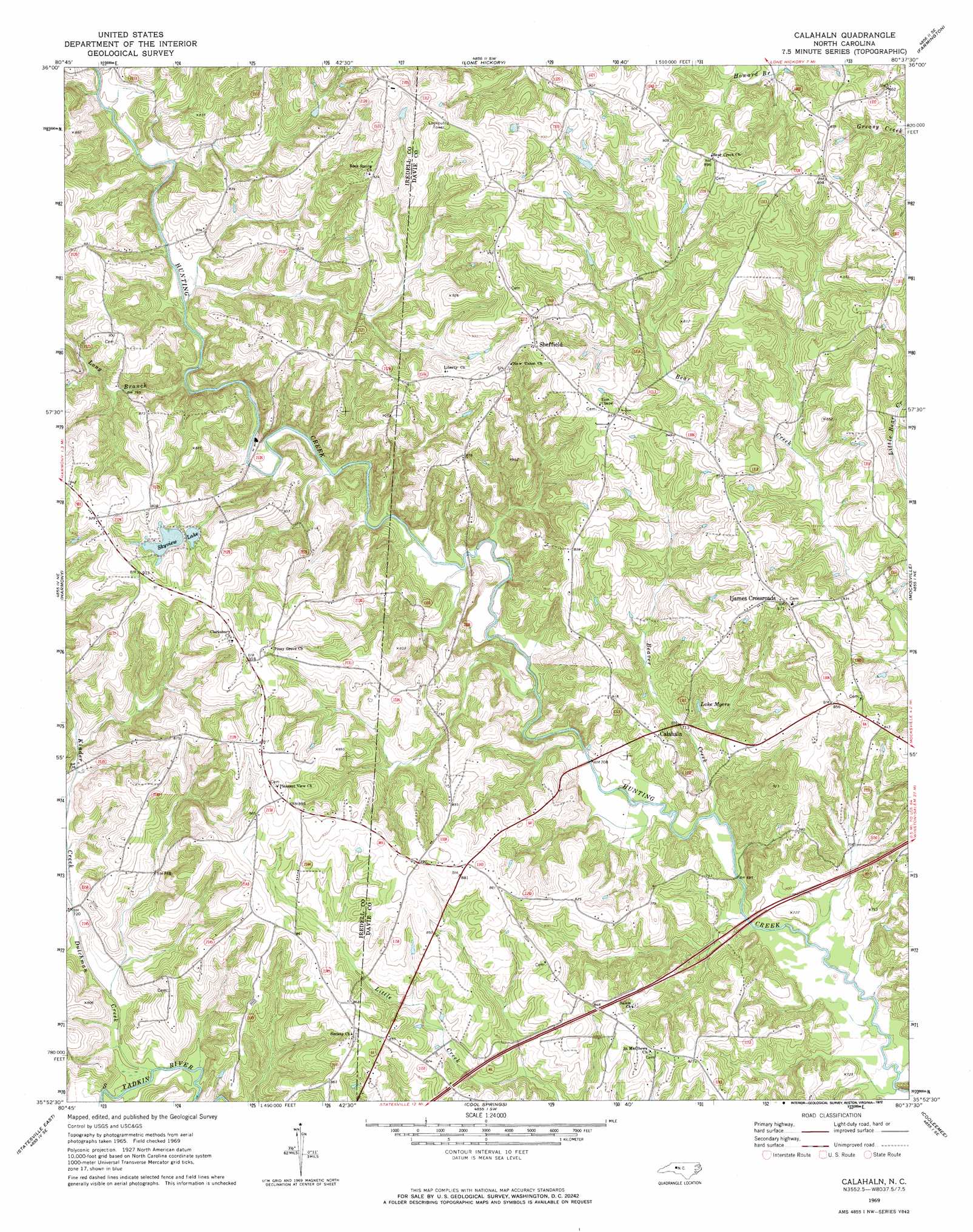
Calahaln Topo Map North Carolina
To zoom in, hover over the map of Calahaln
USGS Topo Quad 35080h6 - 1:24,000 scale
| Topo Map Name: | Calahaln |
| USGS Topo Quad ID: | 35080h6 |
| Print Size: | ca. 21 1/4" wide x 27" high |
| Southeast Coordinates: | 35.875° N latitude / 80.625° W longitude |
| Map Center Coordinates: | 35.9375° N latitude / 80.6875° W longitude |
| U.S. State: | NC |
| Filename: | o35080h6.jpg |
| Download Map JPG Image: | Calahaln topo map 1:24,000 scale |
| Map Type: | Topographic |
| Topo Series: | 7.5´ |
| Map Scale: | 1:24,000 |
| Source of Map Images: | United States Geological Survey (USGS) |
| Alternate Map Versions: |
Calahaln NC 1969, updated 1972 Download PDF Buy paper map Calahaln NC 2010 Download PDF Buy paper map Calahaln NC 2013 Download PDF Buy paper map Calahaln NC 2016 Download PDF Buy paper map |
1:24,000 Topo Quads surrounding Calahaln
Ronda |
Elkin South |
Yadkinville |
East Bend |
Vienna |
Osbornville |
Brooks Crossroads |
Lone Hickory |
Farmington |
Clemmons |
Central |
Harmony |
Calahaln |
Mocksville |
Advance |
Statesville West |
Statesville East |
Cool Springs |
Cooleemee |
Churchland |
Troutman |
Shepherds |
Cleveland |
Rowan Mills |
Salisbury |
> Back to 35080e1 at 1:100,000 scale
> Back to 35080a1 at 1:250,000 scale
> Back to U.S. Topo Maps home
Calahaln topo map: Gazetteer
Calahaln: Dams
Skyview Lake Dam Upper elevation 251m 823′Skyview Lake Lower Dam elevation 255m 836′
Calahaln: Lakes
Lake Myers elevation 224m 734′Calahaln: Populated Places
Calahaln elevation 233m 764′Gather (historical) elevation 243m 797′
Houstonville (historical) elevation 276m 905′
Ijames Crossroads elevation 267m 875′
Oakland Heights elevation 264m 866′
Sheffield elevation 287m 941′
V Point elevation 275m 902′
Calahaln: Post Offices
County Line Post Office (historical) elevation 265m 869′Calahaln: Reservoirs
Skyview Lake elevation 261m 856′Skyview Lake Lower elevation 255m 836′
Skyview Lake Upper elevation 251m 823′
Calahaln: Streams
Beaver Creek elevation 209m 685′Dutchman Creek elevation 210m 688′
Kinder Creek elevation 217m 711′
Long Branch elevation 220m 721′
Calahaln: Summits
Calahaln Mountain elevation 253m 830′Calahaln digital topo map on disk
Buy this Calahaln topo map showing relief, roads, GPS coordinates and other geographical features, as a high-resolution digital map file on DVD:
South Carolina, Western North Carolina & Northeastern Georgia
Buy digital topo maps: South Carolina, Western North Carolina & Northeastern Georgia