Cowpens Topo Map South Carolina
To zoom in, hover over the map of Cowpens
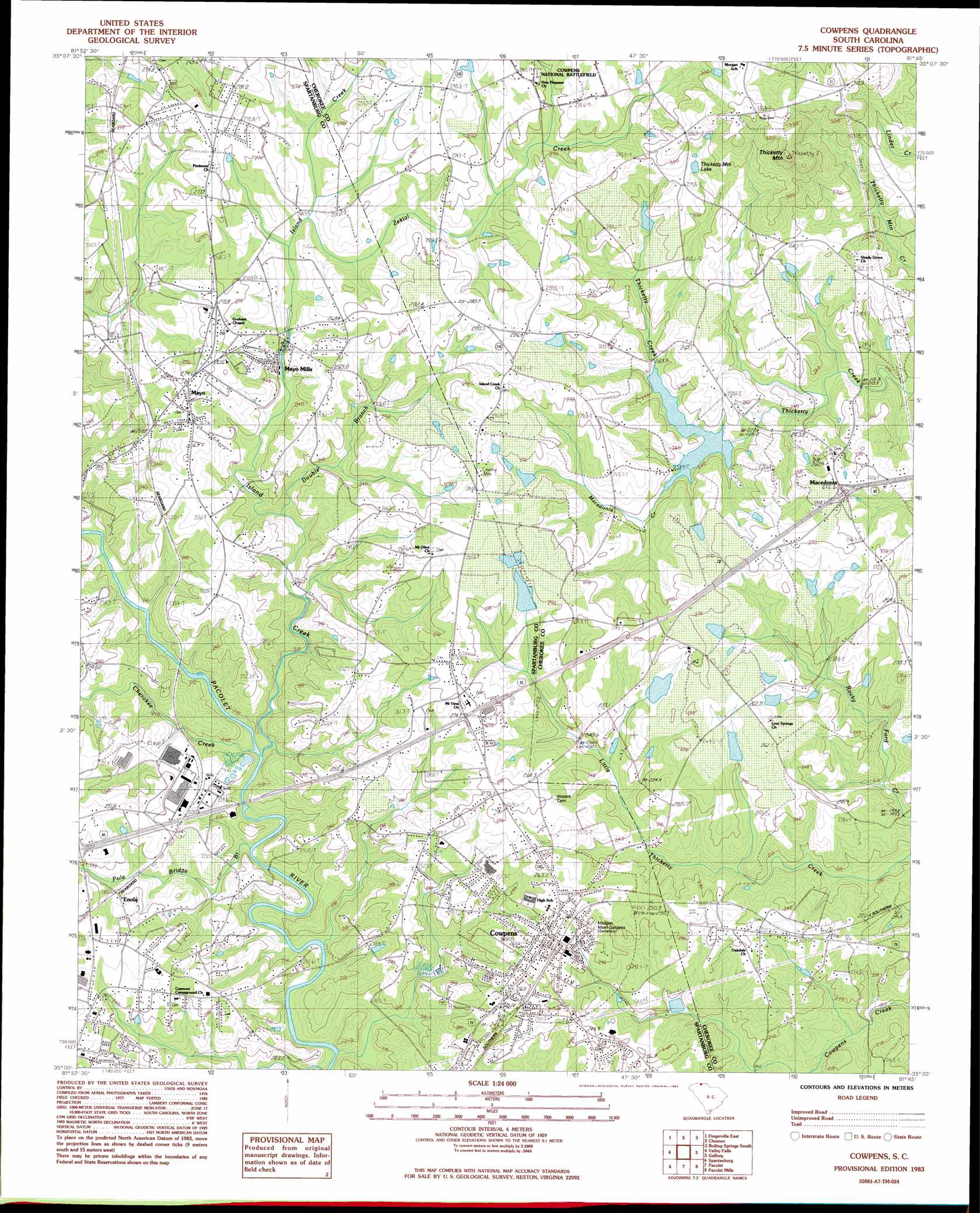
USGS Topo Quad 35081a7 - 1:24,000 scale
| Topo Map Name: | Cowpens |
| USGS Topo Quad ID: | 35081a7 |
| Print Size: | ca. 21 1/4" wide x 27" high |
| Southeast Coordinates: | 35° N latitude / 81.75° W longitude |
| Map Center Coordinates: | 35.0625° N latitude / 81.8125° W longitude |
| U.S. State: | SC |
| Filename: | o35081a7.jpg |
| Download Map JPG Image: | Cowpens topo map 1:24,000 scale |
| Map Type: | Topographic |
| Topo Series: | 7.5´ |
| Map Scale: | 1:24,000 |
| Source of Map Images: | United States Geological Survey (USGS) |
| Alternate Map Versions: |
Cowpens SC 1983, updated 1983 Download PDF Buy paper map Cowpens SC 1983, updated 1983 Download PDF Buy paper map Cowpens SC 2011 Download PDF Buy paper map Cowpens SC 2014 Download PDF Buy paper map |
1:24,000 Topo Quads surrounding Cowpens
Pea Ridge |
Rutherfordton South |
Forest City |
Boiling Springs North |
Shelby |
Fingerville West |
Fingerville East |
Chesnee |
Boiling Springs South |
Blacksburg North |
Inman |
Valley Falls |
Cowpens |
Gaffney |
Blacksburg South |
Wellford |
Spartanburg |
Pacolet |
Pacolet Mills |
Wilkinsville |
Reidville |
Moore |
Glenn Springs |
Jonesville |
Kelton |
> Back to 35081a1 at 1:100,000 scale
> Back to 35080a1 at 1:250,000 scale
> Back to U.S. Topo Maps home
Cowpens topo map: Gazetteer
Cowpens: Crossings
Interchange 83 elevation 271m 889′Interchange 86 elevation 270m 885′
Cowpens: Dams
South Carolina Noname 11012 D-3403 Dam elevation 253m 830′South Carolina Noname 11013 D-1416 Dam elevation 253m 830′
South Carolina Noname 11014 D-3399 Dam elevation 262m 859′
South Carolina Noname 11018 D-3402 Dam elevation 257m 843′
Sunny Slopes Pond Number One Dam D-3368 elevation 270m 885′
Sunny Slopes Pond Number Two Dam D-3367 elevation 270m 885′
Thicketty Creek WCD Dam Number 26 elevation 226m 741′
W Cash Pond Dam D-3325 elevation 252m 826′
Cowpens: Populated Places
Bellview Acres elevation 247m 810′Cannons Camp Ground elevation 253m 830′
Clearview Heights elevation 247m 810′
Converse Road Mobile Home Park elevation 222m 728′
Cowpens elevation 262m 859′
Enola elevation 257m 843′
Love Springs elevation 260m 853′
Macedonia elevation 269m 882′
Mayo elevation 271m 889′
Mayo Mills elevation 249m 816′
Reynolds Mobile Home Park elevation 263m 862′
Riverview Park elevation 232m 761′
Springdale Estates elevation 263m 862′
Whitlock Park elevation 254m 833′
Cowpens: Post Offices
Cowpens Post Office elevation 263m 862′Cowpens: Reservoirs
Little Thicketty Creek Pond elevation 270m 885′Thicketty Creek WCD Lake Number 26 elevation 226m 741′
Thicketty Mountain Lake elevation 283m 928′
Trib Zekial Creek Pond elevation 252m 826′
Cowpens: Streams
Cherokee Creek elevation 199m 652′Double Branch elevation 213m 698′
Island Creek elevation 194m 636′
Long Branch of Island Creek elevation 261m 856′
Pole Bridge Branch elevation 193m 633′
Zekial Creek elevation 245m 803′
Cowpens: Summits
Thicketty Mountain elevation 364m 1194′Cowpens digital topo map on disk
Buy this Cowpens topo map showing relief, roads, GPS coordinates and other geographical features, as a high-resolution digital map file on DVD:
South Carolina, Western North Carolina & Northeastern Georgia
Buy digital topo maps: South Carolina, Western North Carolina & Northeastern Georgia