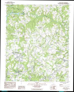
Valley Falls Topo Map South Carolina
To zoom in, hover over the map of Valley Falls
USGS Topo Quad 35081a8 - 1:24,000 scale
| Topo Map Name: | Valley Falls |
| USGS Topo Quad ID: | 35081a8 |
| Print Size: | ca. 21 1/4" wide x 27" high |
| Southeast Coordinates: | 35° N latitude / 81.875° W longitude |
| Map Center Coordinates: | 35.0625° N latitude / 81.9375° W longitude |
| U.S. State: | SC |
| Filename: | o35081a8.jpg |
| Download Map JPG Image: | Valley Falls topo map 1:24,000 scale |
| Map Type: | Topographic |
| Topo Series: | 7.5´ |
| Map Scale: | 1:24,000 |
| Source of Map Images: | United States Geological Survey (USGS) |
| Alternate Map Versions: |
Valley Falls SC 1983, updated 1983 Download PDF Buy paper map Valley Falls SC 2011 Download PDF Buy paper map Valley Falls SC 2014 Download PDF Buy paper map |
1:24,000 Topo Quads surrounding Valley Falls
> Back to 35081a1 at 1:100,000 scale
> Back to 35080a1 at 1:250,000 scale
> Back to U.S. Topo Maps home
Valley Falls topo map: Gazetteer
Valley Falls: Airports
Pearsons Farm Airport elevation 279m 915′Valley Falls: Bridges
Paris Bridge elevation 219m 718′Sandy Ford Bridge elevation 208m 682′
Valley Falls: Crossings
Cothes Ford elevation 209m 685′Interchange 76 elevation 251m 823′
Interchange 77 elevation 264m 866′
Interchange 78 elevation 254m 833′
Interchange 79 elevation 247m 810′
Valley Falls: Dams
A B Johnson Pond Dam D-3335 elevation 253m 830′E W Nowland Pond Dam D-3333 elevation 266m 872′
Flatwood Lake Dam D-3334 elevation 258m 846′
J C Petty Pond Dam D-3331 elevation 259m 849′
South Carolina Noname 42013 Dam elevation 253m 830′
South Pacolet River Reservoir Number One D-3324 Dam elevation 239m 784′
Spring Lake Pond Dam D-3330 elevation 264m 866′
Thomas Cantrell Pond Dam D-3258 elevation 244m 800′
Tr Casey Creek Pond Dam D-3332 elevation 236m 774′
Tr Fawn Branch Pond Dam D-3329 elevation 272m 892′
Tr South Pacolet River Dam D-3323 elevation 258m 846′
Valley Falls: Lakes
Rainbow Lake elevation 229m 751′Valley Falls: Populated Places
Beverly Woods elevation 257m 843′Boiling Springs elevation 282m 925′
Canterbury Heights elevation 258m 846′
Carlisle elevation 289m 948′
Cherokee Springs elevation 236m 774′
Clearview Heights elevation 272m 892′
Diamond J Mobile Home Park elevation 273m 895′
Ferndale elevation 254m 833′
Fosters Grove elevation 264m 866′
Kentwood elevation 240m 787′
Lakeview Manor elevation 261m 856′
Laurelwood elevation 265m 869′
Luray Hills elevation 272m 892′
Lynwood elevation 267m 875′
Mason Estates elevation 275m 902′
McGreegor Downs elevation 246m 807′
Meadow Spring elevation 260m 853′
Midland Estates elevation 274m 898′
Mountain View elevation 280m 918′
Mountainbrook elevation 264m 866′
North Hill Acres elevation 260m 853′
North Hills elevation 243m 797′
Northbrook Park elevation 258m 846′
Northgate elevation 297m 974′
Northwood elevation 289m 948′
Panorama Estates elevation 273m 895′
Peach Valley Fairway Estates elevation 268m 879′
Peachtree Gardens elevation 268m 879′
Pinebrook Mobile Home Community elevation 252m 826′
Quail Ridge elevation 262m 859′
Rainbow Park elevation 288m 944′
Sherman Park elevation 269m 882′
Shoally Creek elevation 257m 843′
Spring Hills elevation 274m 898′
Springlake elevation 276m 905′
Sunnydale Acres elevation 261m 856′
Thorn Ridge Mobile Home Park elevation 251m 823′
Thunderbird Mobile Home Park elevation 250m 820′
Twin Creek elevation 258m 846′
Valley Falls elevation 247m 810′
Woodcreek elevation 252m 826′
Valley Falls: Reservoirs
Fairview Lake elevation 271m 889′Flatwood Lake elevation 258m 846′
South Pacolet River Reservoir Number elevation 227m 744′
South Pacolet River Reservoir Number One elevation 239m 784′
Waldrops Lake elevation 256m 839′
Valley Falls: Streams
Adventure Creek elevation 250m 820′Big Shoally Creek elevation 227m 744′
Buck Creek elevation 203m 666′
Carlisle Branch elevation 247m 810′
Casey Creek elevation 206m 675′
Cudds Creek elevation 232m 761′
Fawn Branch elevation 235m 770′
Little Buck Creek elevation 219m 718′
Little Cherokee Creek elevation 224m 734′
Little Shoally Creek elevation 241m 790′
Mud Creek elevation 248m 813′
North Pacolet River elevation 221m 725′
Obed Creek elevation 232m 761′
Rocky Ford Branch elevation 232m 761′
South Pacolet River elevation 227m 744′
Thompson Creek elevation 215m 705′
Valley Falls digital topo map on disk
Buy this Valley Falls topo map showing relief, roads, GPS coordinates and other geographical features, as a high-resolution digital map file on DVD:
South Carolina, Western North Carolina & Northeastern Georgia
Buy digital topo maps: South Carolina, Western North Carolina & Northeastern Georgia


