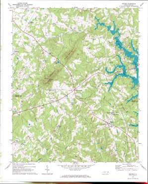
Denver Topo Map North Carolina
To zoom in, hover over the map of Denver
USGS Topo Quad 35081e1 - 1:24,000 scale
| Topo Map Name: | Denver |
| USGS Topo Quad ID: | 35081e1 |
| Print Size: | ca. 21 1/4" wide x 27" high |
| Southeast Coordinates: | 35.5° N latitude / 81° W longitude |
| Map Center Coordinates: | 35.5625° N latitude / 81.0625° W longitude |
| U.S. State: | NC |
| Filename: | o35081e1.jpg |
| Download Map JPG Image: | Denver topo map 1:24,000 scale |
| Map Type: | Topographic |
| Topo Series: | 7.5´ |
| Map Scale: | 1:24,000 |
| Source of Map Images: | United States Geological Survey (USGS) |
| Alternate Map Versions: |
Denver NC 1970, updated 1973 Download PDF Buy paper map Denver NC 1976, updated 1978 Download PDF Buy paper map Denver NC 1993, updated 1996 Download PDF Buy paper map Denver NC 2010 Download PDF Buy paper map Denver NC 2013 Download PDF Buy paper map Denver NC 2016 Download PDF Buy paper map |
1:24,000 Topo Quads surrounding Denver
> Back to 35081e1 at 1:100,000 scale
> Back to 35080a1 at 1:250,000 scale
> Back to U.S. Topo Maps home
Denver topo map: Gazetteer
Denver: Airports
Laneys Airport elevation 302m 990′Little Mountain Airport elevation 302m 990′
Denver: Dams
Jones Lake Dam elevation 308m 1010′Little Mountain Aircraft Dam elevation 284m 931′
Quinlen Lake Dam elevation 278m 912′
Denver: Populated Places
Denver elevation 274m 898′Drums Crossroads elevation 324m 1062′
Killian Crossroads elevation 280m 918′
Olivers Crossroads elevation 331m 1085′
Denver: Ranges
Anderson Mountain elevation 404m 1325′Denver: Reservoirs
Jones Lake elevation 309m 1013′Little Mountain Aircraft Lake elevation 284m 931′
Quinlen Lake elevation 278m 912′
Denver: Springs
Rock Springs elevation 270m 885′Denver: Streams
Mundy Creek elevation 231m 757′Reed Creek elevation 231m 757′
South Fork Mountain Creek elevation 235m 770′
Wilkinson Creek elevation 226m 741′
Denver digital topo map on disk
Buy this Denver topo map showing relief, roads, GPS coordinates and other geographical features, as a high-resolution digital map file on DVD:
South Carolina, Western North Carolina & Northeastern Georgia
Buy digital topo maps: South Carolina, Western North Carolina & Northeastern Georgia


