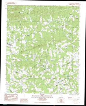
Tigerville Topo Map South Carolina
To zoom in, hover over the map of Tigerville
USGS Topo Quad 35082a3 - 1:24,000 scale
| Topo Map Name: | Tigerville |
| USGS Topo Quad ID: | 35082a3 |
| Print Size: | ca. 21 1/4" wide x 27" high |
| Southeast Coordinates: | 35° N latitude / 82.25° W longitude |
| Map Center Coordinates: | 35.0625° N latitude / 82.3125° W longitude |
| U.S. State: | SC |
| Filename: | o35082a3.jpg |
| Download Map JPG Image: | Tigerville topo map 1:24,000 scale |
| Map Type: | Topographic |
| Topo Series: | 7.5´ |
| Map Scale: | 1:24,000 |
| Source of Map Images: | United States Geological Survey (USGS) |
| Alternate Map Versions: |
Tigerville SC 1983, updated 1983 Download PDF Buy paper map Tigerville SC 1983, updated 1983 Download PDF Buy paper map Tigerville SC 2011 Download PDF Buy paper map Tigerville SC 2014 Download PDF Buy paper map |
1:24,000 Topo Quads surrounding Tigerville
> Back to 35082a1 at 1:100,000 scale
> Back to 35082a1 at 1:250,000 scale
> Back to U.S. Topo Maps home
Tigerville topo map: Gazetteer
Tigerville: Airports
O Neal Field elevation 277m 908′Wilbanks Airport elevation 307m 1007′
Tigerville: Bridges
Campbell Covered Bridge elevation 297m 974′Tigerville: Dams
Anthony Lake Dam Number One D-2885 elevation 295m 967′Anthony Lake Dam Number Two D-2884 elevation 289m 948′
Bryant Pond Dam D-2891 elevation 281m 921′
Hayes Pond Dam D-2867 elevation 300m 984′
L Cooper Pond Dam D-2882 elevation 330m 1082′
Ridgill Lake Dam elevation 414m 1358′
Rudolf Pond Dam D-2849 elevation 376m 1233′
South Carolina Noname 23012 D-2883 Dam elevation 302m 990′
South Tyger River WCD Dam 4c D-2915 elevation 287m 941′
Woods Pond Dam D-2866 elevation 283m 928′
Tigerville: Mines
Sandy Flat Quarry elevation 286m 938′Tigerville: Populated Places
Blue Ridge elevation 315m 1033′Glassy elevation 384m 1259′
Highland elevation 337m 1105′
Jordan elevation 307m 1007′
Lendaw elevation 313m 1026′
Mitchell (historical) elevation 329m 1079′
Mount View elevation 321m 1053′
O'Neal elevation 295m 967′
Pleasant Hill elevation 334m 1095′
Skyland elevation 306m 1003′
Taho (historical) elevation 317m 1040′
Tigerville elevation 297m 974′
Tigerville: Reservoirs
Berrys Millpond elevation 277m 908′Bryant Pond elevation 279m 915′
Edwards Lake elevation 297m 974′
Hugey Pond elevation 311m 1020′
Ridgill Pond elevation 414m 1358′
Sudduth Pond elevation 309m 1013′
Water Shed Five Reservoir elevation 302m 990′
Watershed Lake Number 4c elevation 287m 941′
Tigerville: Streams
Barton Creek elevation 274m 898′Campbell Creek elevation 289m 948′
Foyster Creek elevation 273m 895′
McKinney Creek elevation 276m 905′
Meadow Fork elevation 272m 892′
Mush Creek elevation 280m 918′
Noe Creek elevation 280m 918′
Pax Creek elevation 274m 898′
Thompson Branch elevation 272m 892′
Wildcat Creek elevation 267m 875′
Tigerville: Summits
Little Mountain elevation 476m 1561′Pax Mountain elevation 388m 1272′
Tillet Mountain elevation 448m 1469′
Tigerville digital topo map on disk
Buy this Tigerville topo map showing relief, roads, GPS coordinates and other geographical features, as a high-resolution digital map file on DVD:
South Carolina, Western North Carolina & Northeastern Georgia
Buy digital topo maps: South Carolina, Western North Carolina & Northeastern Georgia


