Eastatoe Gap Topo Map South Carolina
To zoom in, hover over the map of Eastatoe Gap
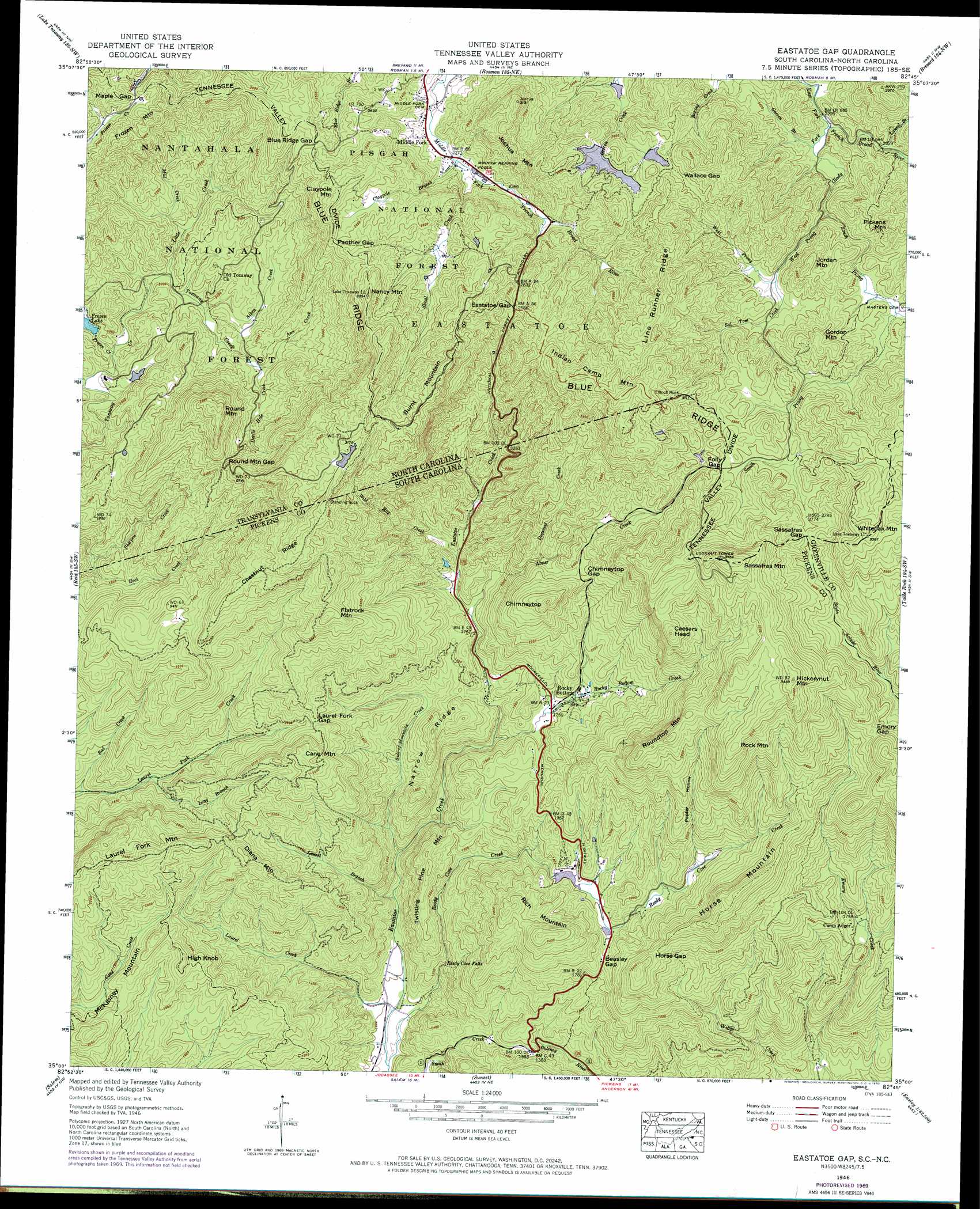
USGS Topo Quad 35082a7 - 1:24,000 scale
| Topo Map Name: | Eastatoe Gap |
| USGS Topo Quad ID: | 35082a7 |
| Print Size: | ca. 21 1/4" wide x 27" high |
| Southeast Coordinates: | 35° N latitude / 82.75° W longitude |
| Map Center Coordinates: | 35.0625° N latitude / 82.8125° W longitude |
| U.S. States: | SC, NC |
| Filename: | o35082a7.jpg |
| Download Map JPG Image: | Eastatoe Gap topo map 1:24,000 scale |
| Map Type: | Topographic |
| Topo Series: | 7.5´ |
| Map Scale: | 1:24,000 |
| Source of Map Images: | United States Geological Survey (USGS) |
| Alternate Map Versions: |
Eastatoe Gap NC 1935 Download PDF Buy paper map Eastatoe Gap NC 1946 Download PDF Buy paper map Eastatoe Gap NC 1946, updated 1965 Download PDF Buy paper map Eastatoe Gap NC 1946, updated 1970 Download PDF Buy paper map Eastatoe Gap NC 1946, updated 1994 Download PDF Buy paper map Eastatoe Gap NC 1947, updated 1947 Download PDF Buy paper map Eastatoe Gap NC 1997, updated 2001 Download PDF Buy paper map Eastatoe Gap NC 2011 Download PDF Buy paper map Eastatoe Gap NC 2013 Download PDF Buy paper map Eastatoe Gap NC 2016 Download PDF Buy paper map |
| FStopo: | US Forest Service topo Eastatoe Gap is available: Download FStopo PDF Download FStopo TIF |
1:24,000 Topo Quads surrounding Eastatoe Gap
Tuckasegee |
Sam Knob |
Shining Rock |
Pisgah Forest |
Horse Shoe |
Big Ridge |
Lake Toxaway |
Rosman |
Brevard |
Standingstone Mountain |
Cashiers |
Reid |
Eastatoe Gap |
Table Rock |
Cleveland |
Tamassee |
Salem |
Sunset |
Pickens |
Dacusville |
Walhalla |
Old Pickens |
Six Mile |
Liberty |
Easley |
> Back to 35082a1 at 1:100,000 scale
> Back to 35082a1 at 1:250,000 scale
> Back to U.S. Topo Maps home
Eastatoe Gap topo map: Gazetteer
Eastatoe Gap: Dams
Frozen Lake Dam elevation 589m 1932′Reedy Cove Creek Lake Dam D-1964 elevation 541m 1774′
The Wilds Dam elevation 580m 1902′
Upper Sagar Dam elevation 843m 2765′
W S Sagar Lake Dam elevation 795m 2608′
Eastatoe Gap: Falls
Reedy Cove Falls elevation 352m 1154′Eastatoe Gap: Gaps
Beasley Gap elevation 575m 1886′Blue Ridge Gap elevation 826m 2709′
Chimneytop Gap elevation 734m 2408′
Eastatoe Gap elevation 833m 2732′
Emory Gap elevation 842m 2762′
Folly Gap elevation 860m 2821′
Horse Gap elevation 714m 2342′
Laurel Fork Gap elevation 636m 2086′
Maple Gap elevation 732m 2401′
Panther Gap elevation 856m 2808′
Round Mountain Gap elevation 781m 2562′
Sassafras Gap elevation 873m 2864′
Wallace Gap elevation 842m 2762′
Eastatoe Gap: Populated Places
Line Runner Ridge elevation 825m 2706′Middle Fork elevation 697m 2286′
Ridge Haven elevation 712m 2335′
Rocky Bottom elevation 532m 1745′
Round Mountain elevation 734m 2408′
Eastatoe Gap: Reservoirs
Frozen Lake elevation 589m 1932′Noname elevation 580m 1902′
Reedy Cove Creek Lake elevation 541m 1774′
W S Sagar Lake elevation 795m 2608′
Eastatoe Gap: Ridges
Chestnut Ridge elevation 915m 3001′Line Runner Ridge elevation 975m 3198′
Narrow Ridge elevation 565m 1853′
Eastatoe Gap: Streams
Abner Creek elevation 537m 1761′Ann Creek elevation 677m 2221′
Bad Creek elevation 425m 1394′
Bearpen Creek elevation 494m 1620′
Claypole Branch elevation 696m 2283′
Devils Hole Creek elevation 644m 2112′
Dogwood Creek elevation 678m 2224′
Dogwood Creek elevation 668m 2191′
Frozen Creek elevation 578m 1896′
Garren Branch elevation 703m 2306′
Glady Fork elevation 700m 2296′
Jane Cantrell Creek elevation 775m 2542′
Laurel Branch elevation 707m 2319′
Laurel Branch elevation 324m 1062′
Laurel Creek elevation 293m 961′
Little Creek elevation 589m 1932′
Long Branch elevation 451m 1479′
Mill Creek elevation 589m 1932′
Reedy Cove Creek elevation 290m 951′
Rocky Bottom Creek elevation 459m 1505′
Sal Tom Creek elevation 769m 2522′
Shoal Creek elevation 696m 2283′
Side-of-Mountain Creek elevation 351m 1151′
South Prong Glady Fork elevation 732m 2401′
West Prong Glady Fork elevation 732m 2401′
Wild Hog Creek elevation 559m 1833′
Wild Hog Creek elevation 555m 1820′
Eastatoe Gap: Summits
Burnt Mountain elevation 1011m 3316′Caesars Head elevation 978m 3208′
Cane Mountain elevation 755m 2477′
Chimneytop elevation 852m 2795′
Claypole Mountain elevation 897m 2942′
Diana Mountain elevation 673m 2208′
Flatrock Mountain elevation 879m 2883′
Frozen Mountain elevation 824m 2703′
Gordon Mountain elevation 900m 2952′
Hickorynut Mountain elevation 1063m 3487′
High Knob elevation 620m 2034′
Horse Mountain elevation 845m 2772′
Indian Camp Mountain elevation 1027m 3369′
Jordan Mountain elevation 880m 2887′
Joshua Mountain elevation 936m 3070′
McKinney Mountain elevation 649m 2129′
Nancy Mountain elevation 981m 3218′
Pickens Mountain elevation 894m 2933′
Rich Mountain elevation 769m 2522′
Rock Mountain elevation 1003m 3290′
Round Mountain elevation 890m 2919′
Roundtop Mountain elevation 929m 3047′
Sassafras Mountain elevation 1081m 3546′
Sassafras Mountain elevation 1087m 3566′
Twisting Pine Mountain elevation 545m 1788′
Whiteoak Mountain elevation 1002m 3287′
Eastatoe Gap: Valleys
Poplar Hollow elevation 600m 1968′Eastatoe Gap digital topo map on disk
Buy this Eastatoe Gap topo map showing relief, roads, GPS coordinates and other geographical features, as a high-resolution digital map file on DVD:
South Carolina, Western North Carolina & Northeastern Georgia
Buy digital topo maps: South Carolina, Western North Carolina & Northeastern Georgia