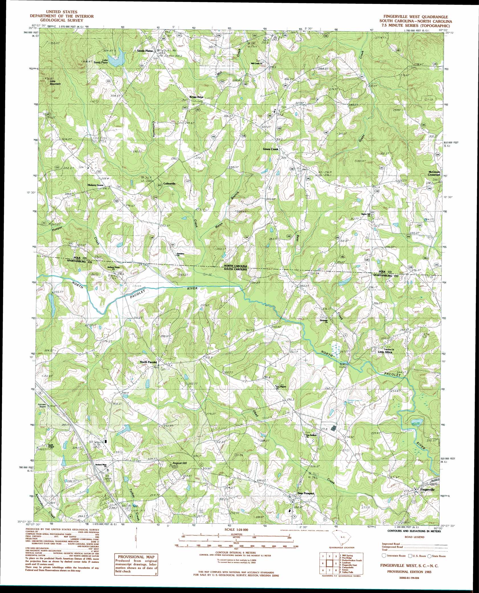
Fingerville West Topo Map South Carolina
To zoom in, hover over the map of Fingerville West
USGS Topo Quad 35082b1 - 1:24,000 scale
| Topo Map Name: | Fingerville West |
| USGS Topo Quad ID: | 35082b1 |
| Print Size: | ca. 21 1/4" wide x 27" high |
| Southeast Coordinates: | 35.125° N latitude / 82° W longitude |
| Map Center Coordinates: | 35.1875° N latitude / 82.0625° W longitude |
| U.S. States: | SC, NC |
| Filename: | o35082b1.jpg |
| Download Map JPG Image: | Fingerville West topo map 1:24,000 scale |
| Map Type: | Topographic |
| Topo Series: | 7.5´ |
| Map Scale: | 1:24,000 |
| Source of Map Images: | United States Geological Survey (USGS) |
| Alternate Map Versions: |
Fingerville West SC 1983, updated 1983 Download PDF Buy paper map Fingerville West SC 2011 Download PDF Buy paper map Fingerville West SC 2014 Download PDF Buy paper map |
1:24,000 Topo Quads surrounding Fingerville West
Bat Cave |
Lake Lure |
Shingle Hollow |
Rutherfordton North |
Sunshine |
Cliffield Mountain |
Mill Spring |
Pea Ridge |
Rutherfordton South |
Forest City |
Saluda |
Landrum |
Fingerville West |
Fingerville East |
Chesnee |
Tigerville |
Campobello |
Inman |
Valley Falls |
Cowpens |
Taylors |
Greer |
Wellford |
Spartanburg |
Pacolet |
> Back to 35082a1 at 1:100,000 scale
> Back to 35082a1 at 1:250,000 scale
> Back to U.S. Topo Maps home
Fingerville West topo map: Gazetteer
Fingerville West: Airports
Fairview Airport elevation 309m 1013′Fingerville West: Bridges
Camps Bridge elevation 238m 780′Carpenter Bridge elevation 244m 800′
Rutledge Bridge elevation 246m 807′
Fingerville West: Crossings
Interchange 5 elevation 309m 1013′Fingerville West: Dams
C Barre Pond Dam D-3301 elevation 301m 987′D Honey Number One Pond Dam D-3302 elevation 280m 918′
D Honey Pond Dam Number Three D-3303 elevation 291m 954′
Sandy Plains Dam elevation 292m 958′
South Carolina Noname 42020 D-1682 Dam elevation 287m 941′
T Steppe Pond Dam D-3299 elevation 281m 921′
Fingerville West: Populated Places
Bryants Store (historical) elevation 275m 902′Collinsville elevation 268m 879′
Fingerville elevation 271m 889′
Green Creek elevation 315m 1033′
Hickory Grove elevation 294m 964′
Kross Keys elevation 312m 1023′
Little Africa elevation 240m 787′
McGinnis Crossroads elevation 301m 987′
New Prospect elevation 281m 921′
North Pacolet elevation 305m 1000′
Obed (historical) elevation 295m 967′
Sandy Plains elevation 309m 1013′
Fingerville West: Reservoirs
C Barre Pond elevation 301m 987′D Honey Incorporated Pond elevation 291m 954′
D Honey Number One Pond elevation 280m 918′
Fairview Farms Pond elevation 287m 941′
Lake Sandy Plains elevation 292m 958′
Steppes Pond elevation 281m 921′
Fingerville West: Streams
Bear Creek elevation 238m 780′Collinsville Creek elevation 244m 800′
Hooper Creek elevation 244m 800′
Hughes Creek elevation 244m 800′
Marys Branch elevation 246m 807′
Fingerville West: Summits
August Hill elevation 347m 1138′Little Mountain elevation 430m 1410′
Fingerville West digital topo map on disk
Buy this Fingerville West topo map showing relief, roads, GPS coordinates and other geographical features, as a high-resolution digital map file on DVD:
South Carolina, Western North Carolina & Northeastern Georgia
Buy digital topo maps: South Carolina, Western North Carolina & Northeastern Georgia