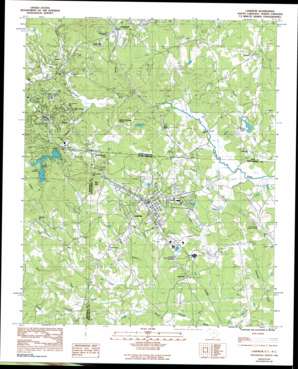
Landrum Topo Map South Carolina
To zoom in, hover over the map of Landrum
USGS Topo Quad 35082b2 - 1:24,000 scale
| Topo Map Name: | Landrum |
| USGS Topo Quad ID: | 35082b2 |
| Print Size: | ca. 21 1/4" wide x 27" high |
| Southeast Coordinates: | 35.125° N latitude / 82.125° W longitude |
| Map Center Coordinates: | 35.1875° N latitude / 82.1875° W longitude |
| U.S. States: | SC, NC |
| Filename: | o35082b2.jpg |
| Download Map JPG Image: | Landrum topo map 1:24,000 scale |
| Map Type: | Topographic |
| Topo Series: | 7.5´ |
| Map Scale: | 1:24,000 |
| Source of Map Images: | United States Geological Survey (USGS) |
| Alternate Map Versions: |
Landrum SC 1968, updated 1992 Download PDF Buy paper map Landrum SC 1983, updated 1983 Download PDF Buy paper map Landrum SC 2011 Download PDF Buy paper map Landrum SC 2014 Download PDF Buy paper map |
1:24,000 Topo Quads surrounding Landrum
> Back to 35082a1 at 1:100,000 scale
> Back to 35082a1 at 1:250,000 scale
> Back to U.S. Topo Maps home
Landrum topo map: Gazetteer
Landrum: Bridges
Earle Bridge elevation 261m 856′Guthrie Bridge elevation 263m 862′
Landrum: Crossings
Interchange 1 elevation 279m 915′Landrum: Dams
C Earley Pond Dam D-3300 elevation 273m 895′Hooper Creek Dam elevation 287m 941′
Johnson Development Number One Pond Dam D-3305 elevation 290m 951′
Johnson Development Pond Number Two Dam D-3304 elevation 297m 974′
Mahlers Pond Dam elevation 294m 964′
South Carolina Noname 23001 Dam elevation 318m 1043′
Landrum: Parks
Harmon Field elevation 294m 964′Landrum: Populated Places
Bennetts elevation 302m 990′Brookwood Trailer Park elevation 293m 961′
Burnt Chimney Corner elevation 343m 1125′
Five Oaks elevation 286m 938′
Ingleside elevation 301m 987′
Lake Lanier elevation 332m 1089′
Landrum elevation 319m 1046′
Lynn elevation 278m 912′
Peniel elevation 357m 1171′
Springdale elevation 279m 915′
Tryon elevation 336m 1102′
Landrum: Reservoirs
C Earley Pond One elevation 273m 895′Hooper Creek Lake elevation 287m 941′
Johnson Development Pond Number Two Dam elevation 297m 974′
Lake Lanier elevation 318m 1043′
Lake Lanier elevation 318m 1043′
Mahler Pond elevation 294m 964′
Landrum: Streams
Belue Creek elevation 274m 898′Clear Branch elevation 273m 895′
Green Creek elevation 287m 941′
Horse Creek elevation 266m 872′
Jamison Mill Creek elevation 263m 862′
Little Creek elevation 312m 1023′
Little Creek elevation 312m 1023′
Page Creek elevation 250m 820′
Skyuka Creek elevation 278m 912′
Spivey Creek elevation 263m 862′
Vaughn Creek elevation 276m 905′
Wolfe Creek elevation 256m 839′
Wolfe Creek elevation 256m 839′
Landrum: Summits
Bird Mountain elevation 452m 1482′Mockingbird Hill elevation 388m 1272′
Landrum digital topo map on disk
Buy this Landrum topo map showing relief, roads, GPS coordinates and other geographical features, as a high-resolution digital map file on DVD:
South Carolina, Western North Carolina & Northeastern Georgia
Buy digital topo maps: South Carolina, Western North Carolina & Northeastern Georgia


