Rosman Topo Map North Carolina
To zoom in, hover over the map of Rosman
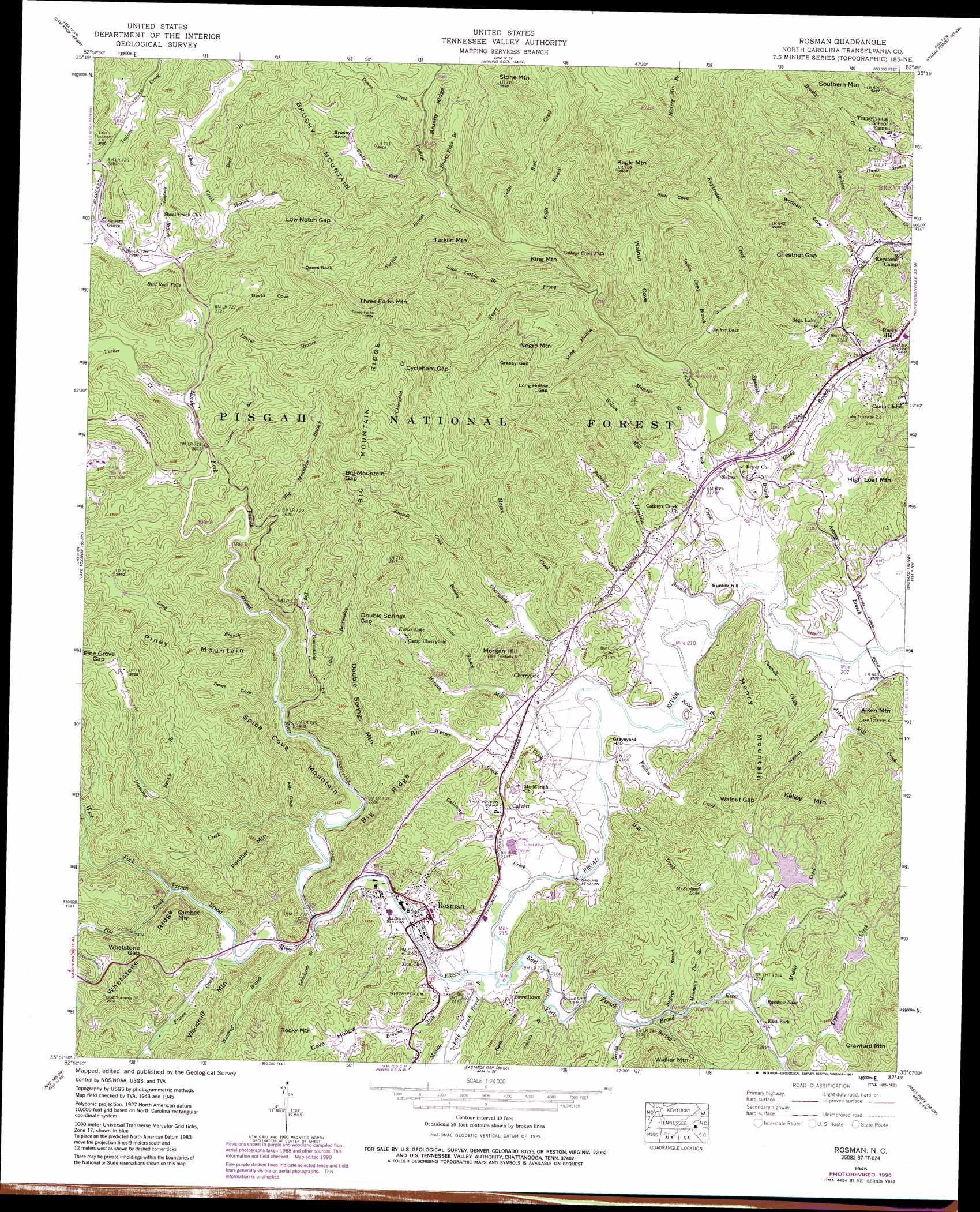
USGS Topo Quad 35082b7 - 1:24,000 scale
| Topo Map Name: | Rosman |
| USGS Topo Quad ID: | 35082b7 |
| Print Size: | ca. 21 1/4" wide x 27" high |
| Southeast Coordinates: | 35.125° N latitude / 82.75° W longitude |
| Map Center Coordinates: | 35.1875° N latitude / 82.8125° W longitude |
| U.S. State: | NC |
| Filename: | o35082b7.jpg |
| Download Map JPG Image: | Rosman topo map 1:24,000 scale |
| Map Type: | Topographic |
| Topo Series: | 7.5´ |
| Map Scale: | 1:24,000 |
| Source of Map Images: | United States Geological Survey (USGS) |
| Alternate Map Versions: |
Rosman NC 1935 Download PDF Buy paper map Rosman NC 1945, updated 1957 Download PDF Buy paper map Rosman NC 1945, updated 1964 Download PDF Buy paper map Rosman NC 1945, updated 1972 Download PDF Buy paper map Rosman NC 1945, updated 1979 Download PDF Buy paper map Rosman NC 1945, updated 1991 Download PDF Buy paper map Rosman NC 1945, updated 1991 Download PDF Buy paper map Rosman NC 1946, updated 1947 Download PDF Buy paper map Rosman NC 1997, updated 2001 Download PDF Buy paper map Rosman NC 2011 Download PDF Buy paper map Rosman NC 2013 Download PDF Buy paper map Rosman NC 2016 Download PDF Buy paper map |
| FStopo: | US Forest Service topo Rosman is available: Download FStopo PDF Download FStopo TIF |
1:24,000 Topo Quads surrounding Rosman
Hazelwood |
Waynesville |
Cruso |
Dunsmore Mountain |
Skyland |
Tuckasegee |
Sam Knob |
Shining Rock |
Pisgah Forest |
Horse Shoe |
Big Ridge |
Lake Toxaway |
Rosman |
Brevard |
Standingstone Mountain |
Cashiers |
Reid |
Eastatoe Gap |
Table Rock |
Cleveland |
Tamassee |
Salem |
Sunset |
Pickens |
Dacusville |
> Back to 35082a1 at 1:100,000 scale
> Back to 35082a1 at 1:250,000 scale
> Back to U.S. Topo Maps home
Rosman topo map: Gazetteer
Rosman: Dams
Deep Woods Dam elevation 756m 2480′Ford Lake Dam elevation 746m 2447′
Lake Wanteska Dam elevation 745m 2444′
Laurel Lake Dam elevation 692m 2270′
Lora Young Dam elevation 727m 2385′
Shearin Dam elevation 736m 2414′
Rosman: Falls
Bird Rock Falls elevation 837m 2746′Catheys Creek Falls elevation 800m 2624′
Rosman: Gaps
Big Mountain Gap elevation 919m 3015′Chestnut Gap elevation 806m 2644′
Cycleham Gap elevation 934m 3064′
Double Springs Gap elevation 883m 2896′
Grassy Gap elevation 970m 3182′
Long Hollow Gap elevation 921m 3021′
Low Notch Gap elevation 1024m 3359′
Pine Grove Gap elevation 865m 2837′
Walnut Gap elevation 788m 2585′
Whetstone Gap elevation 779m 2555′
Rosman: Populated Places
Balsam Grove elevation 862m 2828′Barberry Heights elevation 705m 2312′
Calvert elevation 690m 2263′
Catheys Creek Estates elevation 695m 2280′
Cherryfield elevation 681m 2234′
East Fork elevation 696m 2283′
Illahee Hills elevation 697m 2286′
Laurel Falls elevation 743m 2437′
Piney Woods elevation 711m 2332′
Powelltown elevation 670m 2198′
Rocky Hill elevation 691m 2267′
Rosman elevation 671m 2201′
Sega Lake elevation 688m 2257′
Selica elevation 670m 2198′
Rosman: Reservoirs
Arthur Lake elevation 700m 2296′Brevard Music Center Lake elevation 695m 2280′
Deep Woods Lake elevation 756m 2480′
Ford Lake elevation 746m 2447′
Kaiser Lake elevation 761m 2496′
Lake Wanteska elevation 745m 2444′
Laurel Falls Lake elevation 689m 2260′
Laurel Lake elevation 692m 2270′
Lora Young Lake elevation 727m 2385′
McFarland Lake elevation 738m 2421′
Mitchums Lake elevation 682m 2237′
Rainbow Lake elevation 701m 2299′
Shearin Pond elevation 736m 2414′
Rosman: Ridges
Big Mountain Ridge elevation 979m 3211′Big Ridge elevation 832m 2729′
Brushy Ridge elevation 1002m 3287′
Whetstone Ridge elevation 817m 2680′
Rosman: Streams
Adams Branch elevation 648m 2125′Aiken Mill Creek elevation 650m 2132′
Bart Branch elevation 864m 2834′
Beasley Branch elevation 685m 2247′
Big Bearwallow Creek elevation 699m 2293′
Big Mountain Branch elevation 773m 2536′
Blue Ridge Branch elevation 702m 2303′
Boring Creek elevation 685m 2247′
Brackens Creek elevation 661m 2168′
Browns Mill Creek elevation 663m 2175′
Brushy Ridge Branch elevation 839m 2752′
Buffeys Branch elevation 684m 2244′
Bynum Branch elevation 787m 2582′
Cantrell Creek elevation 652m 2139′
Carson Creek elevation 650m 2132′
Catheys Creek elevation 650m 2132′
Cedar Rock Creek elevation 802m 2631′
Charles Creek elevation 925m 3034′
Cherryfield Creek elevation 654m 2145′
Crow Branch elevation 686m 2250′
Diamond Creek elevation 675m 2214′
Dunns Creek elevation 912m 2992′
East Fork French Broad River elevation 662m 2171′
Flat Creek elevation 701m 2299′
Frozen Creek elevation 679m 2227′
Galloway Creek elevation 662m 2171′
Gaylors Branch elevation 853m 2798′
Gerren Creek elevation 682m 2237′
Glady Branch elevation 659m 2162′
Glady Fork elevation 844m 2769′
Hickory Mountain Branch elevation 902m 2959′
Indian Camp Branch elevation 700m 2296′
Indian Creek elevation 869m 2851′
Jason Branch elevation 796m 2611′
Joshua Branch elevation 667m 2188′
Kagle Branch elevation 799m 2621′
Kelley Branch elevation 654m 2145′
Kuykendall Creek elevation 685m 2247′
Lamance Creek elevation 790m 2591′
Laurel Branch elevation 804m 2637′
Limekiln Branch elevation 653m 2142′
Little Bearwallow Creek elevation 778m 2552′
Little Tarkiln Branch elevation 817m 2680′
Long Branch elevation 720m 2362′
Lower Creek elevation 693m 2273′
Mason Creek elevation 662m 2171′
Matheys Branch elevation 671m 2201′
Middle Creek elevation 694m 2276′
Middle Fork French Broad River elevation 663m 2175′
Mill Creek elevation 657m 2155′
Morgan Mill Creek elevation 654m 2145′
Mountain Tea Branch elevation 693m 2273′
Negro Prong elevation 725m 2378′
North Fork French Broad River elevation 669m 2194′
Patterson Creek elevation 653m 2142′
Paxton Creek elevation 653m 2142′
Peter Weaver Creek elevation 660m 2165′
Sawmill Creek elevation 720m 2362′
Schoolpath Branch elevation 672m 2204′
Shoal Creek elevation 844m 2769′
Spanish Oak Branch elevation 654m 2145′
Tarkiln Branch elevation 835m 2739′
Tucker Creek elevation 799m 2621′
Upper Creek elevation 697m 2286′
West Fork French Broad River elevation 669m 2194′
Wilson Mill Creek elevation 653m 2142′
Woodruff Branch elevation 672m 2204′
Rosman: Summits
Aiken Mountain elevation 808m 2650′Brushy Knob elevation 1041m 3415′
Bunker Hill elevation 688m 2257′
Crawford Mountain elevation 931m 3054′
Daves Rock elevation 1094m 3589′
Double Springs Mountain elevation 898m 2946′
Graveyard Hill elevation 686m 2250′
Henry Mountain elevation 866m 2841′
High Loaf Mountain elevation 786m 2578′
Kagle Mountain elevation 1185m 3887′
Kelley Mountain elevation 911m 2988′
King Mountain elevation 899m 2949′
Morgan Hill elevation 775m 2542′
Negro Mountain elevation 1028m 3372′
Panther Mountain elevation 875m 2870′
Piney Mountain elevation 981m 3218′
Quebec Mountain elevation 886m 2906′
Rocky Mountain elevation 903m 2962′
Southern Mountain elevation 882m 2893′
Spice Cove Mountain elevation 947m 3106′
Stone Mountain elevation 1116m 3661′
Tarkiln Mountain elevation 1081m 3546′
Three Forks Mountain elevation 1144m 3753′
Walker Mountain elevation 861m 2824′
Woodruff Mountain elevation 867m 2844′
Rosman: Valleys
Ash Cove elevation 689m 2260′Cove Hollow elevation 692m 2270′
Daves Cove elevation 805m 2641′
Gads Cove elevation 662m 2171′
Long Hollow elevation 715m 2345′
Rich Cove elevation 780m 2559′
Spice Cove elevation 701m 2299′
Walnut Cove elevation 700m 2296′
Walnut Hollow elevation 662m 2171′
Wolfpen Cove elevation 680m 2230′
Rosman digital topo map on disk
Buy this Rosman topo map showing relief, roads, GPS coordinates and other geographical features, as a high-resolution digital map file on DVD:
South Carolina, Western North Carolina & Northeastern Georgia
Buy digital topo maps: South Carolina, Western North Carolina & Northeastern Georgia