Lake Toxaway Topo Map North Carolina
To zoom in, hover over the map of Lake Toxaway
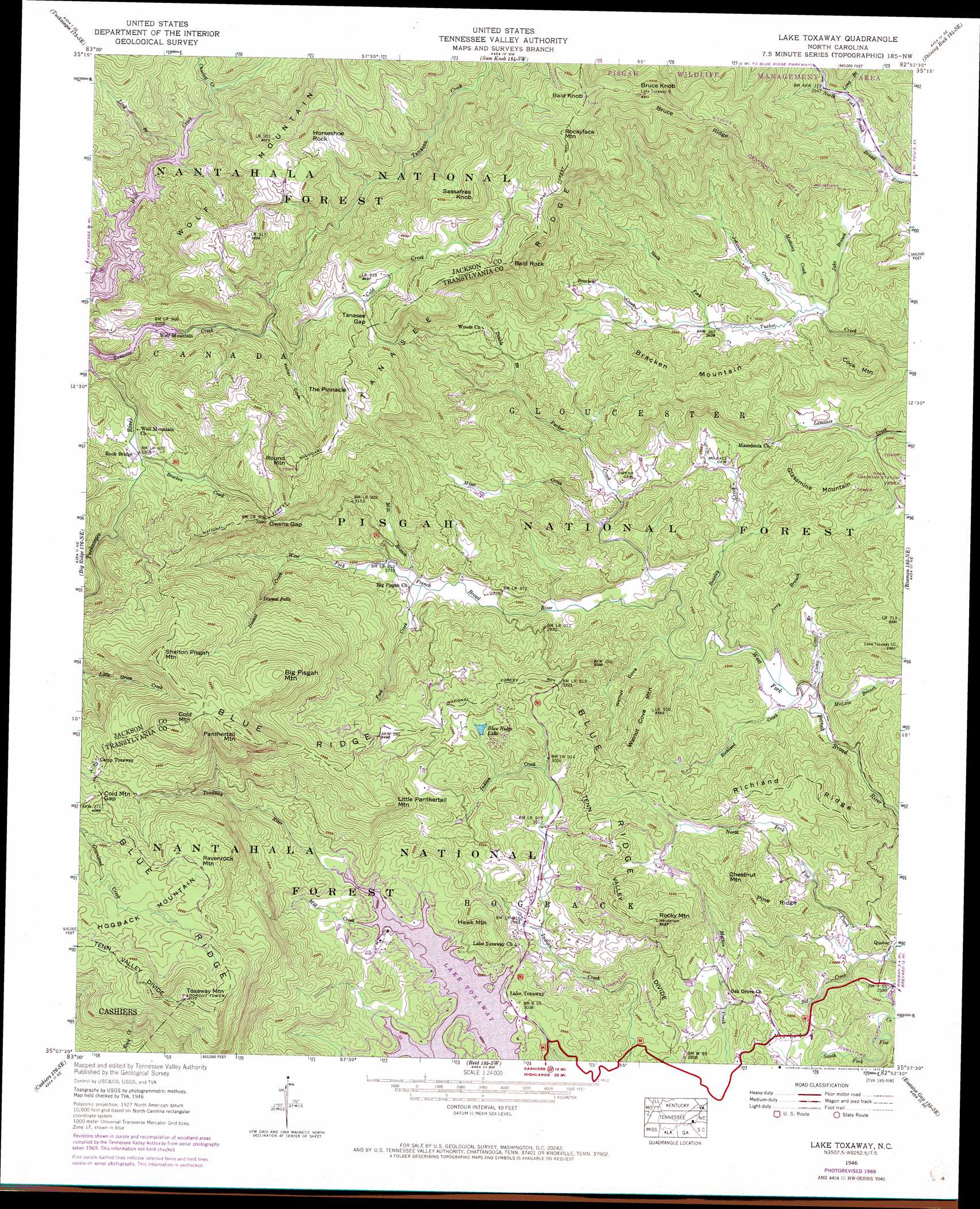
USGS Topo Quad 35082b8 - 1:24,000 scale
| Topo Map Name: | Lake Toxaway |
| USGS Topo Quad ID: | 35082b8 |
| Print Size: | ca. 21 1/4" wide x 27" high |
| Southeast Coordinates: | 35.125° N latitude / 82.875° W longitude |
| Map Center Coordinates: | 35.1875° N latitude / 82.9375° W longitude |
| U.S. State: | NC |
| Filename: | o35082b8.jpg |
| Download Map JPG Image: | Lake Toxaway topo map 1:24,000 scale |
| Map Type: | Topographic |
| Topo Series: | 7.5´ |
| Map Scale: | 1:24,000 |
| Source of Map Images: | United States Geological Survey (USGS) |
| Alternate Map Versions: |
Lake Toxaway NC 1935 Download PDF Buy paper map Lake Toxaway NC 1946, updated 1956 Download PDF Buy paper map Lake Toxaway NC 1946, updated 1965 Download PDF Buy paper map Lake Toxaway NC 1946, updated 1970 Download PDF Buy paper map Lake Toxaway NC 1946, updated 1970 Download PDF Buy paper map Lake Toxaway NC 1947, updated 1947 Download PDF Buy paper map Lake Toxaway NC 1997, updated 2001 Download PDF Buy paper map Lake Toxaway NC 2011 Download PDF Buy paper map Lake Toxaway NC 2013 Download PDF Buy paper map Lake Toxaway NC 2016 Download PDF Buy paper map |
| FStopo: | US Forest Service topo Lake Toxaway is available: Download FStopo PDF Download FStopo TIF |
1:24,000 Topo Quads surrounding Lake Toxaway
Sylva North |
Hazelwood |
Waynesville |
Cruso |
Dunsmore Mountain |
Sylva South |
Tuckasegee |
Sam Knob |
Shining Rock |
Pisgah Forest |
Glenville |
Big Ridge |
Lake Toxaway |
Rosman |
Brevard |
Highlands |
Cashiers |
Reid |
Eastatoe Gap |
Table Rock |
Satolah |
Tamassee |
Salem |
Sunset |
Pickens |
> Back to 35082a1 at 1:100,000 scale
> Back to 35082a1 at 1:250,000 scale
> Back to U.S. Topo Maps home
Lake Toxaway topo map: Gazetteer
Lake Toxaway: Cliffs
Horseshoe Rock elevation 1198m 3930′Lake Toxaway: Dams
Blue Ridge Hills Lake Dam elevation 933m 3061′Indian Lake Upper Dam elevation 958m 3143′
T Fields Dam elevation 935m 3067′
Toxaway Lower Dam elevation 917m 3008′
Upper Lake Toxaway Dam elevation 931m 3054′
Lake Toxaway: Falls
Dismal Falls elevation 963m 3159′Lake Toxaway: Gaps
Cold Mountain Gap elevation 1204m 3950′Owens Gap elevation 1098m 3602′
Tanasee Gap elevation 1092m 3582′
Lake Toxaway: Lakes
Blue Ridge Lake elevation 966m 3169′Lake Toxaway: Populated Places
Canaan elevation 1249m 4097′Fox Ridge elevation 954m 3129′
Indian Lake Estates elevation 974m 3195′
Lake Toxaway elevation 919m 3015′
Quebec elevation 772m 2532′
Wolf Mountain elevation 945m 3100′
Wolf Ridge elevation 993m 3257′
Lake Toxaway: Reservoirs
Blue Ridge Hills Lake elevation 933m 3061′Indian Lake Upper elevation 958m 3143′
Lake Toxaway elevation 917m 3008′
T Fields Lake elevation 935m 3067′
Upper Lake Toxaway elevation 931m 3054′
Lake Toxaway: Ridges
Bruce Ridge elevation 1298m 4258′Pine Ridge elevation 911m 2988′
Richland Ridge elevation 922m 3024′
Tanasee Ridge elevation 1247m 4091′
Lake Toxaway: Streams
Beasley Creek elevation 801m 2627′Bracken Creek elevation 905m 2969′
Bracken Creek elevation 993m 3257′
Camp Cove Branch elevation 787m 2582′
Charley Creek elevation 948m 3110′
Cold Creek elevation 953m 3126′
Deep Ford Creek elevation 917m 3008′
Dismal Creek elevation 862m 2828′
Double Branch elevation 871m 2857′
Fork Creek elevation 824m 2703′
Jake Branch elevation 876m 2874′
Jerry Branch elevation 789m 2588′
Johnies Creek elevation 879m 2883′
Long Branch elevation 935m 3067′
Long Branch elevation 892m 2926′
McLain Branch elevation 786m 2578′
Melhany Creek elevation 877m 2877′
Mill Branch elevation 827m 2713′
Mill Creek elevation 917m 3008′
Miser Creek elevation 827m 2713′
North Fork Flat Creek elevation 770m 2526′
North Fork Tucker Creek elevation 892m 2926′
Parker Creek elevation 799m 2621′
Richland Creek elevation 788m 2585′
Sal Creek elevation 774m 2539′
South Fork Flat Creek elevation 770m 2526′
Tanasee Creek elevation 934m 3064′
Lake Toxaway: Summits
Bald Knob elevation 1452m 4763′Bald Rock elevation 1277m 4189′
Big Pisgah Mountain elevation 1335m 4379′
Bracken Mountain elevation 1076m 3530′
Bruce Knob elevation 1403m 4603′
Chestnut Mountain elevation 1015m 3330′
Cold Mountain elevation 1408m 4619′
Cook Mountain elevation 999m 3277′
Glassmine Mountain elevation 969m 3179′
Hawk Mountain elevation 1015m 3330′
Little Panthertail Mountain elevation 1160m 3805′
Panthertail Mountain elevation 1368m 4488′
Ravenrock Mountain elevation 1324m 4343′
Rocky Mountain elevation 1071m 3513′
Rockyface Mountain elevation 1422m 4665′
Round Mountain elevation 1283m 4209′
Sassafras Knob elevation 1344m 4409′
Shelton Pisgah Mountain elevation 1354m 4442′
The Pinnacle elevation 1261m 4137′
Toxaway Mountain elevation 1455m 4773′
Walnut Cove Mountain elevation 1023m 3356′
Wolf Mountain elevation 1296m 4251′
Lake Toxaway: Valleys
Hogback Valley elevation 917m 3008′Keller Cove elevation 973m 3192′
Walnut Cove elevation 797m 2614′
Lake Toxaway digital topo map on disk
Buy this Lake Toxaway topo map showing relief, roads, GPS coordinates and other geographical features, as a high-resolution digital map file on DVD:
South Carolina, Western North Carolina & Northeastern Georgia
Buy digital topo maps: South Carolina, Western North Carolina & Northeastern Georgia