Hendersonville Topo Map North Carolina
To zoom in, hover over the map of Hendersonville
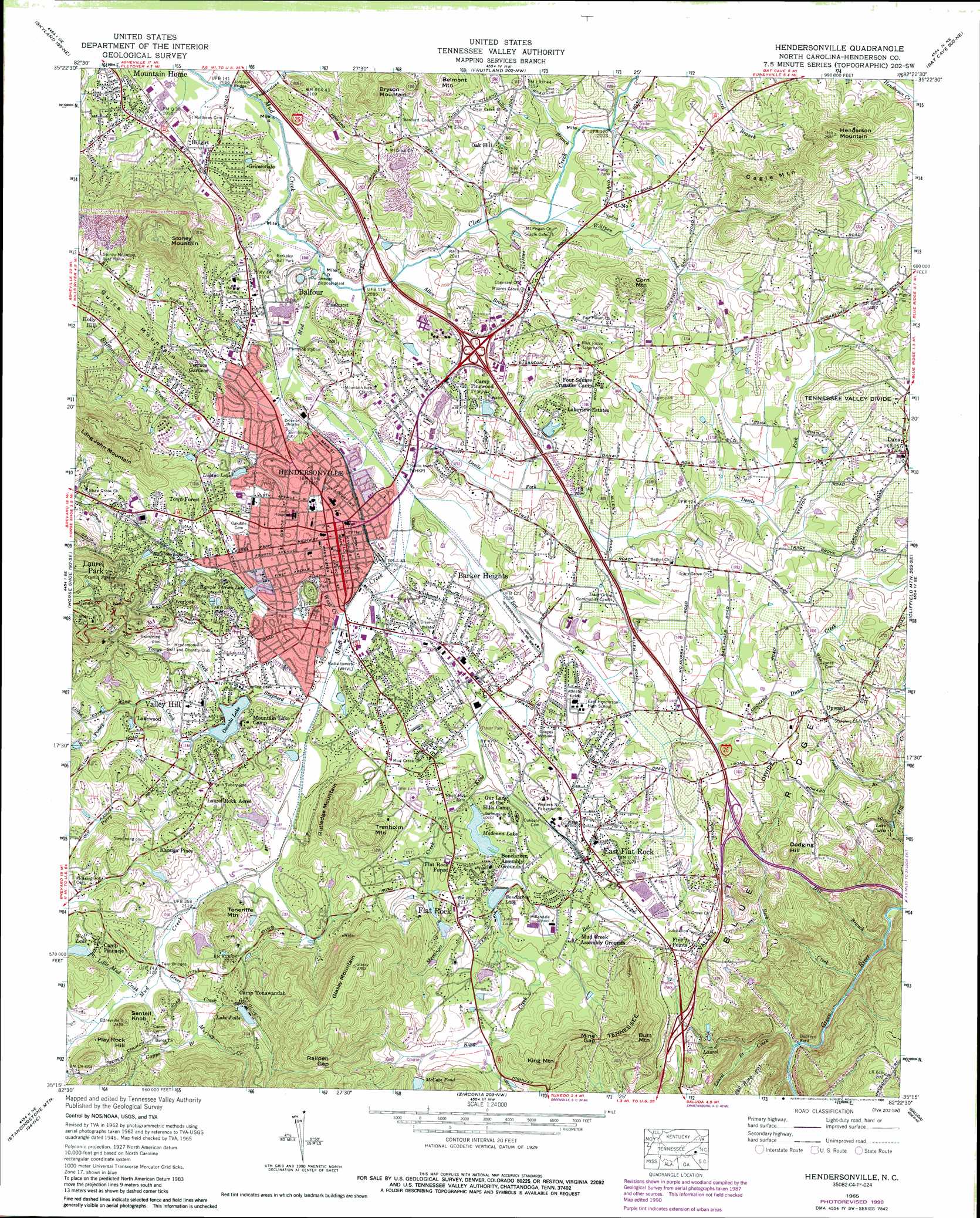
USGS Topo Quad 35082c4 - 1:24,000 scale
| Topo Map Name: | Hendersonville |
| USGS Topo Quad ID: | 35082c4 |
| Print Size: | ca. 21 1/4" wide x 27" high |
| Southeast Coordinates: | 35.25° N latitude / 82.375° W longitude |
| Map Center Coordinates: | 35.3125° N latitude / 82.4375° W longitude |
| U.S. State: | NC |
| Filename: | o35082c4.jpg |
| Download Map JPG Image: | Hendersonville topo map 1:24,000 scale |
| Map Type: | Topographic |
| Topo Series: | 7.5´ |
| Map Scale: | 1:24,000 |
| Source of Map Images: | United States Geological Survey (USGS) |
| Alternate Map Versions: |
Hendersonville NC 1935 Download PDF Buy paper map Hendersonville NC 1946, updated 1957 Download PDF Buy paper map Hendersonville NC 1946, updated 1965 Download PDF Buy paper map Hendersonville NC 1947, updated 1947 Download PDF Buy paper map Hendersonville NC 1947, updated 1947 Download PDF Buy paper map Hendersonville NC 1965, updated 1967 Download PDF Buy paper map Hendersonville NC 1965, updated 1972 Download PDF Buy paper map Hendersonville NC 1965, updated 1979 Download PDF Buy paper map Hendersonville NC 1965, updated 1986 Download PDF Buy paper map Hendersonville NC 1965, updated 1991 Download PDF Buy paper map Hendersonville NC 1965, updated 1991 Download PDF Buy paper map Hendersonville NC 1977, updated 1979 Download PDF Buy paper map Hendersonville NC 1997, updated 2001 Download PDF Buy paper map Hendersonville NC 2010 Download PDF Buy paper map Hendersonville NC 2013 Download PDF Buy paper map Hendersonville NC 2016 Download PDF Buy paper map |
1:24,000 Topo Quads surrounding Hendersonville
Enka |
Asheville |
Oteen |
Black Mountain |
Moffitt Hill |
Dunsmore Mountain |
Skyland |
Fruitland |
Bat Cave |
Lake Lure |
Pisgah Forest |
Horse Shoe |
Hendersonville |
Cliffield Mountain |
Mill Spring |
Brevard |
Standingstone Mountain |
Zirconia |
Saluda |
Landrum |
Table Rock |
Cleveland |
Slater |
Tigerville |
Campobello |
> Back to 35082a1 at 1:100,000 scale
> Back to 35082a1 at 1:250,000 scale
> Back to U.S. Topo Maps home
Hendersonville topo map: Gazetteer
Hendersonville: Airports
Hendersonville-Winkler Airport elevation 635m 2083′Hendersonville: Bridges
Johnson Bridge elevation 629m 2063′Twin Bridges elevation 644m 2112′
Hendersonville: Canals
Johnson Ditch elevation 633m 2076′Hendersonville: Dams
Bonclarken Lake Dam elevation 654m 2145′Crooked Creek Dam elevation 640m 2099′
Front Lake Dam elevation 676m 2217′
Kenmure Pond Dam elevation 673m 2208′
Laurel Park Lake Dam elevation 678m 2224′
Osceola Lake Dam elevation 646m 2119′
Rhett Mill Dam elevation 646m 2119′
Side Lake Dam elevation 676m 2217′
Ton-A-Wanda Dam elevation 683m 2240′
Wolf Lake Dam elevation 650m 2132′
Hendersonville: Gaps
Mine Gap elevation 735m 2411′Railpen Gap elevation 796m 2611′
Hendersonville: Parks
Berkeley Ball Park elevation 644m 2112′Carl Sandburg Home National Historic Site elevation 700m 2296′
Park elevation 648m 2125′
Hendersonville: Populated Places
Balfour elevation 646m 2119′Barker Heights elevation 647m 2122′
Beaumont elevation 680m 2230′
Bent Tree elevation 718m 2355′
Brookdale elevation 644m 2112′
Brookland Manor elevation 655m 2148′
Buckeye Ford elevation 517m 1696′
Butt Mountain elevation 677m 2221′
Camarian Estates elevation 668m 2191′
Cannon Woods elevation 642m 2106′
Carolina Village elevation 663m 2175′
Chanteloupe Country Estates elevation 654m 2145′
Cinnimon Woods elevation 723m 2372′
Claremont elevation 678m 2224′
Country Acres elevation 644m 2112′
Country Club Estates elevation 706m 2316′
Crooked Creek elevation 658m 2158′
Cross William MHP elevation 653m 2142′
Cumberland Village elevation 660m 2165′
Dana elevation 686m 2250′
Dellwood elevation 690m 2263′
Druid Hills elevation 649m 2129′
East Flat Rock elevation 673m 2208′
Echo Acres elevation 725m 2378′
Echo Lakes elevation 690m 2263′
English Hills elevation 658m 2158′
Essex elevation 672m 2204′
Five Points elevation 662m 2171′
Flat Rock elevation 672m 2204′
Flat Rock Forest elevation 667m 2188′
Glenn Brook elevation 671m 2201′
Grimesdale elevation 649m 2129′
Hendersonville elevation 658m 2158′
Hickory Hill elevation 650m 2132′
Highland Hills elevation 668m 2191′
Hillandale elevation 679m 2227′
Hillgirt elevation 648m 2125′
Holly Hill elevation 686m 2250′
Indian Hills elevation 699m 2293′
Kanuga Pines elevation 672m 2204′
Kenwood Knolls elevation 653m 2142′
Kingswood elevation 674m 2211′
Lakeview Estates elevation 656m 2152′
Lakewood elevation 670m 2198′
Laurel Park elevation 722m 2368′
Laurel Park Villas elevation 670m 2198′
Laurel Rock Acres elevation 677m 2221′
Mountain Home elevation 649m 2129′
Mountain Lake Camp elevation 663m 2175′
Oak Hill elevation 664m 2178′
Overlook elevation 695m 2280′
Patton Park elevation 642m 2106′
Pebble Creek elevation 642m 2106′
Pinehurst elevation 653m 2142′
Plantation Walk elevation 642m 2106′
Quail Ridge elevation 690m 2263′
Ravenwood elevation 677m 2221′
Ridgeview Estates elevation 666m 2185′
Rosebud elevation 656m 2152′
Stone Brook elevation 666m 2185′
Stoney Mountain Estate elevation 700m 2296′
Stoneycrest elevation 656m 2152′
Teneriffe elevation 651m 2135′
Terrace Gardens elevation 657m 2155′
The Meadows elevation 639m 2096′
The Pines elevation 665m 2181′
Timberland elevation 670m 2198′
Town Forest elevation 676m 2217′
Tranquility elevation 667m 2188′
U-No elevation 655m 2148′
Upward elevation 660m 2165′
Valley Hill elevation 665m 2181′
Westwood elevation 665m 2181′
Willow Bend elevation 665m 2181′
Willow Brook elevation 658m 2158′
Willow Wew elevation 657m 2155′
Windor Hills elevation 661m 2168′
Woodhaven elevation 689m 2260′
Woodland Trace elevation 661m 2168′
Hendersonville: Post Offices
Mountain Home Post Office (historical) elevation 649m 2129′Hendersonville: Reservoirs
Bonclarken Lake elevation 656m 2152′Crooked Creek Lake elevation 640m 2099′
Front Lake elevation 676m 2217′
Jordans Lake elevation 658m 2158′
Kenmure Pond elevation 673m 2208′
Lake Bonclarken elevation 654m 2145′
Lake Curtis elevation 600m 1968′
Lake Falls elevation 687m 2253′
Laurel Park Lake elevation 678m 2224′
Lugana Lake elevation 647m 2122′
Madonna Lake elevation 646m 2119′
McCabe Pond elevation 707m 2319′
Osceola Lake elevation 646m 2119′
Rainbow Lake elevation 673m 2208′
Side Lake elevation 676m 2217′
Temple Terrace Lake elevation 649m 2129′
Ton-A-Wanda Lake elevation 683m 2240′
Wolf Lake elevation 650m 2132′
Hendersonville: Springs
Crystal Spring elevation 711m 2332′Hendersonville: Streams
Allen Branch elevation 633m 2076′Bat Fork elevation 634m 2080′
Beck Creek elevation 501m 1643′
Brittain Creek elevation 630m 2066′
Capps Branch elevation 652m 2139′
Cherry Branch elevation 631m 2070′
Clear Creek elevation 631m 2070′
Devils Fork elevation 635m 2083′
Dunn Creek elevation 637m 2089′
Featherstone Creek elevation 627m 2057′
Finley Creek elevation 648m 2125′
Greer Creek elevation 645m 2116′
Hill Branch elevation 496m 1627′
Jones Branch elevation 617m 2024′
King Creek elevation 634m 2080′
Laurel Branch elevation 586m 1922′
Laurel Creek elevation 520m 1706′
Little Mud Creek elevation 645m 2116′
Meminger Creek elevation 642m 2106′
Murray Creek elevation 647m 2122′
Perry Creek elevation 647m 2122′
Phillips Branch elevation 637m 2089′
Shepherd Creek elevation 636m 2086′
Tonys Creek elevation 647m 2122′
Wash Creek elevation 636m 2086′
Wolfpen Creek elevation 636m 2086′
Hendersonville: Summits
Butt Mountain elevation 811m 2660′Cagle Mountain elevation 754m 2473′
Dodging Hill elevation 689m 2260′
Glassy Mountain elevation 848m 2782′
Guice Mountain elevation 714m 2342′
Henderson Mountain elevation 778m 2552′
King Mountain elevation 798m 2618′
Long John Mountain elevation 822m 2696′
Play Rock Hill elevation 718m 2355′
Rutledge Mountain elevation 762m 2500′
Sentell Knob elevation 738m 2421′
Stoney Mountain elevation 851m 2791′
Teneriffe Mountain elevation 751m 2463′
Hendersonville digital topo map on disk
Buy this Hendersonville topo map showing relief, roads, GPS coordinates and other geographical features, as a high-resolution digital map file on DVD:
South Carolina, Western North Carolina & Northeastern Georgia
Buy digital topo maps: South Carolina, Western North Carolina & Northeastern Georgia