Shingle Hollow Topo Map North Carolina
To zoom in, hover over the map of Shingle Hollow
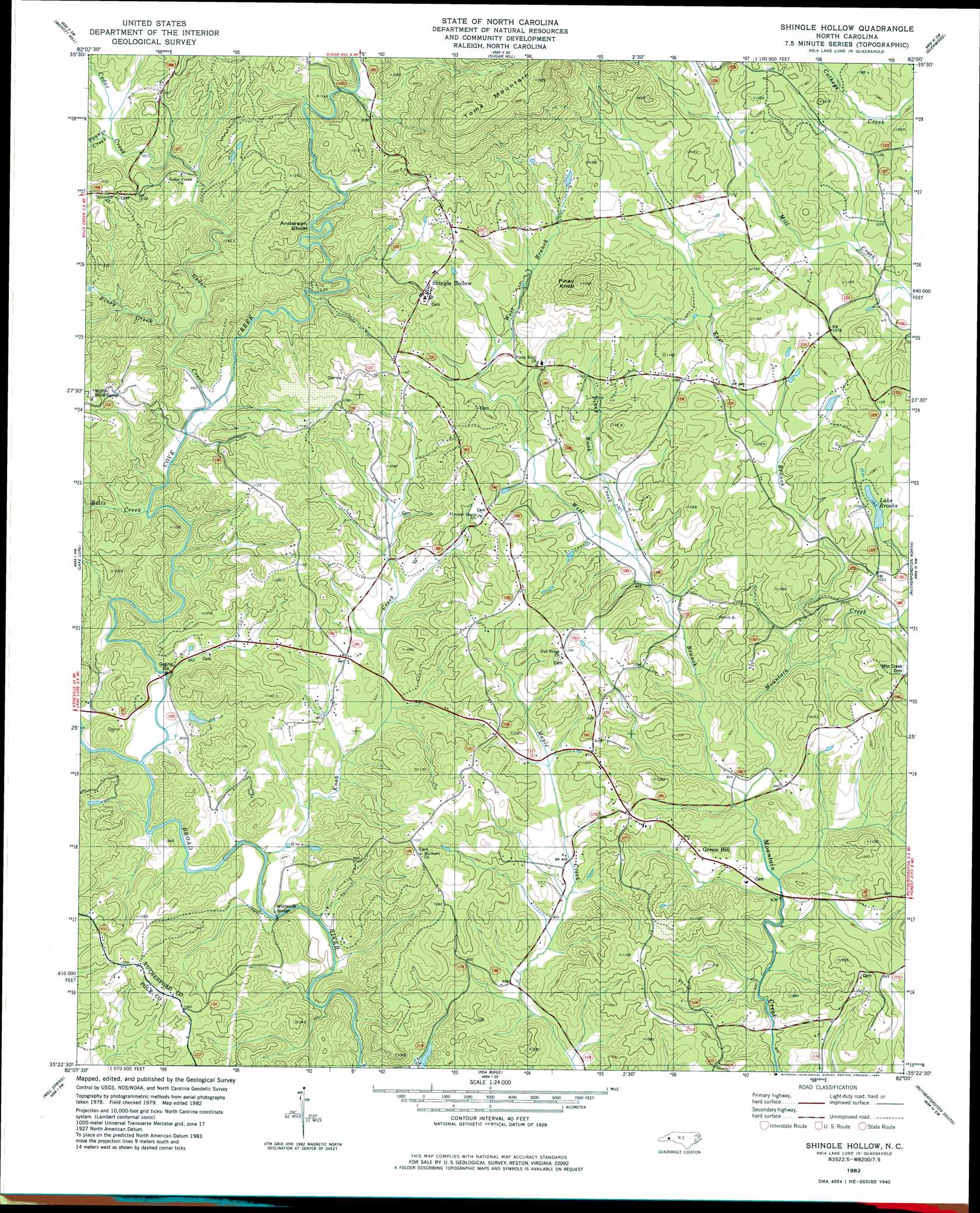
USGS Topo Quad 35082d1 - 1:24,000 scale
| Topo Map Name: | Shingle Hollow |
| USGS Topo Quad ID: | 35082d1 |
| Print Size: | ca. 21 1/4" wide x 27" high |
| Southeast Coordinates: | 35.375° N latitude / 82° W longitude |
| Map Center Coordinates: | 35.4375° N latitude / 82.0625° W longitude |
| U.S. State: | NC |
| Filename: | o35082d1.jpg |
| Download Map JPG Image: | Shingle Hollow topo map 1:24,000 scale |
| Map Type: | Topographic |
| Topo Series: | 7.5´ |
| Map Scale: | 1:24,000 |
| Source of Map Images: | United States Geological Survey (USGS) |
| Alternate Map Versions: |
Shingle Hollow NC 1982, updated 1983 Download PDF Buy paper map Shingle Hollow NC 2010 Download PDF Buy paper map Shingle Hollow NC 2013 Download PDF Buy paper map Shingle Hollow NC 2016 Download PDF Buy paper map |
1:24,000 Topo Quads surrounding Shingle Hollow
Montreat |
Old Fort |
Marion West |
Marion East |
Glen Alpine |
Black Mountain |
Moffitt Hill |
Sugar Hill |
Glenwood |
Dysartsville |
Bat Cave |
Lake Lure |
Shingle Hollow |
Rutherfordton North |
Sunshine |
Cliffield Mountain |
Mill Spring |
Pea Ridge |
Rutherfordton South |
Forest City |
Saluda |
Landrum |
Fingerville West |
Fingerville East |
Chesnee |
> Back to 35082a1 at 1:100,000 scale
> Back to 35082a1 at 1:250,000 scale
> Back to U.S. Topo Maps home
Shingle Hollow topo map: Gazetteer
Shingle Hollow: Bars
Anderson Shoal elevation 298m 977′Shingle Hollow: Bridges
Whiteside Bridge elevation 242m 793′Shingle Hollow: Dams
Brooks Lake Dam elevation 310m 1017′Shingle Hollow: Populated Places
Cuba (historical) elevation 306m 1003′Gage (historical) elevation 378m 1240′
Green Hill elevation 297m 974′
Nanito (historical) elevation 341m 1118′
Nanney (historical) elevation 284m 931′
Shingle Hollow elevation 364m 1194′
Shingle Hollow: Reservoirs
Lake Brooks elevation 306m 1003′Shingle Hollow: Streams
Bills Creek elevation 260m 853′Cedar Creek elevation 266m 872′
Cove Creek elevation 255m 836′
East Branch Mountain Creek elevation 255m 836′
Knob Creek elevation 242m 793′
Piney Creek elevation 272m 892′
Piney Knob Creek elevation 267m 875′
West Branch Mountain Creek elevation 248m 813′
Youngs Creek elevation 319m 1046′
Shingle Hollow: Summits
Piney Knob elevation 466m 1528′Toms Mountain elevation 595m 1952′
Shingle Hollow digital topo map on disk
Buy this Shingle Hollow topo map showing relief, roads, GPS coordinates and other geographical features, as a high-resolution digital map file on DVD:
South Carolina, Western North Carolina & Northeastern Georgia
Buy digital topo maps: South Carolina, Western North Carolina & Northeastern Georgia