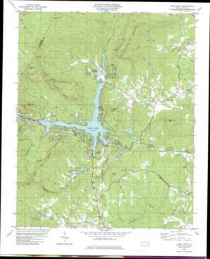
Lake Lure Topo Map North Carolina
To zoom in, hover over the map of Lake Lure
USGS Topo Quad 35082d2 - 1:24,000 scale
| Topo Map Name: | Lake Lure |
| USGS Topo Quad ID: | 35082d2 |
| Print Size: | ca. 21 1/4" wide x 27" high |
| Southeast Coordinates: | 35.375° N latitude / 82.125° W longitude |
| Map Center Coordinates: | 35.4375° N latitude / 82.1875° W longitude |
| U.S. State: | NC |
| Filename: | o35082d2.jpg |
| Download Map JPG Image: | Lake Lure topo map 1:24,000 scale |
| Map Type: | Topographic |
| Topo Series: | 7.5´ |
| Map Scale: | 1:24,000 |
| Source of Map Images: | United States Geological Survey (USGS) |
| Alternate Map Versions: |
Lake Lure NC 1982, updated 1983 Download PDF Buy paper map Lake Lure NC 1982, updated 1992 Download PDF Buy paper map Lake Lure NC 1982, updated 1992 Download PDF Buy paper map Lake Lure NC 2010 Download PDF Buy paper map Lake Lure NC 2013 Download PDF Buy paper map Lake Lure NC 2016 Download PDF Buy paper map |
1:24,000 Topo Quads surrounding Lake Lure
> Back to 35082a1 at 1:100,000 scale
> Back to 35082a1 at 1:250,000 scale
> Back to U.S. Topo Maps home
Lake Lure topo map: Gazetteer
Lake Lure: Crossings
Whiteside Ford elevation 250m 820′Lake Lure: Dams
Bald Mountain Lake Dam elevation 320m 1049′Hickory Nut Lower Dam elevation 292m 958′
Hickory Nut Upper Dam elevation 279m 915′
Lake Lure Dam elevation 272m 892′
Occoneechee Lake Dam elevation 341m 1118′
The Mountains Dam elevation 353m 1158′
Lake Lure: Gaps
Hickorynut Gap elevation 301m 987′Judes Gap elevation 762m 2500′
Lake Lure: Lakes
The Pools elevation 334m 1095′Lake Lure: Populated Places
Bills Creek elevation 343m 1125′Bob (historical) elevation 359m 1177′
Camp Occoneechee elevation 357m 1171′
Carolina Mountains elevation 372m 1220′
Chimney Rock elevation 333m 1092′
Deerfield elevation 390m 1279′
Fairfield Mountains elevation 322m 1056′
Golf Estates elevation 385m 1263′
Lake Lure elevation 337m 1105′
Poplar Grove elevation 287m 941′
Quail Ridge elevation 351m 1151′
Riverbend elevation 287m 941′
Rock Springs elevation 352m 1154′
Uree elevation 271m 889′
Youngs Mountain elevation 418m 1371′
Lake Lure: Reservoirs
Bald Mountain Lake elevation 320m 1049′Hickory Nut Lower Lake elevation 292m 958′
Hickory Nut Upper Lake elevation 279m 915′
Lake Lure elevation 272m 892′
Occoneechee Lake elevation 341m 1118′
The Mountains Lake elevation 353m 1158′
Lake Lure: Streams
Buffalo Creek elevation 302m 990′Cane Creek elevation 318m 1043′
Island Creek elevation 266m 872′
Pool Creek elevation 303m 994′
Wolf Creek elevation 344m 1128′
Lake Lure: Summits
Bills Mountain elevation 557m 1827′Buzzards Roost elevation 448m 1469′
Cane Creek Mountain elevation 843m 2765′
Fairfield Mountain elevation 396m 1299′
Grassy Knob elevation 430m 1410′
Round Top Mountain elevation 804m 2637′
Rumbling Bald Mountain elevation 907m 2975′
Shumont Mountain elevation 1163m 3815′
Weed Patch Mountain elevation 1041m 3415′
Youngs Mountain elevation 812m 2664′
Lake Lure digital topo map on disk
Buy this Lake Lure topo map showing relief, roads, GPS coordinates and other geographical features, as a high-resolution digital map file on DVD:
South Carolina, Western North Carolina & Northeastern Georgia
Buy digital topo maps: South Carolina, Western North Carolina & Northeastern Georgia


