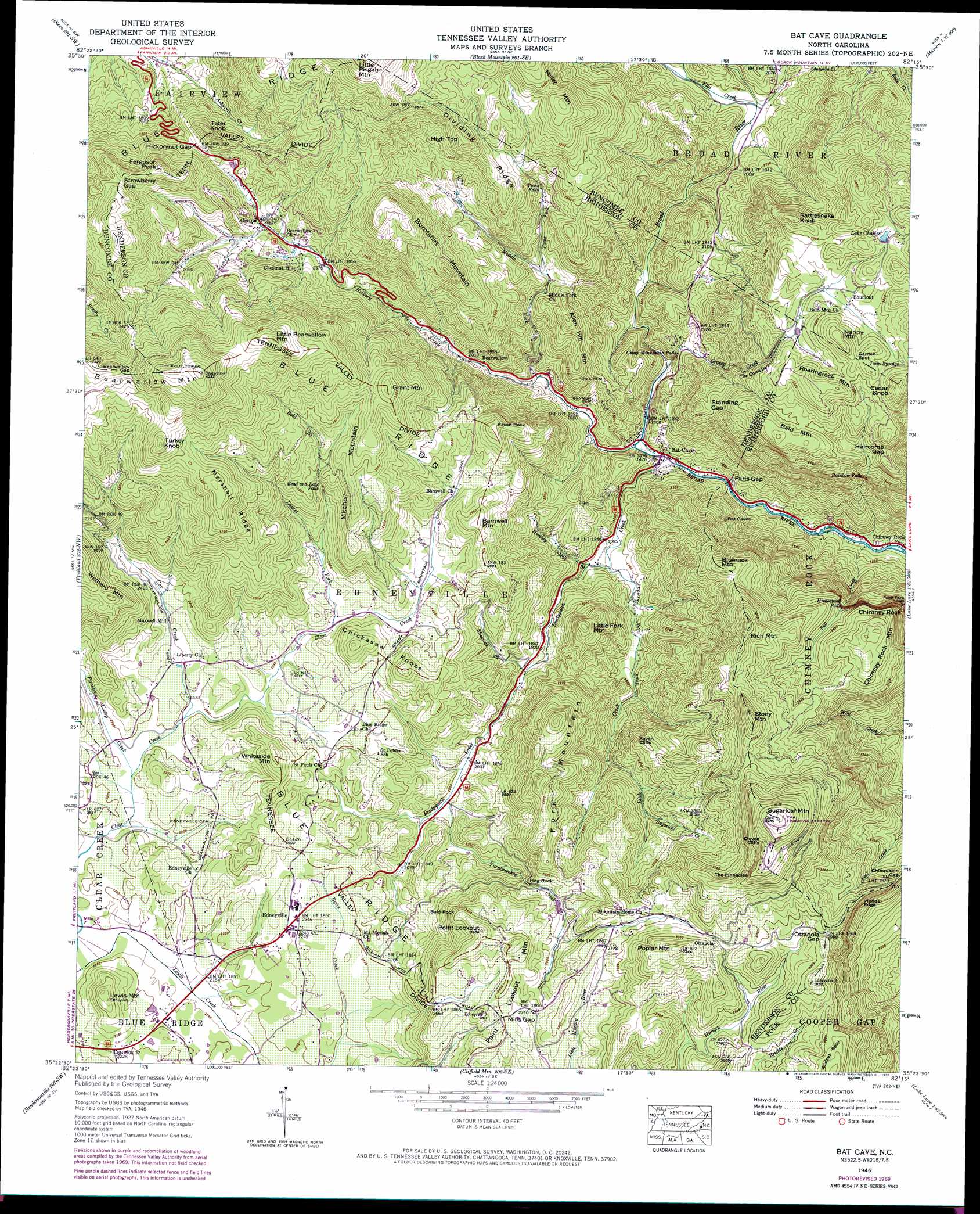
Bat Cave Topo Map North Carolina
To zoom in, hover over the map of Bat Cave
USGS Topo Quad 35082d3 - 1:24,000 scale
| Topo Map Name: | Bat Cave |
| USGS Topo Quad ID: | 35082d3 |
| Print Size: | ca. 21 1/4" wide x 27" high |
| Southeast Coordinates: | 35.375° N latitude / 82.25° W longitude |
| Map Center Coordinates: | 35.4375° N latitude / 82.3125° W longitude |
| U.S. State: | NC |
| Filename: | o35082d3.jpg |
| Download Map JPG Image: | Bat Cave topo map 1:24,000 scale |
| Map Type: | Topographic |
| Topo Series: | 7.5´ |
| Map Scale: | 1:24,000 |
| Source of Map Images: | United States Geological Survey (USGS) |
| Alternate Map Versions: |
Batcave NC 1935 Download PDF Buy paper map Bat Cave NC 1946, updated 1957 Download PDF Buy paper map Bat Cave NC 1946, updated 1965 Download PDF Buy paper map Bat Cave NC 1946, updated 1970 Download PDF Buy paper map Bat Cave NC 1946, updated 1975 Download PDF Buy paper map Bat Cave NC 1946, updated 1991 Download PDF Buy paper map Bat Cave NC 1946, updated 1991 Download PDF Buy paper map Bat Cave NC 1947, updated 1947 Download PDF Buy paper map Bat Cave NC 1947, updated 1947 Download PDF Buy paper map Bat Cave NC 1997, updated 2001 Download PDF Buy paper map Bat Cave NC 2010 Download PDF Buy paper map Bat Cave NC 2013 Download PDF Buy paper map Bat Cave NC 2016 Download PDF Buy paper map |
1:24,000 Topo Quads surrounding Bat Cave
Weaverville |
Craggy Pinnacle |
Montreat |
Old Fort |
Marion West |
Asheville |
Oteen |
Black Mountain |
Moffitt Hill |
Sugar Hill |
Skyland |
Fruitland |
Bat Cave |
Lake Lure |
Shingle Hollow |
Horse Shoe |
Hendersonville |
Cliffield Mountain |
Mill Spring |
Pea Ridge |
Standingstone Mountain |
Zirconia |
Saluda |
Landrum |
Fingerville West |
> Back to 35082a1 at 1:100,000 scale
> Back to 35082a1 at 1:250,000 scale
> Back to U.S. Topo Maps home
Bat Cave topo map: Gazetteer
Bat Cave: Cliffs
Cloven Cliffs elevation 1117m 3664′Raven Cliffs elevation 714m 2342′
The Pinnacles elevation 1074m 3523′
Worlds Edge elevation 781m 2562′
Bat Cave: Dams
Runaway Farm Lake Dam elevation 662m 2171′Bat Cave: Falls
Bead and Lace Falls elevation 803m 2634′Camp Minnehaha Falls elevation 515m 1689′
Hickorynut Falls elevation 740m 2427′
Rainbow Falls elevation 730m 2395′
The Cascades elevation 777m 2549′
Toms Falls elevation 779m 2555′
Bat Cave: Gaps
Bearwallow Gap elevation 1110m 3641′Chinquapin Gap elevation 802m 2631′
Garden Spot elevation 939m 3080′
Haircomb Gap elevation 863m 2831′
Hickorynut Gap elevation 881m 2890′
Mills Gap elevation 836m 2742′
Ottanola Gap elevation 913m 2995′
Paris Gap elevation 430m 1410′
Standing Gap elevation 732m 2401′
Strawberry Gap elevation 1053m 3454′
Bat Cave: Parks
Chimney Rock Park elevation 698m 2290′Bat Cave: Pillars
Chimney Rock elevation 675m 2214′Hog Rock elevation 711m 2332′
Bat Cave: Populated Places
Bat Cave elevation 451m 1479′Bearwallow elevation 619m 2030′
Chestnut Hill elevation 819m 2687′
Esmeralda (historical) elevation 381m 1250′
Gerton elevation 814m 2670′
Maxwell Mill elevation 701m 2299′
Ottanola elevation 895m 2936′
Shumont elevation 889m 2916′
Bat Cave: Reservoirs
Lake Charles elevation 929m 3047′Runaway Farm Lake elevation 662m 2171′
Bat Cave: Ridges
Dividing Ridge elevation 985m 3231′Marshall Ridge elevation 1045m 3428′
Bat Cave: Springs
Twin Springs elevation 918m 3011′Bat Cave: Streams
Bold Branch elevation 729m 2391′Coon Branch elevation 657m 2155′
Cox Creek elevation 665m 2181′
Fall Creek elevation 341m 1118′
Flat Creek elevation 591m 1938′
Grassy Creek elevation 480m 1574′
Hickory Creek elevation 450m 1476′
Hominy Mill Branch elevation 482m 1581′
Laurel Fork elevation 693m 2273′
Little Creek elevation 477m 1564′
Middle Fork Hickory Creek elevation 528m 1732′
Puncheon Camp Creek elevation 661m 2168′
Reedypatch Creek elevation 442m 1450′
Slickrock Branch elevation 557m 1827′
Sugarloaf Creek elevation 716m 2349′
Toms Fork elevation 672m 2204′
Turnbreeches Creek elevation 607m 1991′
Bat Cave: Summits
Allen Hill Mountain elevation 790m 2591′Bald Mountain elevation 924m 3031′
Bald Rock elevation 878m 2880′
Barnwell Mountain elevation 818m 2683′
Bearwallow Mountain elevation 1288m 4225′
Bluerock Mountain elevation 864m 2834′
Burntshirt Mountain elevation 1067m 3500′
Cedar Knob elevation 1016m 3333′
Chickasaw Knobs elevation 807m 2647′
Chimney Rock Mountain elevation 634m 2080′
Edneyville elevation 684m 2244′
Ferguson Peak elevation 1091m 3579′
Fork Mountain elevation 905m 2969′
Grant Mountain elevation 996m 3267′
High Top elevation 1053m 3454′
Lewis Mountain elevation 765m 2509′
Little Bearwallow Mountain elevation 1204m 3950′
Little Fork Mountain elevation 752m 2467′
Miller Mountain elevation 1092m 3582′
Mitchell Mountain elevation 952m 3123′
Nanny Mountain elevation 992m 3254′
Point Lookout elevation 904m 2965′
Point Lookout Mountain elevation 906m 2972′
Poplar Mountain elevation 986m 3234′
Rattlesnake Knob elevation 979m 3211′
Raven Rock elevation 868m 2847′
Rich Mountain elevation 989m 3244′
Roaringrock Mountain elevation 972m 3188′
Stony Mountain elevation 1036m 3398′
Sugarloaf Mountain elevation 1209m 3966′
Tater Knob elevation 1003m 3290′
Turkey Knob elevation 1140m 3740′
Whiteside Mountain elevation 796m 2611′
Bat Cave digital topo map on disk
Buy this Bat Cave topo map showing relief, roads, GPS coordinates and other geographical features, as a high-resolution digital map file on DVD:
South Carolina, Western North Carolina & Northeastern Georgia
Buy digital topo maps: South Carolina, Western North Carolina & Northeastern Georgia