Moffitt Hill Topo Map North Carolina
To zoom in, hover over the map of Moffitt Hill
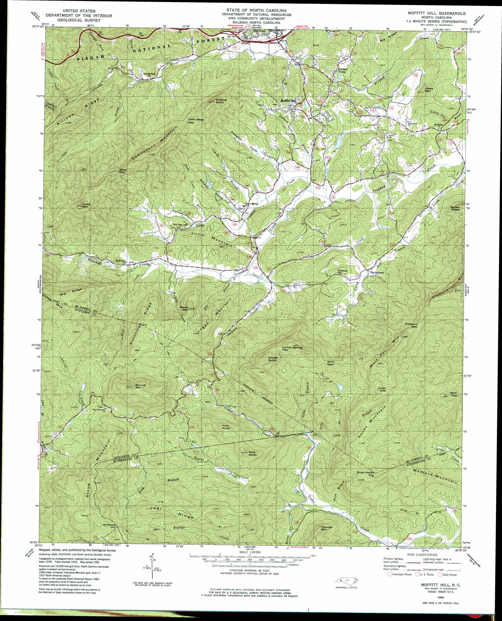
USGS Topo Quad 35082e2 - 1:24,000 scale
| Topo Map Name: | Moffitt Hill |
| USGS Topo Quad ID: | 35082e2 |
| Print Size: | ca. 21 1/4" wide x 27" high |
| Southeast Coordinates: | 35.5° N latitude / 82.125° W longitude |
| Map Center Coordinates: | 35.5625° N latitude / 82.1875° W longitude |
| U.S. State: | NC |
| Filename: | o35082e2.jpg |
| Download Map JPG Image: | Moffitt Hill topo map 1:24,000 scale |
| Map Type: | Topographic |
| Topo Series: | 7.5´ |
| Map Scale: | 1:24,000 |
| Source of Map Images: | United States Geological Survey (USGS) |
| Alternate Map Versions: |
Moffitt Hill NC 1982, updated 1983 Download PDF Buy paper map Moffitt Hill NC 1982, updated 1983 Download PDF Buy paper map Moffitt Hill NC 1994, updated 1998 Download PDF Buy paper map Moffitt Hill NC 2011 Download PDF Buy paper map Moffitt Hill NC 2013 Download PDF Buy paper map Moffitt Hill NC 2016 Download PDF Buy paper map |
| FStopo: | US Forest Service topo Moffitt Hill is available: Download FStopo PDF Download FStopo TIF |
1:24,000 Topo Quads surrounding Moffitt Hill
Barnardsville |
Mount Mitchell |
Celo |
Little Switzerland |
Ashford |
Craggy Pinnacle |
Montreat |
Old Fort |
Marion West |
Marion East |
Oteen |
Black Mountain |
Moffitt Hill |
Sugar Hill |
Glenwood |
Fruitland |
Bat Cave |
Lake Lure |
Shingle Hollow |
Rutherfordton North |
Hendersonville |
Cliffield Mountain |
Mill Spring |
Pea Ridge |
Rutherfordton South |
> Back to 35082e1 at 1:100,000 scale
> Back to 35082a1 at 1:250,000 scale
> Back to U.S. Topo Maps home
Moffitt Hill topo map: Gazetteer
Moffitt Hill: Gaps
Bear Gap elevation 604m 1981′Coon Gap elevation 805m 2641′
England Gap elevation 761m 2496′
Little Deep Gap elevation 623m 2043′
Locust Spring Gap elevation 803m 2634′
Sally Gap elevation 744m 2440′
Sank Gap elevation 717m 2352′
Moffitt Hill: Populated Places
Davistown elevation 480m 1574′Jeter (historical) elevation 345m 1131′
Lackey Town elevation 486m 1594′
Lake Lure Mountain Estates elevation 411m 1348′
Moffitt Hill elevation 495m 1624′
Moffitt Hill: Ridges
Bailey Ridge elevation 640m 2099′Big Ridge elevation 882m 2893′
Big Ridge elevation 505m 1656′
Dutchman Ridge elevation 786m 2578′
Joel Ridge elevation 740m 2427′
Moffitt Hill: Streams
Bailey Creek elevation 359m 1177′Big Branch elevation 454m 1489′
Bird Creek elevation 486m 1594′
Bradley Creek elevation 432m 1417′
Camp Creek elevation 435m 1427′
Cane Branch elevation 383m 1256′
Chestnut Branch elevation 575m 1886′
Clarks Branch elevation 474m 1555′
Clover Patch Branch elevation 536m 1758′
Dill Branch elevation 455m 1492′
Guthrie Branch elevation 442m 1450′
Hodges Creek elevation 470m 1541′
Jackson Creek elevation 452m 1482′
Jordan Branch elevation 440m 1443′
Koon Branch elevation 327m 1072′
Laurel Creek elevation 669m 2194′
Left Prong Catawba River elevation 501m 1643′
Little Crooked Creek elevation 442m 1450′
Long Branch elevation 398m 1305′
Loom Creek elevation 430m 1410′
Lytle Branch elevation 456m 1496′
Mill Creek elevation 437m 1433′
Pine Cove Branch elevation 468m 1535′
Rosy Branch elevation 596m 1955′
Sally Branch elevation 384m 1259′
Spring Branch elevation 471m 1545′
Taylor Creek elevation 349m 1145′
Wash Branch elevation 348m 1141′
Youngs Fork Creek elevation 476m 1561′
Moffitt Hill: Summits
Ditney Knob elevation 891m 2923′Edmondson Mountain elevation 820m 2690′
Flint Knob elevation 781m 2562′
Fork Knob elevation 775m 2542′
Hickorynut Mountain elevation 841m 2759′
Hicks Mountain elevation 941m 3087′
Jacks Mountain elevation 589m 1932′
Little Mountain elevation 551m 1807′
Logan Mountain elevation 781m 2562′
Major Mountain elevation 737m 2417′
Medford Mountain elevation 467m 1532′
Roan Horse Top elevation 703m 2306′
Rocky Mountain elevation 738m 2421′
Round Mountain elevation 1050m 3444′
Stone Mountain elevation 998m 3274′
Wildcat Knob elevation 765m 2509′
Wolf Pen Mountain elevation 928m 3044′
Moffitt Hill: Valleys
Allison Cove elevation 474m 1555′Padgett Cove elevation 443m 1453′
Moffitt Hill digital topo map on disk
Buy this Moffitt Hill topo map showing relief, roads, GPS coordinates and other geographical features, as a high-resolution digital map file on DVD:
South Carolina, Western North Carolina & Northeastern Georgia
Buy digital topo maps: South Carolina, Western North Carolina & Northeastern Georgia