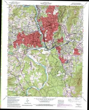
Asheville Topo Map North Carolina
To zoom in, hover over the map of Asheville
USGS Topo Quad 35082e5 - 1:24,000 scale
| Topo Map Name: | Asheville |
| USGS Topo Quad ID: | 35082e5 |
| Print Size: | ca. 21 1/4" wide x 27" high |
| Southeast Coordinates: | 35.5° N latitude / 82.5° W longitude |
| Map Center Coordinates: | 35.5625° N latitude / 82.5625° W longitude |
| U.S. State: | NC |
| Filename: | o35082e5.jpg |
| Download Map JPG Image: | Asheville topo map 1:24,000 scale |
| Map Type: | Topographic |
| Topo Series: | 7.5´ |
| Map Scale: | 1:24,000 |
| Source of Map Images: | United States Geological Survey (USGS) |
| Alternate Map Versions: |
Asheville NC 1936 Download PDF Buy paper map Asheville NC 1943 Download PDF Buy paper map Asheville NC 1943, updated 1951 Download PDF Buy paper map Asheville NC 1961, updated 1965 Download PDF Buy paper map Asheville NC 1961, updated 1988 Download PDF Buy paper map Asheville NC 1961, updated 1993 Download PDF Buy paper map Asheville NC 1976, updated 1979 Download PDF Buy paper map Asheville NC 2011 Download PDF Buy paper map Asheville NC 2013 Download PDF Buy paper map Asheville NC 2016 Download PDF Buy paper map |
| FStopo: | US Forest Service topo Asheville is available: Download FStopo PDF Download FStopo TIF |
1:24,000 Topo Quads surrounding Asheville
> Back to 35082e1 at 1:100,000 scale
> Back to 35082a1 at 1:250,000 scale
> Back to U.S. Topo Maps home
Asheville topo map: Gazetteer
Asheville: Airports
Asheville Airpark elevation 665m 2181′Asheville: Bays
The Lagoon elevation 607m 1991′Asheville: Bridges
Carrier Bridge elevation 600m 1968′Smith Bridge elevation 598m 1961′
Asheville: Dams
Lake Ashnoca Dam elevation 628m 2060′Lake Kenilworth Dam elevation 628m 2060′
Asheville: Gaps
Randall Gap elevation 936m 3070′White Fawn Gap elevation 761m 2496′
Asheville: Parks
Aston Park elevation 618m 2027′Grove Park elevation 663m 2175′
Malvern Hills Park elevation 630m 2066′
Memorial Stadium elevation 657m 2155′
Montford Park elevation 654m 2145′
Murry Hill Park elevation 632m 2073′
Norwood Park elevation 651m 2135′
Patton Avenue Park elevation 657m 2155′
Rhododendron Park elevation 647m 2122′
Richmond Hill Park elevation 655m 2148′
Walton Street Park elevation 629m 2063′
Weaver Park elevation 633m 2076′
Westside Community Park elevation 654m 2145′
Asheville: Populated Places
Albemarle elevation 680m 2230′Asheville elevation 649m 2129′
Bent Creek elevation 671m 2201′
Beverly Hills elevation 669m 2194′
Biltmore elevation 631m 2070′
Biltmore Forest elevation 693m 2273′
Bingham Heights elevation 671m 2201′
Boswell elevation 677m 2221′
Broadview elevation 644m 2112′
Brooklawn Park elevation 659m 2162′
Buena Vista elevation 680m 2230′
Camelot elevation 666m 2185′
Deaver View elevation 695m 2280′
Dogwood Grove elevation 671m 2201′
East Biltmore elevation 641m 2103′
Echo Hills elevation 663m 2175′
Emma elevation 642m 2106′
Happy Valley elevation 715m 2345′
Haw Creek elevation 651m 2135′
Hawthorne elevation 659m 2162′
Hazel Green elevation 628m 2060′
Highland Gate elevation 688m 2257′
Hillcrest Apts elevation 629m 2063′
Kenilworth elevation 665m 2181′
Knollwood elevation 636m 2086′
Lee Walker Hots elevation 629m 2063′
Linwood Park elevation 634m 2080′
Malvern Hills elevation 626m 2053′
Montford Hills elevation 647m 2122′
Mountainbrook elevation 689m 2260′
Murphy Junction elevation 611m 2004′
Oakley elevation 671m 2201′
Pisgah View elevation 639m 2096′
Redwood Village elevation 658m 2158′
Rolling Green elevation 697m 2286′
Rosebank Park elevation 671m 2201′
Sayles Village elevation 646m 2119′
Shiloh elevation 677m 2221′
Spring Time elevation 677m 2221′
Stockwood elevation 689m 2260′
Sulphur Springs elevation 629m 2063′
Valley Springs elevation 703m 2306′
Venable elevation 667m 2188′
Venable Community elevation 633m 2076′
West Asheville elevation 659m 2162′
Wilshire Park elevation 646m 2119′
Wind Oaks Town Homes elevation 727m 2385′
Woolsey elevation 656m 2152′
Asheville: Reservoirs
Bass Pond elevation 614m 2014′Bent Creek Ranch Lake elevation 647m 2122′
Busbee Reservoir elevation 654m 2145′
Dellwood Lake elevation 630m 2066′
Kenilworth Lake elevation 628m 2060′
Lake Ashnoca elevation 628m 2060′
Lake Kenilworth elevation 627m 2057′
Long Valley Lake elevation 620m 2034′
Westerly Lake elevation 643m 2109′
White Flawn Reservoir elevation 746m 2447′
Asheville: Streams
Austin Branch elevation 608m 1994′Bent Creek elevation 609m 1998′
Boring Mill Branch elevation 609m 1998′
Brown Branch elevation 627m 2057′
Buttermilk Creek elevation 609m 1998′
Canie Creek elevation 605m 1984′
Creasman Branch elevation 625m 2050′
Dingle Creek elevation 608m 1994′
Fourmile Branch elevation 605m 1984′
Gashes Creek elevation 612m 2007′
Haw Creek elevation 608m 1994′
Hominy Creek elevation 603m 1978′
Long Valley Branch elevation 602m 1975′
McKinnish Branch elevation 640m 2099′
Moore Branch elevation 603m 1978′
Plateau Branch elevation 604m 1981′
Pond Branch elevation 617m 2024′
Ragsdale Creek elevation 610m 2001′
Ram Branch elevation 610m 2001′
Reed Creek elevation 594m 1948′
Rhododendron Creek elevation 609m 1998′
Rooul Branch elevation 619m 2030′
Ross Creek elevation 607m 1991′
Smith Creek elevation 593m 1945′
Smith Mill Creek elevation 606m 1988′
Swannanoa River elevation 600m 1968′
Sweeten Creek elevation 604m 1981′
Asheville: Summits
Beaucatcher Mountain elevation 821m 2693′Busbee Mountain elevation 1065m 3494′
Cisco Mountain elevation 949m 3113′
Dryman Mountain elevation 779m 2555′
Lone Pine Mountain elevation 748m 2454′
Lookout Mountain elevation 720m 2362′
Patton Mountain elevation 949m 3113′
Piney Mountain elevation 876m 2874′
Richmond Hill elevation 690m 2263′
Sunset Mountain elevation 940m 3083′
Asheville: Tunnels
Beaucatcher Tunnel elevation 752m 2467′Asheville: Valleys
Chunn Cove elevation 642m 2106′Cisco Cove elevation 628m 2060′
Stradley Cove elevation 617m 2024′
Asheville digital topo map on disk
Buy this Asheville topo map showing relief, roads, GPS coordinates and other geographical features, as a high-resolution digital map file on DVD:
South Carolina, Western North Carolina & Northeastern Georgia
Buy digital topo maps: South Carolina, Western North Carolina & Northeastern Georgia


